Country:
 Belgium
Region:
City:
Latitude and Longitude:
Time Zone:
Postal Code:
IP information under different IP Channel
ip-api
Country
Region
City
ASN
Time Zone
ISP
Blacklist
Proxy
Latitude
Longitude
Postal
Route
IPinfo
Country
Region
City
ASN
Time Zone
ISP
Blacklist
Proxy
Latitude
Longitude
Postal
Route
MaxMind
Country
Region
City
ASN
Time Zone
ISP
Blacklist
Proxy
Latitude
Longitude
Postal
Route
Luminati
Country
BEASN
Time Zone
Europe/Brussels
ISP
Hermes Telecom BVBA
Latitude
Longitude
Postal
db-ip
Country
Region
City
ASN
Time Zone
ISP
Blacklist
Proxy
Latitude
Longitude
Postal
Route
ipdata
Country
Region
City
ASN
Time Zone
ISP
Blacklist
Proxy
Latitude
Longitude
Postal
Route
Popular places and events near this IP address
Grimbergen
Municipality in Flemish Community, Belgium
Distance: Approx. 3757 meters
Latitude and longitude: 50.93333333,4.38333333
Grimbergen (Dutch pronunciation: [ˈɣrɪmbɛrɣə(n)]) is a municipality in the province of Flemish Brabant, in the Flemish region of Belgium, 10 km (6.2 mi) north of the capital Brussels. The municipality comprises the towns of Beigem, Grimbergen, Humbeek, and Strombeek-Bever. In 2017, Grimbergen had a total population of 37,030.
Machelen
Municipality in Flemish Community, Belgium
Distance: Approx. 857 meters
Latitude and longitude: 50.91666667,4.43333333
Machelen (Dutch pronunciation: [ˈmɑxələ(n)]) is a municipality in the province of Flemish Brabant, in the Flemish region of Belgium. The municipality comprises the towns of Diegem and Machelen proper. On 1 January 2006, Machelen had a total population of 12,500.

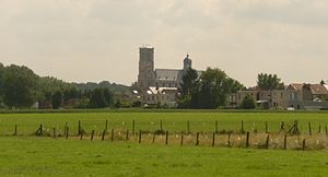
Vilvoorde
City and municipality in Flemish Community, Belgium
Distance: Approx. 1629 meters
Latitude and longitude: 50.93333333,4.41666667
Vilvoorde (Dutch pronunciation: [ˈvɪlvoːrdə] ; West Flemish: Vilvôorde; French: Vilvorde [vilvɔʁd]; historically known as Filford in English) is a Belgian city and municipality in the Halle-Vilvoorde district (arrondissement) of the province of Flemish Brabant. The municipality comprises the city of Vilvoorde proper with its two outlying quarters of Koningslo and Houtem and the small town of Peutie. The official language of Vilvoorde is Dutch, as in the rest of Flanders.
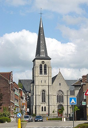
Onze-Lieve-Vrouw ten Troost
Distance: Approx. 542 meters
Latitude and longitude: 50.9277,4.4294
The Onze-Lieve-Vrouw ten Troost Kerk (Church of Our Lady of Consolation), simply known as the Troostkerk, is a basilica in Vilvoorde, Belgium. The history of the church and its Carmelite monastery (the oldest in Western Europe) go back 800 years. It was consecrated as a basilica on May 7, 2006 by Cardinal Godfried Danneels.

Diegem
Distance: Approx. 3348 meters
Latitude and longitude: 50.894232,4.435623
Diegem is a town in the municipality of Machelen, in the province of Flemish Brabant, Belgium. Diegem's postal code is 1831. The official language of Diegem is Dutch, as in the rest of Flanders.

Haren, Belgium
Neighbourhood in Brussels, Belgium
Distance: Approx. 3786 meters
Latitude and longitude: 50.89194444,4.41833333
Haren (French: [aʁɛn]; Dutch: [ˈɦaːrə(n)] ; sometimes written Haeren in French) is a former municipality of Brussels, Belgium, that was merged into the City of Brussels in 1921. It is an outlying part of the municipality and is situated at the north-eastern edge of the Brussels-Capital Region, bordering Machelen outside the boundary. Haren's postal code is 1130.

Vilvoorde Viaduct
Distance: Approx. 1547 meters
Latitude and longitude: 50.91333333,4.42138889
The Vilvoorde viaduct is part of the R0 Brussels beltway. Built as the last piece to close the Brussels beltway in 1977, it allowed the beltway to be opened for traffic on December 29 the same year. It crosses several roads, the river Zenne, the Brussels–Scheldt Maritime Canal, a railroad and the former Renault assembly plant.
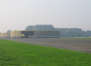
Grimbergen Airfield
Airport in Grimbergen, Belgium
Distance: Approx. 4052 meters
Latitude and longitude: 50.94861111,4.39194444
Grimbergen Airfield (Dutch: Vliegveld Grimbergen, ICAO: EBGB) is a general aviation aerodrome located in Grimbergen, a municipality of the province of Flemish Brabant in Belgium.

Military Ordinariate of Belgium
Catholic ecclesiastical jurisdiction
Distance: Approx. 3488 meters
Latitude and longitude: 50.907471,4.39301
The Military Ordinariate of Belgium (Dutch: Bisdom bij de Krijgsmacht, French: Diocèse aux Forces armées belges) is a Latin Church military ordinariate of the Catholic Church in Belgium. Immediately exempt to the Holy See, it provides pastoral care to Catholics serving in the Belgian Armed Forces and their families.

Vilvoorde Renault Factory
Distance: Approx. 1619 meters
Latitude and longitude: 50.91306,4.42028
Renault Industrie Belgique S.A. / Renault Industrie België N.V., officially shortened with the acronym RIB, opened in 1931 as an auto-assembly plant owned and operated by Renault in Vilvoorde on the northern edge of Brussels in Belgium. It was the manufacturer's first plant to be located outside France. Automobile production at Vilvoorde came to an abrupt end in 1997, with the loss of approximately 3,500 jobs, and in the face of much public opposition from and on behalf of those affected.

Haren railway station (Brussels)
Railway station in Brussels, Belgium
Distance: Approx. 4114 meters
Latitude and longitude: 50.88861111,4.41972222
Haren railway station (French: Gare de Haren; Dutch: Station Haren) is a railway station on line 26 of the Belgian railway network. It is situated in Haren, part of the City of Brussels in the Brussels-Capital Region, Belgium. The train services are operated by the National Railway Company of Belgium (NMBS/SNCB).
Haren Prison
Prison in Brussels, Belgium
Distance: Approx. 3007 meters
Latitude and longitude: 50.89796,4.42541
Haren Prison (French: Prison de Haren, Dutch: Gevangenis van Haren) is a new prison in Haren in the north-eastern part of Brussels, Belgium. It is 9.8 kilometres (6.1 mi) from Brussels-South railway station, and is near Brussels Airport, Vilvoorde Viaduct and the planned Uplace shopping centre in Machelen in Flemish Brabant, just outside Brussels. It is said to be the largest prison complex ever built in Belgium, and is intended to replace the old Saint-Gilles Prison, Forest Prison and Berkendael Prison.
Weather in this IP's area
broken clouds
13 Celsius
12 Celsius
12 Celsius
14 Celsius
1007 hPa
86 %
1007 hPa
1005 hPa
10000 meters
7.2 m/s
230 degree
75 %
07:42:59
19:20:30