Country:
 Switzerland
Region:
City:
Latitude and Longitude:
Time Zone:
Postal Code:
IP information under different IP Channel
ip-api
Country
Region
City
ASN
Time Zone
ISP
Blacklist
Proxy
Latitude
Longitude
Postal
Route
IPinfo
Country
Region
City
ASN
Time Zone
ISP
Blacklist
Proxy
Latitude
Longitude
Postal
Route
MaxMind
Country
Region
City
ASN
Time Zone
ISP
Blacklist
Proxy
Latitude
Longitude
Postal
Route
Luminati
Country
CHASN
Time Zone
Europe/Zurich
ISP
Init7 (Switzerland) Ltd.
Latitude
Longitude
Postal
db-ip
Country
Region
City
ASN
Time Zone
ISP
Blacklist
Proxy
Latitude
Longitude
Postal
Route
ipdata
Country
Region
City
ASN
Time Zone
ISP
Blacklist
Proxy
Latitude
Longitude
Postal
Route
Popular places and events near this IP address

Winterthur
City in the canton of Zürich, Switzerland
Distance: Approx. 985 meters
Latitude and longitude: 47.49888889,8.72861111
Winterthur (German pronunciation: [ˈvɪntɐtuːɐ̯] ; French: Winterthour) is a city in the canton of Zürich in northern Switzerland. With over 110,000 residents, it is the country's sixth-largest city by population, as well as its ninth-largest agglomeration with about 140,000 inhabitants. Located about 20 kilometres (12 mi) northeast of Zürich, Winterthur is a service and high-tech industrial satellite city within Greater Zürich.

Altstadt
German language word for "old town"
Distance: Approx. 985 meters
Latitude and longitude: 47.49888889,8.72861111
Altstadt (German: [ˈaltˌʃtat] ) is the German language word for "old town", and generally refers to the historical town or city centre within the old town or city wall, in contrast to younger suburbs outside. Neustadt (new town), the logical opposite of Altstadt, mostly stands for a part of the "Altstadt" in modern sense, sometimes only a few years younger than the oldest part, e. g.

Eulachhalle
Distance: Approx. 997 meters
Latitude and longitude: 47.5034,8.7118
Eulachhalle is an arena located in Winterthur, Switzerland. It is primarily used for team handball and is the home arena of Pfadi Winterthur and Yellow Winterthur. Eulachhalle holds 2,300 people.
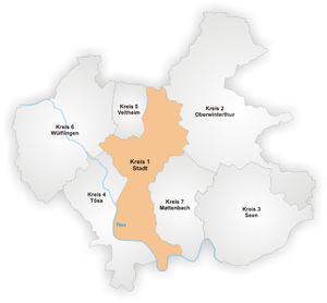
Stadt (Winterthur)
District in Zürich, Switzerland
Distance: Approx. 1016 meters
Latitude and longitude: 47.499,8.729
Stadt is a district in the Swiss city of Winterthur. It is district number 1, thus mainly comprising the original city. The district comprises the quarters Altstadt, Lind, Heiligberg, Tössfeld, Brühlberg and Neuwiesen.

Eichliacker
Distance: Approx. 910 meters
Latitude and longitude: 47.48777778,8.71138889
Eichliacker is a quarter in the district 4 of Winterthur. It was formerly a part of Töss municipality, which was incorporated into Winterthur in 1922.

Stadion Schützenwiese
Football stadium in Winterthur, Switzerland
Distance: Approx. 632 meters
Latitude and longitude: 47.500755,8.71751
Stadion Schützenwiese is a football stadium in Winterthur, Switzerland. It has been the home ground of FC Winterthur since the club's inception in 1896. It has a capacity of 8,550, more specifically 1,100 covered seats, 800 uncovered seats and 6,650 standing places.
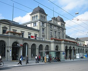
Winterthur railway station
Railway station in Winterthur, Switzerland
Distance: Approx. 785 meters
Latitude and longitude: 47.50032778,8.72378611
Winterthur railway station (German: Bahnhof Winterthur) is the principal railway station of Winterthur, in the Swiss canton of Zürich. The station is listed on the Swiss Inventory of Cultural Property of National Significance. Winterthur is Switzerland's fifth busiest station, and is a major node between Switzerland's largest railway nucleus in Zürich and places in Eastern Switzerland (such as St.

Kunstmuseum Winterthur
Art museum in Winterthur, Switzerland
Distance: Approx. 1233 meters
Latitude and longitude: 47.50138889,8.73027778
The Kunst Museum Winterthur (The Winterthur Museum of Art) is an art museum in Winterthur, Switzerland run by the local Kunstverein. From its beginnings, the activities of the Kunstverein Winterthur were focused on contemporary art – first Impressionism, then Post-Impressionism and especially Les Nabis, through post-World War II and recently created works by Richard Hamilton, Mario Merz and Gerhard Richter.
Zurich University of Applied Sciences/ZHAW
University in Zurich, Switzerland
Distance: Approx. 1015 meters
Latitude and longitude: 47.49694444,8.73
The Zurich University of Applied Sciences (ZHAW; German: Zürcher Hochschule für Angewandte Wissenschaften) located in the city of Winterthur, with facilities in Zurich and Wädenswil, is one of the largest University of Applied Sciences in Switzerland and is part of the Zürcher Fachhochschule. Currently, the university has eight departments, covering architecture and civil engineering, health, linguistics, life sciences and facility management, applied psychology, social work, engineering and management and law. The ZHAW School of Management and Law obtained AACSB accreditation in 2015.

Töss Monastery
Distance: Approx. 1315 meters
Latitude and longitude: 47.487658,8.70321
Töss Monastery was a community of Dominican nuns located in the former Swiss city of Töss, now a part of Winterthur. Nothing of the original buildings exists today. Construction of the monastery began in 1233, near the bridge at the Töss River by command of Count Hartmann IV of Kyburg.

Trams in Winterthur
Former tram system in Switzerland (1898–1951)
Distance: Approx. 735 meters
Latitude and longitude: 47.5,8.72333333
The Winterthur tramway network (Alemannic German: Strassenbahnnetz Winterthur) was part of the public transport network of the city of Winterthur, in the canton of Zürich, Switzerland, for more than 50 years. Opened in 1898, the network also served the neighbouring communities of Töss, Wülflingen, Oberwinterthur and Seen, all of which were incorporated into the municipality of Winterthur in 1922. After reaching its maximum extent in 1931, the network was gradually replaced from 1938 by the Winterthur trolleybus system, until the network's closure in 1951.

Winterthur Töss railway station
Railway station in Winterthur, Switzerland
Distance: Approx. 829 meters
Latitude and longitude: 47.489391,8.709701
Winterthur Töss railway station is a railway station in the Swiss canton of Zurich and city of Winterthur. It takes its name from that city's quarter of Töss in which it is located. The station is located on the Winterthur to Koblenz via Bülach line.
Weather in this IP's area
few clouds
20 Celsius
20 Celsius
19 Celsius
22 Celsius
1012 hPa
77 %
1012 hPa
963 hPa
10000 meters
3.09 m/s
300 degree
20 %
06:53:38
19:52:10