185.201.159.119 - IP Lookup: Free IP Address Lookup, Postal Code Lookup, IP Location Lookup, IP ASN, Public IP
Country:
 Austria
Region:
City:
Location:
Time Zone:
Postal Code:
ISP:
ASN:
language:
User-Agent:
Proxy IP:
Blacklist:
IP information under different IP Channel
ip-api
Country
Region
City
ASN
Time Zone
ISP
Blacklist
Proxy
Latitude
Longitude
Postal
Route
db-ip
Country
Region
City
ASN
Time Zone
ISP
Blacklist
Proxy
Latitude
Longitude
Postal
Route
IPinfo
Country
Region
City
ASN
Time Zone
ISP
Blacklist
Proxy
Latitude
Longitude
Postal
Route
IP2Location
185.201.159.119Country
atRegion
salzburg
City
kleinarl
Time Zone
Europe/Vienna
ISP
Language
User-Agent
Latitude
Longitude
Postal
ipdata
Country
Region
City
ASN
Time Zone
ISP
Blacklist
Proxy
Latitude
Longitude
Postal
Route
Popular places and events near this IP address

Geography of Austria
Distance: Approx. 6335 meters
Latitude and longitude: 47.33333333,13.33333333
Austria is a predominantly mountainous country in Central Europe, approximately between Germany, Italy and Hungary. It has a total area of 83,871 square kilometres (32,383 sq mi). Austria shares national borders with Switzerland (a non-European Union member state, which it borders for 158 km, or 98 mi) and the principality of Liechtenstein (also a non-EU member state, of which it borders for 34 km or 21 mi) to the west, Germany (801 km or 497 mi) and the Czech Republic (402 km or 249 mi) and Slovakia (105 km or 65 mi) to the north, Hungary to the east (331 km or 205 mi), and Slovenia (330 km or 185 mi) and Italy (404 km or 251 mi) to the south (total: 2,534 km or 1,574 mi).

Flachau
Municipality in Salzburg, Austria
Distance: Approx. 9133 meters
Latitude and longitude: 47.34277778,13.39222222
Flachau is a village in the district of St. Johann im Pongau in the Austrian state of Salzburg, with a population of 2,802 (2016 data). Its numerous skiing facilities are part of the Ski Amadé network of ski areas, one of the largest in Europe.

Dorfgastein
Municipality in Salzburg, Austria
Distance: Approx. 5555 meters
Latitude and longitude: 47.2425,13.26666667
Dorfgastein is a municipality in St. Johann im Pongau District, in the Austrian state of Salzburg.
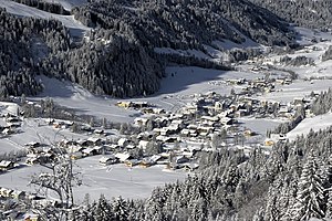
Kleinarl
Municipality in Salzburg, Austria
Distance: Approx. 1192 meters
Latitude and longitude: 47.26666667,13.31666667
Kleinarl is a municipality in the St. Johann im Pongau district in the Austrian state of Salzburg.

Wagrain
Municipality in Salzburg, Austria
Distance: Approx. 6420 meters
Latitude and longitude: 47.33333333,13.3
Wagrain (Austro-Bavarian: Wågroã) is a market town in the St. Johann im Pongau District in the Austrian state of Salzburg. It is located in a high valley stretching from the Salzach at Sankt Johann in the west to the Enns river in the east.

Austria
Country in Central Europe
Distance: Approx. 6335 meters
Latitude and longitude: 47.33333333,13.33333333
Austria, formally the Republic of Austria, is a landlocked country in Central Europe, lying in the Eastern Alps. It is a federation of nine states, one of which is the capital, Vienna, the most populous city and state. Austria is bordered by Germany to the northwest, the Czech Republic to the north, Slovakia to the northeast, Hungary to the east, Slovenia and Italy to the south, and Switzerland and Liechtenstein to the west.
Weather in this IP's area
clear sky
1 Celsius
-3 Celsius
1 Celsius
1 Celsius
1032 hPa
64 %
1032 hPa
854 hPa
10000 meters
2.9 m/s
1.98 m/s
170 degree