Country:
 Netherlands
Region:
City:
Latitude and Longitude:
Time Zone:
Postal Code:
IP information under different IP Channel
ip-api
Country
Region
City
ASN
Time Zone
ISP
Blacklist
Proxy
Latitude
Longitude
Postal
Route
IPinfo
Country
Region
City
ASN
Time Zone
ISP
Blacklist
Proxy
Latitude
Longitude
Postal
Route
MaxMind
Country
Region
City
ASN
Time Zone
ISP
Blacklist
Proxy
Latitude
Longitude
Postal
Route
Luminati
Country
NLRegion
ze
City
sluis
ASN
Time Zone
Europe/Amsterdam
ISP
DELTA Fiber Nederland B.V.
Latitude
Longitude
Postal
db-ip
Country
Region
City
ASN
Time Zone
ISP
Blacklist
Proxy
Latitude
Longitude
Postal
Route
ipdata
Country
Region
City
ASN
Time Zone
ISP
Blacklist
Proxy
Latitude
Longitude
Postal
Route
Popular places and events near this IP address

Sluis-Aardenburg
Distance: Approx. 462 meters
Latitude and longitude: 51.30937,3.38791
Sluis-Aardenburg was a municipality in the province of Zeeland, in the south-western part of the Netherlands. It was created from a merger of Sluis and Aardenburg in 1995, and it merged with the municipality of Oostburg, on 1 January 2003, to form the new municipality of Sluis. Sluis-Aardenburg covered an area of 83.48 km2, of which 0.89 km2 was water.

Sluis
Municipality in Zeeland, Netherlands
Distance: Approx. 304 meters
Latitude and longitude: 51.30833333,3.38611111
Sluis (Dutch: [slœys] ; Zeelandic: Sluus [slys]; French: Écluse) is a city and municipality located in the west of Zeelandic Flanders, in the south-western Dutch province of Zeeland. The current incarnation of the municipality has existed since 1 January 2003. The former municipalities of Oostburg and Sluis-Aardenburg merged on that date.
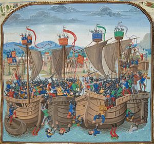
Battle of Sluys
Naval battle during the Hundred Years' War
Distance: Approx. 4744 meters
Latitude and longitude: 51.35,3.375
The Battle of Sluys (; Dutch pronunciation: [slœys]), also called the Battle of l'Écluse, was a naval battle fought on 24 June 1340 between England and France. It took place in the roadstead of the port of Sluys (French Écluse), on a since silted-up inlet between Zeeland and West Flanders. The English fleet of 120–150 ships was led by Edward III of England and the 230-strong French fleet by the Breton knight Hugues Quiéret, Admiral of France, and Nicolas Béhuchet, Constable of France.
Hoeke
Village in West Flanders, Belgium
Distance: Approx. 4327 meters
Latitude and longitude: 51.28333333,3.33333333
Hoeke is a village in Damme, a municipality in West Flanders, Belgium.
Lapscheure
Distance: Approx. 3497 meters
Latitude and longitude: 51.28333333,3.35
Lapscheure is a town in Damme, a municipality in the province of West Flanders, Belgium.

Sint Anna ter Muiden
Small city in Zeeland, Netherlands
Distance: Approx. 1450 meters
Latitude and longitude: 51.31444444,3.36416667
Sint Anna ter Muiden is a small city in the province of Zeeland, Netherlands. It is administratively a part of municipality of Sluis, and the town of Sluis lies about 1 km east. It is located on the westernmost point of the Netherlands (excluding the kingdom's other countries and its special municipalities).

Battle of Sluis (1603)
1603 naval battle between a Spanish royal and a Dutch rebel fleet
Distance: Approx. 2866 meters
Latitude and longitude: 51.33333333,3.38333333
The Battle of Sluis was a naval battle during the Eighty Years' War in which a Spanish squadron commanded by the Italian captain Federico Spinola tried to break through a blockade of Sluis by Dutch ships under the command of Joos de Moor. After about two hours of fighting the heavily damaged Spanish ships returned to Sluis. Federico Spinola was killed during the action.
Heille
Hamlet in Zeeland, Netherlands
Distance: Approx. 5151 meters
Latitude and longitude: 51.2657,3.4133
Heille is a hamlet in the Dutch province of Zeeland. It is located on the Belgium border, about 2 km west of Aardenburg in the municipality of Sluis. Heille is not a statistical entity, and the postal authorities have placed it under Sluis.

Retranchement
Village in Zeeland, Netherlands
Distance: Approx. 4477 meters
Latitude and longitude: 51.34777778,3.38472222
Retranchement is a village in the Dutch province of Zeeland. It is located on the Belgian border, about 9 km northwest of Oostburg, in the municipality of Sluis.
Oud Sluis
Restaurant in Sluis, Netherlands
Distance: Approx. 394 meters
Latitude and longitude: 51.30713889,3.38750833
Oud Sluis is a defunct restaurant in Sluis, Netherlands. It was a fine dining restaurant that had been awarded one or more Michelin stars since 1995. It carried one star in the period 1995–1998, two stars in the period 1999–2005 and three stars from 2006.
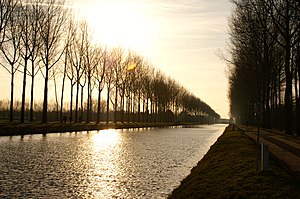
Damme Canal
Canal in Belgium
Distance: Approx. 222 meters
Latitude and longitude: 51.30805556,3.385
The Damme Canal (French: Canal de Damme. Dutch: Damse Vaart or Napoleonvaart) is a canal in the Belgian province of West Flanders. The canal links Bruges with the Western Scheldt at Sluis, Netherlands.

Siege of Sluis (1604)
Distance: Approx. 304 meters
Latitude and longitude: 51.30833333,3.38611111
The siege of Sluis (1604), also known as the Sluis campaign or the Battle of the Oostburg Line, was a series of military actions that took place during the Eighty Years' War and the Anglo–Spanish War from 19 May to 19 August 1604. A States and English army under Prince Maurice of Orange and Horace Vere respectively crossed the Scheldt estuary and advanced on land taking Cadzand, Aardenburg, and IJzendijke in the Spanish Netherlands. This soon led to the culmination of the siege of the Spanish-held inland port of Sluis.
Weather in this IP's area
broken clouds
20 Celsius
19 Celsius
19 Celsius
21 Celsius
1007 hPa
55 %
1007 hPa
1007 hPa
10000 meters
7.92 m/s
9.58 m/s
193 degree
56 %
07:11:04
20:17:25