Country:
 Great Britain
Region:
City:
Latitude and Longitude:
Time Zone:
Postal Code:
IP information under different IP Channel
ip-api
Country
Region
City
ASN
Time Zone
ISP
Blacklist
Proxy
Latitude
Longitude
Postal
Route
IPinfo
Country
Region
City
ASN
Time Zone
ISP
Blacklist
Proxy
Latitude
Longitude
Postal
Route
MaxMind
Country
Region
City
ASN
Time Zone
ISP
Blacklist
Proxy
Latitude
Longitude
Postal
Route
Luminati
Country
GBRegion
eng
City
hull
ASN
Time Zone
Europe/London
ISP
MS3 Networks Ltd
Latitude
Longitude
Postal
db-ip
Country
Region
City
ASN
Time Zone
ISP
Blacklist
Proxy
Latitude
Longitude
Postal
Route
ipdata
Country
Region
City
ASN
Time Zone
ISP
Blacklist
Proxy
Latitude
Longitude
Postal
Route
Popular places and events near this IP address

Arctic Corsair
Museum ship in Kingston upon Hull, England
Distance: Approx. 115 meters
Latitude and longitude: 53.74277778,-0.32777778
The Arctic Corsair (H320) is a deep-sea trawler, built in 1960, that was converted to a museum ship in 1999. She is temporarily berthed at Alexandra Dock in Kingston upon Hull, England, pending completion of a new permanent location in the city's Museums Quarter. Exhibits and guides aboard the boat tell the story of Hull's deep-sea fishing industry.

Wilberforce House
Historic house museum in Kingston upon Hull, England
Distance: Approx. 211 meters
Latitude and longitude: 53.744461,-0.330073
Wilberforce House is a British historic house museum, part of the Museums Quarter of Kingston-upon-Hull. It is the birthplace of social reformer William Wilberforce (1759–1833), who used his time as a member of Parliament to work for the abolition of slavery throughout the British Empire. Like the nearby Blaydes House and Maister House, also on the High Street, the Grade I listed building was formerly a merchant's house with access to quayside on the River Hull.
Siege of Hull (1642)
First major action of the English Civil War 1642
Distance: Approx. 227 meters
Latitude and longitude: 53.744,-0.332
The first siege of Hull marked a major escalation in the conflict between King Charles I and Parliament during the build-up to the First English Civil War. Charles sought to secure the large arsenal held in Kingston upon Hull, East Riding of Yorkshire. He first approached the town in late April 1642 and was rebuffed by the town's Parliamentarian governor, Sir John Hotham.

William Crampton Library
Distance: Approx. 146 meters
Latitude and longitude: 53.74364,-0.33086
The William Crampton Library, so named in honour of Dr William Crampton, founder of the Flag Institute, is the United Kingdom's largest single library devoted to the subject of vexillology. Opened by the Lord Mayor of Kingston upon Hull and William's daughter Elanor in May 1999, The William Crampton library of the Flag Institute was originally located in the James Ricket Library Building in Hull. In November 2006 it moved premises to the Hull Business Centre Building.

Hull Castle
Former artillery fort in Kingston upon Hull in England
Distance: Approx. 205 meters
Latitude and longitude: 53.74339,-0.326679
Hull Castle was an artillery fort in Kingston upon Hull in England. Together with two supporting blockhouses, it defended the eastern side of the River Hull, and was constructed by King Henry VIII to protect against attack from France as part of his Device programme in 1542. The castle had two large, curved bastions and a rectangular keep at its centre; the blockhouses to the north and south had three curved bastions supporting guns, and a curtain wall and moat linked the blockhouses and castle.

Streetlife Museum of Transport
Transport museum in Kingston upon Hull, England
Distance: Approx. 144 meters
Latitude and longitude: 53.74388889,-0.32972222
The Streetlife Museum of Transport is a transport museum located in Kingston upon Hull, England. The roots of the collection date back to the early 20th century, however the purpose-built museum the collection is housed in was opened in 1989 by the then Hull East MP, John Prescott. Core areas of the collection include Veteran cars, horse-drawn carriages and objects relating to local public transport.
Kingston upon Hull College of Education
Distance: Approx. 227 meters
Latitude and longitude: 53.744,-0.332
Kingston upon Hull College of Education was founded in 1913 as the "Hull Municipal Training College". The college had numerous name changes until September 1976 when it merged with the Hull College of Higher Education, which ultimately formed part of the University of Lincoln. The stimulus for the formation of the college was in response to a shortage of certified teachers in the city's schools.
Oriel Chambers, Kingston upon Hull
Distance: Approx. 171 meters
Latitude and longitude: 53.74406,-0.33029
Oriel Chambers is a Grade II listed building which, since 2006, has housed the Wilberforce Institute for the study of Slavery and Emancipation. It is located in the city of Kingston upon Hull, in the East Riding of Yorkshire, England.
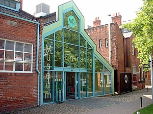
Hull and East Riding Museum
Museum in Kingston upon Hull, East Riding of Yorkshire, England
Distance: Approx. 103 meters
Latitude and longitude: 53.7434,-0.3303
The Hull and East Riding Museum of Archaeology is located in the Museums Quarter of the Old Town in Kingston upon Hull, England. It dates back to 1925 as the Museum of Commerce and Industry in a former Customs House but acquired its present name in 1989 with a major refurbishment and new entrance, with the transport section moving to a separate museum. It displays items from prehistoric to medieval in the area, many of them in life-size tableaux or reconstructions of rooms and buildings.
Scale Lane Footbridge
Pedestrian bridge in Hull, England
Distance: Approx. 34 meters
Latitude and longitude: 53.7424,-0.3299
Scale Lane Footbridge is an apostrophe-shaped pedestrian swing bridge in Hull, England. The bridge has a rotating mechanism, allowing it to swing open horizontally, letting vessels pass beneath on the River Hull. It was the first bridge in the world to allow pedestrians to remain on the bridge while it is in motion.

Kingston upon Hull Combined Court Centre
Judicial building in Kingston upon Hull, England
Distance: Approx. 221 meters
Latitude and longitude: 53.7441,-0.3317
The Kingston upon Hull Combined Court Centre is a Crown Court venue, which deals with criminal cases, as well as a County Court, which deals with civil cases, in Lowgate, Kingston upon Hull, England.

Myton Swing Bridge
Road bridge in Hull, Yorkshire, England
Distance: Approx. 209 meters
Latitude and longitude: 53.7408,-0.3304
Myton Swing Bridge is a road bridge over the River Hull, in the city of Kingston upon Hull, Yorkshire, England. The bridge carries the A63 road through the south of the city connecting the west and east regions of Hull. Designed by the firm of Freeman Fox and Partners, with engineering undertaken by Cleveland Bridge, it was the largest swing bridge in Britain when it was opened in 1980.
Weather in this IP's area
scattered clouds
19 Celsius
17 Celsius
19 Celsius
20 Celsius
1003 hPa
16 %
1003 hPa
1002 hPa
10000 meters
5.14 m/s
220 degree
40 %
06:23:02
19:35:07