Country:
 Argentina
Region:
City:
Latitude and Longitude:
Time Zone:
Postal Code:
IP information under different IP Channel
ip-api
Country
Region
City
ASN
Time Zone
ISP
Blacklist
Proxy
Latitude
Longitude
Postal
Route
IPinfo
Country
Region
City
ASN
Time Zone
ISP
Blacklist
Proxy
Latitude
Longitude
Postal
Route
MaxMind
Country
Region
City
ASN
Time Zone
ISP
Blacklist
Proxy
Latitude
Longitude
Postal
Route
Luminati
Country
ARRegion
c
City
buenosaires
ASN
Time Zone
America/Argentina/Buenos_Aires
ISP
i3D.net B.V
Latitude
Longitude
Postal
db-ip
Country
Region
City
ASN
Time Zone
ISP
Blacklist
Proxy
Latitude
Longitude
Postal
Route
ipdata
Country
Region
City
ASN
Time Zone
ISP
Blacklist
Proxy
Latitude
Longitude
Postal
Route
Popular places and events near this IP address
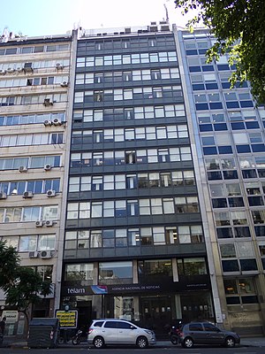
Télam
Argentine national news agency
Distance: Approx. 792 meters
Latitude and longitude: -34.61416667,-58.37333333
Télam (an acronym for "Telenoticiosa Americana") was an Argentine government-ran national news agency founded in 1945 by then Secretary of Labor Juan Perón during the presidency of Edelmiro Julián Farrell. Télam was the biggest newswire of Latin America with about 2,800 subscribers. The service was suspended in March 2024 by the government of President Javier Milei.
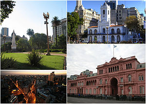
Monserrat, Buenos Aires
Barrio in Buenos Aires, Argentina
Distance: Approx. 610 meters
Latitude and longitude: -34.6125,-58.38333333
Monserrat or Montserrat (pronounced [monseˈrat]) is a neighbourhood in the east of the Buenos Aires CBD. The district features some of the most important public buildings in Buenos Aires, including city hall, the city legislature, Casa Rosada, the Colegio Nacional de Buenos Aires and the Libertador Building (Ministry of Defense), among others. Avenida de Mayo runs through the Monserrat district, connecting Plaza de Mayo and the Plaza de los Dos Congresos (Congressional Plaza). A block, or two, south of the Plaza de Mayo, the older section of Monserrat begins.

Universidad Argentina de la Empresa
Private university in Argentina
Distance: Approx. 124 meters
Latitude and longitude: -34.6167,-58.3817
The Argentine University of Enterprise (Spanish: Universidad Argentina de la Empresa, mostly known for its acronym UADE) is a private university in Buenos Aires, Argentina. It was founded by the Argentine Chamber of Corporations. It is one of the top private universities in Buenos Aires.

Ministry of Public Works Building, Buenos Aires
Public building in Buenos Aires, Argentina
Distance: Approx. 631 meters
Latitude and longitude: -34.61194444,-58.38138889
The Ministry of Public Works Building (Spanish: Edificio del Ministerio de Obras Públicas), now known as the Ministry of Health Building (Spanish: Edificio del Ministerio de Salud) is a public building in the rationalist style located on the intersection of 9 de Julio Avenue and Belgrano Avenue, in the neighborhood of Monserrat, in Buenos Aires, Argentina. It is currently used by the Argentine Ministry of Health. On both the north and south walls, there are large steel portraits of María Eva Duarte de Perón, better known as Evita Perón.

Moreno (Buenos Aires Underground)
Buenos Aires Underground station
Distance: Approx. 556 meters
Latitude and longitude: -34.61261111,-58.38058333
Moreno is a station on Line C of the Buenos Aires Underground in Argentina. From here passengers may transfer to Metrobus 9 de Julio. The station was opened on 9 November 1934 as part of the inaugural section of the line, from Constitución to Diagonal Norte.

Independencia (Line C Buenos Aires Underground)
Buenos Aires Underground station
Distance: Approx. 82 meters
Latitude and longitude: -34.61811111,-58.38025
Independencia is a station on Line C of the Buenos Aires Underground. From here, passengers may transfer to the Independencia Station on Line E and Metrobus 9 de Julio. The station was opened on 9 November 1934 as part of the inaugural section of the line, from Constitución to Diagonal Norte.

San Juan (Buenos Aires Underground)
Buenos Aires Underground station
Distance: Approx. 488 meters
Latitude and longitude: -34.62191667,-58.38
San Juan is a station on Line C of the Buenos Aires Underground. The station was opened on 9 November 1934 as part of the inaugural section of the line, from Constitución to Diagonal Norte.
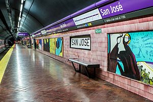
San José (Buenos Aires Underground)
Buenos Aires Underground station
Distance: Approx. 655 meters
Latitude and longitude: -34.62233333,-58.38513889
San José is a station on Line E of the Buenos Aires Underground. The old station San José vieja was closed the year the current station opened, after the line was re-routed from Constitucion railway station to its current trajectory. The station was opened on 20 June 1944 as the eastern terminus of the inaugural section of the line from San José to General Urquiza.

Independencia (Line E Buenos Aires Underground)
Buenos Aires Underground station
Distance: Approx. 67 meters
Latitude and longitude: -34.61794444,-58.3815
Independencia is a station on Line E of the Buenos Aires Underground. From here, passengers may transfer to the Independencia Station on Line C and Metrobus 9 de Julio. The station was opened on 24 April 1966 as part of the extension of the line from San José to Bolívar.

Belgrano (Buenos Aires Underground)
Buenos Aires Underground station
Distance: Approx. 611 meters
Latitude and longitude: -34.61286111,-58.37752778
Belgrano is a station on Line E of the Buenos Aires Underground. The station was opened on 24 April 1966 as part of the extension of the line from San José to Bolívar. The name of the station pays homage to Manuel Belgrano, creator of the Argentinian flag.

Radio Disney (Argentina)
Radio Disney radio station in Buenos Aires, Argentina
Distance: Approx. 630 meters
Latitude and longitude: -34.61194444,-58.38083333
LRL301 (94.3 FM, also called Radio Disney Argentina) is a radio station broadcasting current music. Licensed to Buenos Aires, Argentina, the station serves the Greater Buenos Aires area. The station is currently owned by Difusora Baires S.A. (Radio Medios S.A., The Walt Disney Company Argentina and ABC Venture Corp.), and features programming from Radio Disney, a radio network whose flagship station is LRL301 itself.

Otto Wulff Building
Distance: Approx. 790 meters
Latitude and longitude: -34.6125,-58.3749
Otto Wulff building (Spanish: Edificio Otto Wulff) is a historic building of Buenos Aires. It is located in the corner of Belgrano and Peru, neighborhood of Monserrat. This building was built on the grounds of an old colonial house known by the name of "La Casa de la Virreina Vieja", which had been owned by the Viceroy Joaquín del Pino and his family.
Weather in this IP's area
clear sky
13 Celsius
12 Celsius
11 Celsius
14 Celsius
1019 hPa
65 %
1019 hPa
1016 hPa
10000 meters
4.92 m/s
120 degree
3 %
07:02:20
18:40:08