Country:
 Russian Federation
Region:
City:
Latitude and Longitude:
Time Zone:
Postal Code:
IP information under different IP Channel
ip-api
Country
Region
City
ASN
Time Zone
ISP
Blacklist
Proxy
Latitude
Longitude
Postal
Route
IPinfo
Country
Region
City
ASN
Time Zone
ISP
Blacklist
Proxy
Latitude
Longitude
Postal
Route
MaxMind
Country
Region
City
ASN
Time Zone
ISP
Blacklist
Proxy
Latitude
Longitude
Postal
Route
Luminati
Country
RUASN
Time Zone
Europe/Moscow
ISP
Ojsc Sheremetyevo International Airport
Latitude
Longitude
Postal
db-ip
Country
Region
City
ASN
Time Zone
ISP
Blacklist
Proxy
Latitude
Longitude
Postal
Route
ipdata
Country
Region
City
ASN
Time Zone
ISP
Blacklist
Proxy
Latitude
Longitude
Postal
Route
Popular places and events near this IP address

Sheremetyevo International Airport
International airport serving Moscow, Russia
Distance: Approx. 166 meters
Latitude and longitude: 55.97277778,37.41472222
Sheremetyevo Alexander S. Pushkin International Airport (Russian: Международный аэропорт Шереметьево имени А. С. Пушкина, romanized: Mezhdunarodny aeroport Sheremetyevo imeni A. S. Pushkina, IPA: [ʂɨrʲɪˈmʲetʲjɪvə]) (IATA: SVO, ICAO: UUEE) is one of four international airports that serve the city of Moscow. It is the busiest airport in Russia, as well as the 11th-busiest airport in Europe. Originally built as a military airbase, Sheremetyevo was converted into a civilian airport in 1959.

Dolgoprudny
Town in Moscow Oblast, Russia
Distance: Approx. 7059 meters
Latitude and longitude: 55.93333333,37.5
Dolgoprudny (Russian: Долгопру́дный, Russian pronunciation: [dəlɡɐˈprudnɨj]) is a town in Moscow Oblast, Russia, located about 20 kilometers (12 mi) north of Moscow city center. The town's name is derived from Russian "Долгий пруд" (dolgy prud, lit. "long pond")—a long and narrow pond situated in the northeastern part of the town.

Lobnya
Town in Moscow Oblast, Russia
Distance: Approx. 6514 meters
Latitude and longitude: 56.01666667,37.48333333
Lobnya (Russian: Ло́бня) is a town in Moscow Oblast, Russia, located 30 kilometres (19 mi) north west of Moscow. Population: 82,764 (2021 Census); 74,252 (2010 Census); 61,567 (2002 Census); 60,475 (1989 Soviet census); 30,000 (1970).

Skhodnya
Distance: Approx. 7486 meters
Latitude and longitude: 55.95,37.3
Skhodnya (Russian: Сходня) was formerly a town in Moscow Oblast, Russia, located on the Skhodnya River some 12 km northwest of Moscow. On September 15, 2004, it was merged into the city of Khimki. Skhodnya's population was recorded at 19,119 inhabitants as of the 2002 Census; down from 20,366 recorded in the 1989 Census.
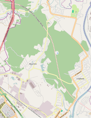
Khimki Forest
Forest near Moscow, Russia
Distance: Approx. 4796 meters
Latitude and longitude: 55.935,37.44666667
Khimki Forest (Russian: Химкинский лес, romanized: Khimkinskiy les) is a forest near the Russian city of Moscow covering about 1000 hectares. It is part of the so-called "Green Belt" around Moscow. An $8 billion high speed road, the Moscow–Saint Petersburg motorway (M11), was proposed in the aughts to go through the forest to connect Moscow and Saint Petersburg.
Molzhaninovsky District
District in federal city of Moscow, Russia
Distance: Approx. 4978 meters
Latitude and longitude: 55.93083333,37.38916667
Molzhaninovsky District (Russian: Молжани́новский райо́н) is an administrative district (raion), one of the sixteen in Northern Administrative Okrug of the federal city of Moscow, Russia. The area of the district is 16.65 square kilometres (6.43 sq mi) As of the 2010 Census, the total population of the district was 3,521.

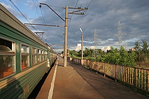
Molzhaninovo railway station
Railway station in Moscow, Russia
Distance: Approx. 5825 meters
Latitude and longitude: 55.9243,37.3812
Molzhaninovo, formerly Planernaya, is a railway station located on the north side of Khimki on the Moscow-St Petersburg Railway. It serves the Leningradsky suburban railway line.

Pulkovo Aviation Enterprise Flight 9560
2002 aviation accident
Distance: Approx. 4690 meters
Latitude and longitude: 55.98833333,37.48305556
Pulkovo Aviation Enterprise Flight 9560 was a repositioning flight from Sheremetyevo International Airport in Moscow to Pulkovo Airport in St. Petersburg. On 28 July 2002, the Ilyushin Il-86 aircraft operating the flight crashed after take-off from Sheremetyevo.

Aeroflot Flight 1492
Aviation accident in Moscow on 5 May 2019
Distance: Approx. 881 meters
Latitude and longitude: 55.96833333,37.40194444
Aeroflot Flight 1492 was a scheduled domestic passenger flight operated by Aeroflot from Moscow–Sheremetyevo to Murmansk, Russia. On 5 May 2019, the Sukhoi Superjet 100 aircraft operating the flight was climbing out when it was struck by lightning. The aircraft suffered an electrical failure and returned to Sheremetyevo for an emergency landing.

Lobnya railway station
Railway station in Moscow Oblast, Russia
Distance: Approx. 6346 meters
Latitude and longitude: 56.0135,37.4853
Lobnya is a terminus railway station for Line D1 of the Moscow Central Diameters in Moscow Oblast and intermediate for other trains towards Dmitrov and other cities. It was opened in 1901 and will be rebuilt in 2021 - 2024.
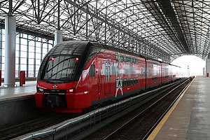
Aeroport Sheremetyevo railway station
Railway station in Moscow, Russia
Distance: Approx. 1112 meters
Latitude and longitude: 55.9641,37.418
Aeroport Sheremetyevo is a railway station in Sheremetyevo Airport which is served by Aeroexpress. It was opened on 10 June 2008.

Chashnikovo (Lunyovskoye rural settlement)
Village in Moscow Oblast, Russia
Distance: Approx. 1760 meters
Latitude and longitude: 55.98888889,37.40527778
Chashnikovo (Russian: Чашниково) is a rural locality (a village) located in the southeast of the Solnechnogorski District, in the central part of the Moscow Oblast, about 34 km southeast of the city of Solnechnogorsk, 12 km from the Moscow Ring Road, just north of Sheremetyevo Airport on the left bank of the Meshcherikha River, which flows into the Klyazma. There are 5 streets in the village - Novaya, Promyshlennaya, Tsentralnaya, Shkolnaya and Kolesny proezd, 3 microdistricts, a garden partnership, a dacha partnership and a dacha cooperative are registered. The nearest settlements are the villages of Isakovo, Nosovo and Perepechino.
Weather in this IP's area
clear sky
6 Celsius
5 Celsius
5 Celsius
8 Celsius
1031 hPa
81 %
1031 hPa
1008 hPa
10000 meters
2 m/s
330 degree
07:10:02
17:20:11