Country:
 France
Region:
City:
Latitude and Longitude:
Time Zone:
Postal Code:
IP information under different IP Channel
ip-api
Country
Region
City
ASN
Time Zone
ISP
Blacklist
Proxy
Latitude
Longitude
Postal
Route
IPinfo
Country
Region
City
ASN
Time Zone
ISP
Blacklist
Proxy
Latitude
Longitude
Postal
Route
MaxMind
Country
Region
City
ASN
Time Zone
ISP
Blacklist
Proxy
Latitude
Longitude
Postal
Route
Luminati
Country
FRRegion
idf
City
clamart
ASN
Time Zone
Europe/Paris
ISP
ADISTA SAS
Latitude
Longitude
Postal
db-ip
Country
Region
City
ASN
Time Zone
ISP
Blacklist
Proxy
Latitude
Longitude
Postal
Route
ipdata
Country
Region
City
ASN
Time Zone
ISP
Blacklist
Proxy
Latitude
Longitude
Postal
Route
Popular places and events near this IP address

Aiguille de Bionnassay
Mountain in the Mont Blanc massif
Distance: Approx. 7114 meters
Latitude and longitude: 45.83583333,6.81805556
The Aiguille de Bionnassay (elevation 4,052 metres (13,294 ft)) is a mountain in the Mont Blanc massif of the Alps in France and Italy. It has been described as "one of the most attractive satellite peaks of Mont Blanc", and is located on its western side.: 51 The mountain's south and east ridges form the frontier between the two countries, and its summit is a knife-edge crest of snow and ice.

Les Contamines-Montjoie
Commune in south-eastern France
Distance: Approx. 145 meters
Latitude and longitude: 45.8225,6.73
Les Contamines-Montjoie (French pronunciation: [le kɔ̃tamin mɔ̃ʒwa]) is a commune in the Haute-Savoie department in the Auvergne-Rhône-Alpes region in south-eastern France.
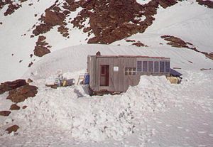
Durier Hut
Mountain hut in the Mont Blanc massif
Distance: Approx. 6466 meters
Latitude and longitude: 45.82533333,6.81183333
The Durier Hut (French: Refuge Durier) is a mountain hut in the Mont Blanc massif of the Alps. It is located in Haute-Savoie department of France on the French/Italian border at an altitude of 3358 m.
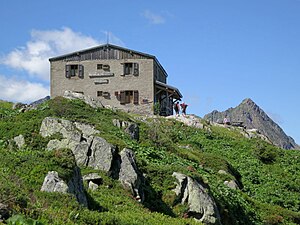
Refuge Robert Blanc
Distance: Approx. 7170 meters
Latitude and longitude: 45.76555556,6.77416667
Refuge Robert Blanc is a refuge in the Alps at an altitude of 2,750 m, located on the route of the Tour du Mont Blanc.
Refuge de Tré la Tête
Mountain hut in the French Alps
Distance: Approx. 3335 meters
Latitude and longitude: 45.79194444,6.73472222
Refuge de Tré la Tête is a refuge in the Mont Blanc massif in the Alps.

Aiguille Croche
Mountain in Italy
Distance: Approx. 5891 meters
Latitude and longitude: 45.80027778,6.65916667
The Aiguille Croche (2,487 metres (8,159 ft)) is a mountain in the Beaufortain Massif in Savoie and Haute-Savoie, France. In 2009, Matthias Giraud was the first person to descent and ski BASE jump off its cliff face.

Mont d'Arbois
Mountain in France
Distance: Approx. 5889 meters
Latitude and longitude: 45.85472222,6.66944444
Mont d'Arbois is a mountain of Haute-Savoie, France. It lies in the Beaufortain Massif range, at an altitude of 1833 metres above sea level.

Mont Tondu
Mountain in Savoie, France
Distance: Approx. 6778 meters
Latitude and longitude: 45.76361111,6.75527778
Mont Tondu is a mountain of Savoie, France. It lies in the Mont Blanc massif and has an elevation of 3,196 metres (10,486 ft) above sea level.

Mont Joly
Distance: Approx. 2822 meters
Latitude and longitude: 45.82583333,6.69277778
Mont Joly (2,525 m) is a mountain in the Beaufortain Massif in Haute-Savoie, France.
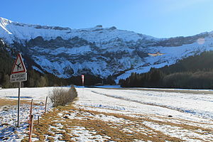
Megève Altiport
Airport
Distance: Approx. 6170 meters
Latitude and longitude: 45.82361111,6.64916667
Megève Altiport (French: Altiport de Megève, IATA: MVV, ICAO: LFHM) is an altiport 5 km (3 miles) southeast of Megève, a commune in the Haute-Savoie department of the Rhône-Alpes region in eastern France.

Dômes de Miage
Line of mountain peaks in the Mont Blanc massif
Distance: Approx. 5573 meters
Latitude and longitude: 45.81583,6.8
The Dômes de Miage are a line of mountain peaks in the south of the Mont Blanc massif that reach a height of 3,673 metres. The snow-covered arête from which they rise is over three kilometres long. The six peaks in the chain are (from southwest to northeast) : L'Aiguille de la Bérangère (3,425 m), and unnamed tops known only from their heights as Dôme 3670, Dôme 3666, Dôme 3633, Dôme 3673 and Dôme 3672.
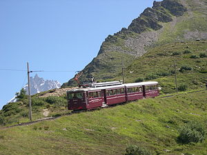
Nid d'Aigle station
Terminus of the Tramway du Mont Blanc
Distance: Approx. 6796 meters
Latitude and longitude: 45.85846,6.79851
Gare du Nid d'Aigle (French: Eagle's Nest Station) is the terminus of the Tramway du Mont Blanc (TMB) from Saint-Gervais-les-Bains on the slopes of the Mont Blanc. This station welcomes mountaineers as well as hikers at 2,362 m altitude below the glacier of Bionnassay. During the winter months the tram only stops at the lower Bellevue station, because of the avalanche risks.
Weather in this IP's area
light rain
15 Celsius
15 Celsius
15 Celsius
15 Celsius
1013 hPa
75 %
1013 hPa
886 hPa
10000 meters
0.99 m/s
1.9 m/s
153 degree
100 %
07:03:08
19:58:34