Country:
 France
Region:
City:
Latitude and Longitude:
Time Zone:
Postal Code:
IP information under different IP Channel
ip-api
Country
Region
City
ASN
Time Zone
ISP
Blacklist
Proxy
Latitude
Longitude
Postal
Route
IPinfo
Country
Region
City
ASN
Time Zone
ISP
Blacklist
Proxy
Latitude
Longitude
Postal
Route
MaxMind
Country
Region
City
ASN
Time Zone
ISP
Blacklist
Proxy
Latitude
Longitude
Postal
Route
Luminati
Country
FRASN
Time Zone
Europe/Paris
ISP
ADISTA SAS
Latitude
Longitude
Postal
db-ip
Country
Region
City
ASN
Time Zone
ISP
Blacklist
Proxy
Latitude
Longitude
Postal
Route
ipdata
Country
Region
City
ASN
Time Zone
ISP
Blacklist
Proxy
Latitude
Longitude
Postal
Route
Popular places and events near this IP address

Capcir
Distance: Approx. 5470 meters
Latitude and longitude: 42.61666667,2.11666667
Capcir (Catalan: [kəpˈsi]; French: [kapsiʁ]) is a historical Catalan comarca of Northern Catalonia, now part of the French department of Pyrénées-Orientales. The capital of the comarca was Formiguera, and it borders the historical comarques of Conflent and Alta Cerdanya. Capcir is on a plateau, averaging 1500 metres above sea level, and allows passage between the high valleys of Aude and both the Spanish Cerdanya and French Cerdagne.

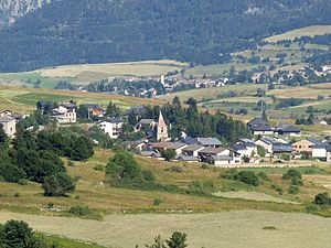
Formiguères
Commune in Occitania, France
Distance: Approx. 4722 meters
Latitude and longitude: 42.6156,2.1025
Formiguères (French pronunciation: [fɔʁmiɡɛʁ] ; Catalan: Formiguera) is a commune in the Pyrénées-Orientales department in southern France. Its inhabitants are called Formiguérois.
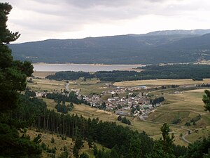
Matemale
Commune in Occitania, France
Distance: Approx. 3802 meters
Latitude and longitude: 42.5878,2.1194
Matemale (French pronunciation: [matmal] ; Catalan: Matamala) is a commune in the Pyrénées-Orientales department in southern France.

Fontrabiouse
Commune in Occitania, France
Distance: Approx. 6755 meters
Latitude and longitude: 42.6369,2.0967
Fontrabiouse (French pronunciation: [fɔ̃ʁabjuz] ; Catalan: Font-rabiosa) is a commune in the Pyrénées-Orientales department in southern France.
Bolquère
Commune in Occitania, France
Distance: Approx. 8297 meters
Latitude and longitude: 42.5039,2.0778
Bolquère (French pronunciation: [bɔlkɛʁ] ; Catalan: Bolquera) is a commune in the Pyrénées-Orientales department in southern France.

Caudiès-de-Conflent
Commune in Occitania, France
Distance: Approx. 7232 meters
Latitude and longitude: 42.5681,2.1619
Caudiès-de-Conflent (French pronunciation: [kodjɛs də kɔ̃flɑ̃] , literally Caudiès of Conflent; Catalan: Caudiers de Conflent) is a commune in the Pyrénées-Orientales department in southern France.

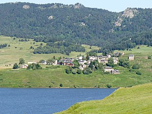
Réal
Commune in Occitania, France
Distance: Approx. 7659 meters
Latitude and longitude: 42.6314,2.1344
Réal (French pronunciation: [ʁeal] ; Catalan: Real) is a commune in the Pyrénées-Orientales department in southern France.

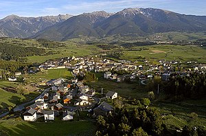
Les Angles, Pyrénées-Orientales
Commune in Occitania, France
Distance: Approx. 20 meters
Latitude and longitude: 42.5783,2.075
Les Angles (French pronunciation: [le.z‿ɑ̃ɡl] ; Catalan: Els Angles, Catalan pronunciation: [əlz ˈaŋɡləs]) is a commune in the Pyrénées-Orientales department in southern France. Legend has it that at the beginning of the XIV century, the Black Death wiped out the entire population of the former village of Vallsera. Only two sisters survived, they are believed to have donated all of the land to the commune of Les Angles.
Puyvalador
Commune in Occitania, France
Distance: Approx. 8529 meters
Latitude and longitude: 42.6472,2.1206
Puyvalador (French pronunciation: [pɥivaladɔʁ] ; Catalan: Puigbalador) is a commune in the Pyrénées-Orientales department in southern France.
La Llagonne
Commune in Occitania, France
Distance: Approx. 6876 meters
Latitude and longitude: 42.5272,2.1217
La Llagonne (French: [la jagɔn] ; Catalan: La Llaguna) is a commune in the Pyrénées-Orientales department in southern France.

Canton of Mont-Louis
Distance: Approx. 8578 meters
Latitude and longitude: 42.5092,2.1208
The Canton of Mont-Louis is a French former canton of the Pyrénées-Orientales department, in the Languedoc-Roussillon region. It had 3,970 inhabitants (2012). It was disbanded following the French canton reorganisation which came into effect in March 2015.

Col de la Quillane
Distance: Approx. 4672 meters
Latitude and longitude: 42.54805556,2.11416667
Col de la Quillane is a mountain pass in the Pyrenees on the border between La Llagonne and Matemale in Pyrénées-Orientales. The Col de la Quillane marks the boundary of the watershed, with the Aude river on one side and the Têt river on the other. It is from the Col de la Quillane that the businessman and Pyrenees explorer Prosper Auriol, and his friends, made the first skiing ever in the Pyrenees, on 29 January 1901.
Weather in this IP's area
overcast clouds
4 Celsius
4 Celsius
2 Celsius
4 Celsius
1020 hPa
85 %
1020 hPa
835 hPa
4477 meters
1.33 m/s
2.74 m/s
308 degree
100 %
08:09:36
19:03:17