Country:
 France
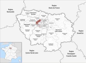
Region:
City:
Latitude and Longitude:
Time Zone:
Postal Code:
IP information under different IP Channel
ip-api
Country
Region
City
ASN
Time Zone
ISP
Blacklist
Proxy
Latitude
Longitude
Postal
Route
IPinfo
Country
Region
City
ASN
Time Zone
ISP
Blacklist
Proxy
Latitude
Longitude
Postal
Route
MaxMind
Country
Region
City
ASN
Time Zone
ISP
Blacklist
Proxy
Latitude
Longitude
Postal
Route
Luminati
Country
FRRegion
idf
City
nanterre
ASN
Time Zone
Europe/Paris
ISP
ADISTA SAS
Latitude
Longitude
Postal
db-ip
Country
Region
City
ASN
Time Zone
ISP
Blacklist
Proxy
Latitude
Longitude
Postal
Route
ipdata
Country
Region
City
ASN
Time Zone
ISP
Blacklist
Proxy
Latitude
Longitude
Postal
Route
Popular places and events near this IP address

Nanterre-Université station
Railway station in Nanterre, France
Distance: Approx. 1233 meters
Latitude and longitude: 48.90138889,2.21472222
Nanterre-Université station is a French railway station on the line from Paris-Saint-Lazare to Saint-Germain-en-Laye, located in the commune of Nanterre. It takes its name from the fact that it is located next to the campus of the Paris Nanterre University. The station is served by trains from Line A of the Réseau Express Régional traveling on the A1 branch to Saint-Germain-en-Laye, as well as by Line L of the Transilien Paris-Saint-Lazare network on the branch to Cergy-le-Haut.
Arrondissement of Nanterre
Arrondissement in Île-de-France, France
Distance: Approx. 589 meters
Latitude and longitude: 48.89444444,2.20333333
The arrondissement of Nanterre is an arrondissement of France in the Hauts-de-Seine department in the Île-de-France region. It has 17 communes. Its population is 900,667 (2019), and its area is 91.8 km2 (35.4 sq mi).
Préfecture des Hauts-de-Seine
Administrative building located in Nanterre
Distance: Approx. 851 meters
Latitude and longitude: 48.89722222,2.21583333
The Préfecture des Hauts-de-Seine is an administrative building located in Nanterre, in the inner suburbs of Paris, France. Designed specifically to host the administrative offices of the préfecture of the Hauts-de-Seine département, the building has a wide base below its 113 m (371 ft)-tall tower.

Nanterre Cathedral
Distance: Approx. 965 meters
Latitude and longitude: 48.89083333,2.19611111
Nanterre Cathedral (French: Cathédrale Sainte-Geneviève-et-Saint-Maurice de Nanterre) is a Roman Catholic church located in the town of Nanterre, France. The cathedral is the seat of the Bishop of Nanterre. Formerly Nanterre Parish Church, it became the Nanterre Cathedral after the establishment of the diocese in 1966.
Nanterre massacre
2002 mass shooting in Nanterre, France
Distance: Approx. 306 meters
Latitude and longitude: 48.8923,2.2057
The Nanterre massacre was a mass murder that occurred on 27 March 2002, in Nanterre, France. Gunman Richard Durn opened fire at the end of a town council meeting, resulting in the deaths of eight councillors and the injury of nineteen others. Durn committed suicide the following day, by leaping from a police station window during questioning.

Nanterre-Ville station
Railway station in Nanterre, France
Distance: Approx. 1105 meters
Latitude and longitude: 48.8952,2.19569
Nanterre-Ville station is a railway station in Nanterre on the A1 branch on Line A of the Réseau Express Régional system. Trains come every 10 minutes and the area is about 12 minutes ride from La Defense business district and about 18 minutes from the Arc de Triomphe.
Roman Catholic Diocese of Nanterre
Catholic diocese in France
Distance: Approx. 988 meters
Latitude and longitude: 48.8907,2.1958
The Diocese of Nanterre (Latin: Dioecesis Nemptodurensis; French: Diocèse de Nanterre) is a Latin diocese of the Catholic Church in France. Erected in 1966, the diocese was split off from the Diocese of Versailles and the Archdiocese of Paris. Currently the diocese remains a suffragan of the Archdiocese of Paris.

Nanterre-Préfecture station
RER train station in the commune of Nanterre, France
Distance: Approx. 1142 meters
Latitude and longitude: 48.895631,2.223138
Nanterre–Préfecture station is a RER train station in the commune of Nanterre, west of central Paris, in the department of Hauts-de-Seine in France. The station was opened on 1 October 1973, on the "ligne de St-Germain" connecting Auber and Saint-Germain-en-Laye. It is the westernmost station of the central trunk segment of the RER A. The line splits at this station into multiple branches headed westward; the A1 (to Saint-Germain-en-Laye) and the A3 and A5 branches (to Cergy-le-Haut and Poissy) respectively.
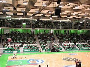
Palais des Sports Maurice Thorez
Indoor sports arena
Distance: Approx. 220 meters
Latitude and longitude: 48.8927441,2.2103631
Palais des Sports Maurice Thorez, or Palais des Sports de Nanterre, is an indoor sporting arena that is located in Nanterre, Hauts-de-Seine, France, near Paris. The arena is named after former minister Maurice Thorez. The capacity of the arena for basketball games is 3,000.
Canton of Nanterre-1
Administrative division of Hauts-de-Seine, France
Distance: Approx. 1220 meters
Latitude and longitude: 48.9,2.2
The canton of Nanterre-1 is an administrative division of the Hauts-de-Seine department, in northern France. It was created at the French canton reorganisation which came into effect in March 2015. Its seat is in Nanterre.
Canton of Nanterre-2
Administrative division of Hauts-de-Seine, France
Distance: Approx. 113 meters
Latitude and longitude: 48.89,2.21
The canton of Nanterre-2 is an administrative division of the Hauts-de-Seine department, in northern France. It was created at the French canton reorganisation which came into effect in March 2015. Its seat is in Nanterre.
Killing of Nahel Merzouk
2023 police shooting in France
Distance: Approx. 1219 meters
Latitude and longitude: 48.8985,2.2213
On 27 June 2023, Nahel Merzouk (25 February 2006 – 27 June 2023), a 17-year-old French youth of Moroccan and Algerian descent, was shot at point-blank range and killed by police officer Florian M., when he didn't comply with a request to turn off ignition and attempted to drive away in Nanterre, a suburb of Paris, France. Initial reporting on the incident (informed by police statements) was later contradicted by a video posted online, which led to widespread protests and riots. Symbols of the state such as town halls, schools, police stations, and other buildings were attacked.
Weather in this IP's area
overcast clouds
16 Celsius
15 Celsius
14 Celsius
17 Celsius
1026 hPa
79 %
1026 hPa
1020 hPa
10000 meters
5.14 m/s
20 degree
100 %
07:31:00
20:00:19