Country:
 Belgium
Region:
City:
Latitude and Longitude:
Time Zone:
Postal Code:
IP information under different IP Channel
ip-api
Country
Region
City
ASN
Time Zone
ISP
Blacklist
Proxy
Latitude
Longitude
Postal
Route
IPinfo
Country
Region
City
ASN
Time Zone
ISP
Blacklist
Proxy
Latitude
Longitude
Postal
Route
MaxMind
Country
Region
City
ASN
Time Zone
ISP
Blacklist
Proxy
Latitude
Longitude
Postal
Route
Luminati
Country
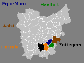
BERegion
vlg
City
erembodegem
ASN
Time Zone
Europe/Brussels
ISP
Opgroeien regie
Latitude
Longitude
Postal
db-ip
Country
Region
City
ASN
Time Zone
ISP
Blacklist
Proxy
Latitude
Longitude
Postal
Route
ipdata
Country
Region
City
ASN
Time Zone
ISP
Blacklist
Proxy
Latitude
Longitude
Postal
Route
Popular places and events near this IP address

Aalst, Belgium
Municipality in Flemish Community, Belgium
Distance: Approx. 1908 meters
Latitude and longitude: 50.93833333,4.03916667
Aalst (Dutch pronunciation: [aːlst] ; French: Alost, pronounced [alɔst]; Brabantian: Oilsjt) is a city and municipality in the province of East Flanders in the Flemish Region of Belgium. It is located on the Dender River, about 31 kilometres (19 mi) northwest of Brussels. The municipality comprises the city of Aalst itself and the villages of Baardegem, Erembodegem, Gijzegem, Herdersem, Hofstade, Meldert, Moorsel and Nieuwerkerken; it is the tenth largest city by population with 90.068 inhabitants.

Schepenhuis, Aalst
Distance: Approx. 1917 meters
Latitude and longitude: 50.93833333,4.03888889
The Schepenhuis (Aldermen's House) of Aalst, East Flanders, Belgium, is a former city hall, one of the oldest in the Low Countries. Dating originally from 1225, it was partially rebuilt twice as a result of fire damage, first after a 1380 war and again after a fireworks accident in 1879. The belfry tower at one corner of the building was completed in 1460, and in the next year was equipped with a carillon built by master craftsmen from Mechelen.
Molenbeek-Ter Erpenbeek
Brook from Godveerdegem to Hofstade, Belgium
Distance: Approx. 3803 meters
Latitude and longitude: 50.9549,4.032
The Molenbeek-Ter Erpenbeek or in popular language Molenbeek (English: Millbrook-Ter Erpenbrook) is a brook in the Denderstreek region of Belgium. The stream has a length of approximately 25 kilometers. The source of the Molenbeek is in Godveerdegem and the delta is located at Hofstade.
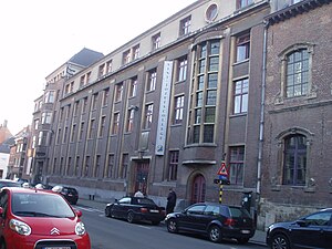
St Joseph College, Aalst
Secondary school in Aalst, Belgium
Distance: Approx. 1730 meters
Latitude and longitude: 50.937188,4.041308
St Joseph's College (Dutch, Sint-Jozefscollege) is a Roman Catholic subsidized free school for general secondary education founded by the Society of Jesus in Aalst. The school building is a protected monument.
Okapi Forum
Multi-purpose arena in Aalst, Belgium
Distance: Approx. 1899 meters
Latitude and longitude: 50.9398,4.0547
Okapi Forum is a multi-purpose arena in Aalst, Belgium. Okapi Forum holds room for 2,800 people for basketball games. It hosts the home games of the BNXT League club Okapi Aalst, as well as performances of music artists.

Aalst railway station
Railway station in East Flanders, Belgium
Distance: Approx. 2685 meters
Latitude and longitude: 50.94583333,4.03916667
Aalst railway station (Dutch: Station Aalst; French: Gare d'Alost) is a railway station in Aalst, East Flanders, Belgium. The station opened on 9 June 1853 and is located on railway lines 50 and 82. The train services are operated by the National Railway Company of Belgium (NMBS/SNCB).

Denderleeuw railway station
Railway station in East Flanders, Belgium
Distance: Approx. 3775 meters
Latitude and longitude: 50.89166667,4.07194444
Denderleeuw railway station (Dutch: Station Denderleeuw; French: Gare de Denderleeuw) is a railway station in Denderleeuw, East Flanders, Belgium. The station opened on 7 April 1855 and is located on railway lines 50, 89 and 90. The train services are operated by the National Railway Company of Belgium (NMBS/SNCB).

Ninove Abbey
Church in Ninove, Belgium
Distance: Approx. 3352 meters
Latitude and longitude: 50.9,4.02
Ninove Abbey (Dutch: Abdij van Sint-Cornelius en Sint-Cyprianus) was a monastery of the Premonstratensian Order in the center of Ninove, in the province of East Flanders, Belgium. Only the abbey church now remains. The parish church at Ninove was converted into a Premonstratensian Abbey in 1137 by Gerard I, Lord of Ninove, in remembrance of his wife Gisela and himself.

Grote Markt, Aalst
Square in Aalst, Belgium
Distance: Approx. 1917 meters
Latitude and longitude: 50.93833333,4.03888889
The Grote Markt (Dutch, pronounced [ˌɣroːtə ˈmɑr(ə)kt] , Aalsters: Groeite Mert; meaning "Big Market") is the central square of Aalst, East Flanders, Belgium. The Schepenhuis (Aldermen's House), the Town Hall, the Beurs van Amsterdam and the Herberg Graaf van Egmont are located there. The Grote Markt is an UNESCO buffer zone as well, thanks to the Schepenhuis.

Groot Park
City Park of the city of Aalst.
Distance: Approx. 890 meters
Latitude and longitude: 50.93032,4.046294
The Groot park or Park schepen de Wolf or city park of Aalst (stadspark) is a park in the Belgian city of Aalst. It can be regarded as an artificial nature domain with a recreational-educational function. The park covers an area of approximately 15 hectares (37 acres).

Saint-Joseph Church (Aalst)
Church in Belgium
Distance: Approx. 2309 meters
Latitude and longitude: 50.9411,4.0352
The Saint-Joseph Church (Dutch: Sint-Jozefkerk) is a neo-Gothic church with basilical construction, located in the Belgian city of Aalst (province of East Flanders). Work on the church started in 1868 and was completed in 1908. The future of the church is currently uncertain due to serious stability problems however in 2023 it was decided to restore the building.

Onze-Lieve-Vrouw van Meuleschettekapel
Distance: Approx. 2434 meters
Latitude and longitude: 50.94076,4.03098
Onze-Lieve-Vrouw van Meuleschettekapel, also known as The Meuleschettekapel, is a chapel in the Dirk Martensstraat in Aalst, Belgium. It was designed by Jules Goethals in 1894.
Weather in this IP's area
overcast clouds
12 Celsius
12 Celsius
12 Celsius
13 Celsius
1007 hPa
85 %
1007 hPa
1006 hPa
10000 meters
8.7 m/s
14.07 m/s
243 degree
90 %
07:44:31
19:22:02