Country:
 Czech Republic
Region:
City:
Latitude and Longitude:
Time Zone:
Postal Code:
IP information under different IP Channel
ip-api
Country
Region
City
ASN
Time Zone
ISP
Blacklist
Proxy
Latitude
Longitude
Postal
Route
IPinfo
Country
Region
City
ASN
Time Zone
ISP
Blacklist
Proxy
Latitude
Longitude
Postal
Route
MaxMind
Country
Region
City
ASN
Time Zone
ISP
Blacklist
Proxy
Latitude
Longitude
Postal
Route
Luminati
Country
CZRegion
51
City
liberec
ASN
Time Zone
Europe/Prague
ISP
Freenet Liberec, z.s.
Latitude
Longitude
Postal
db-ip
Country
Region
City
ASN
Time Zone
ISP
Blacklist
Proxy
Latitude
Longitude
Postal
Route
ipdata
Country
Region
City
ASN
Time Zone
ISP
Blacklist
Proxy
Latitude
Longitude
Postal
Route
Popular places and events near this IP address

Battle of Reichenberg
1757 battle of the Third Silesian War
Distance: Approx. 5607 meters
Latitude and longitude: 50.767,15.0561
The Battle of Reichenberg took place during the Third Silesian War (part of the Seven Years' War) on 21 April 1757 near the town of Reichenberg (Czech: Liberec) in Bohemia.
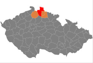
Liberec District
District in Liberec, Czech Republic
Distance: Approx. 4824 meters
Latitude and longitude: 50.83333333,15.05
Liberec District (Czech: okres Liberec) is a district in the Liberec Region of the Czech Republic. Its capital is the city of Liberec.

Stadion u Nisy
Distance: Approx. 4597 meters
Latitude and longitude: 50.77611111,15.05
Stadion u Nisy is an all-seater football stadium in Liberec. The stadium is home to Czech football club Slovan Liberec and occasionally hosts matches of the Czech Republic national team. The stadium is named after the river Nisa, flowing directly behind the North Stand.

Chrastava
Town in the Czech Republic
Distance: Approx. 2711 meters
Latitude and longitude: 50.81694444,14.96888889
Chrastava (Czech pronunciation: [ˈxrastava]; German: Kratzau) is a town in Liberec District in the Liberec Region of the Czech Republic. It has about 6,300 inhabitants.
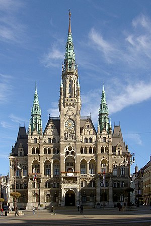
Liberec City Hall
Building in Liberec, Czech Republic
Distance: Approx. 5508 meters
Latitude and longitude: 50.76972222,15.05833333
Liberec City Hall (Czech: Liberecká radnice) is a large building in Liberec in the Czech Republic.

Machnín
Village in Liberec, Czech Republic
Distance: Approx. 1516 meters
Latitude and longitude: 50.79083333,14.99166667
Machnín (German: Machendorf), officially Liberec XXXIII-Machnín, is a village and administrative part of the city of Liberec in the Czech Republic.
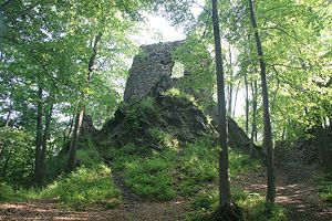
Hamrštejn
Ruined castle in Czech Republic
Distance: Approx. 2806 meters
Latitude and longitude: 50.7866,14.9707
Hamrštějn (German: Hammerstein) is a castle ruin located close to the city of Liberec, Czech Republic.

Nová Ves (Liberec District)
Municipality in Liberec, Czech Republic
Distance: Approx. 3169 meters
Latitude and longitude: 50.83166667,15.00111111
Nová Ves (German: Neundorf) is a municipality and village in Liberec District in the Liberec Region of the Czech Republic. It has about 900 inhabitants.

Battle of Kratzau
Distance: Approx. 1121 meters
Latitude and longitude: 50.79333333,14.9975
The Battle of Kratzau occurred on 11 November 1428 between an Imperial Silesian army and the Sirotci Hussites in Kratzau, Bohemia. During the battle, the Imperial Silesian army under Hans von Polenz overpowered the Hussite troops. In November 1428, the Hussites under the leadership of Jan Královec launched a campaign from the occupied Kratzau of Friedland and Ostritz to Löbau.

Mníšek
Municipality in Liberec, Czech Republic
Distance: Approx. 5038 meters
Latitude and longitude: 50.83166667,15.05638889
Mníšek (German: Einsiedel in Isergebirge) is municipality and village in Liberec District in the Liberec Region of the Czech Republic. It has about 1,800 inhabitants.

Stráž nad Nisou
Municipality in Liberec, Czech Republic
Distance: Approx. 2285 meters
Latitude and longitude: 50.79111111,15.02694444
Stráž nad Nisou (until 1947 Starý Habendorf; German: Althabendorf) is a municipality and village in Liberec District in the Liberec Region of the Czech Republic. It has about 2,400 inhabitants. The municipality forms an enclave in the territory of Liberec.
Liberec Speedway
Czech motorcycle speedway team
Distance: Approx. 3698 meters
Latitude and longitude: 50.78359167,15.04311667
Liberec Speedway is the motorcycle speedway club known as Plochá dráha klub v AČR Liberec and the Pavlovický Stadion, which hosts the club. The stadium is located in the northern outskirts of Liberec in the Czech Republic, off the Letná 618.
Weather in this IP's area
overcast clouds
15 Celsius
15 Celsius
15 Celsius
16 Celsius
1019 hPa
98 %
1019 hPa
971 hPa
10000 meters
2.16 m/s
3.48 m/s
5 degree
100 %
06:38:54
19:10:06