Country:
Region:
City:
Latitude and Longitude:
Time Zone:
Postal Code:
IP information under different IP Channel
ip-api
Country
Region
City
ASN
Time Zone
ISP
Blacklist
Proxy
Latitude
Longitude
Postal
Route
Luminati
Country
ASN
Time Zone
Europe/Berlin
ISP
IT Heinrich GmbH
Latitude
Longitude
Postal
IPinfo
Country
Region
City
ASN
Time Zone
ISP
Blacklist
Proxy
Latitude
Longitude
Postal
Route
db-ip
Country
Region
City
ASN
Time Zone
ISP
Blacklist
Proxy
Latitude
Longitude
Postal
Route
ipdata
Country
Region
City
ASN
Time Zone
ISP
Blacklist
Proxy
Latitude
Longitude
Postal
Route
Popular places and events near this IP address

Bannewitz
Municipality in Saxony, Germany
Distance: Approx. 3268 meters
Latitude and longitude: 50.99305556,13.71666667
Bannewitz is a municipality in the Sächsische Schweiz-Osterzgebirge district, in Saxony, Germany. It is situated 7 km (4 mi) south of Dresden (centre).

Rabenau, Saxony
Town in Saxony, Germany
Distance: Approx. 3501 meters
Latitude and longitude: 50.96666667,13.63333333
Rabenau () is a town in the Sächsische Schweiz-Osterzgebirge district, in the Free State of Saxony, Germany. It is situated 8 kilometres (5.0 mi) north of Dippoldiswalde, and 12 kilometres (7.5 mi) southwest of Dresden (centre).

Red Weißeritz
River in Germany
Distance: Approx. 2965 meters
Latitude and longitude: 50.9816,13.6296
The Red Weißeritz (German: Rote Weißeritz) is a river of Saxony, Germany. The Red Weißeritz is the right headstream of the Weißeritz. It is 36.5 km (22.7 mi) long.

Wild Weißeritz
River in the Czech Republic and in Germany
Distance: Approx. 2974 meters
Latitude and longitude: 50.98166667,13.62944444
The Wild Weißeritz (German: Wilde Weißeritz, Czech: Divoká Bystřice) is a river in the Czech Republic and in the German state of Saxony which drains the eastern Ore Mountains. It is the longest tributary of the Weißeritz. The valley of the Wild Weißeritz is almost free of settlements.

Deuben (Freital)
Distance: Approx. 2183 meters
Latitude and longitude: 50.99972222,13.64666667
Deuben is a municipal subdivision of Freital in Sächsische Schweiz-Osterzgebirge district.

Gohlig
Distance: Approx. 3421 meters
Latitude and longitude: 50.98277778,13.71916667
Gohlig is a mountain of Saxony, southeastern Germany.

Döhlen Basin
Distance: Approx. 2268 meters
Latitude and longitude: 51.00187,13.64811
The Döhlen Basin (German: Döhlener Becken) is a landscape unit in the German federal state of Saxony, southwest of Dresden. The Döhlen Basin has a length of 22 km and a width of 6 km and lies within the district of Sächsische Schweiz-Osterzgebirge.
Windberg (Freital)
Distance: Approx. 1275 meters
Latitude and longitude: 50.99694,13.66083
The Windberg (353 m above NN) is a hill in the borough of Freital near Dresden in the German federal state of Saxony. It is the town's Hausberg or local hill.
Wiederitz
River in Germany
Distance: Approx. 2556 meters
Latitude and longitude: 51.0097,13.6622
The Wiederitz is a river of Saxony, Germany. It is a left tributary of the Weißeritz, which it joins in Freital.

Birkigt (Freital)
Distance: Approx. 2725 meters
Latitude and longitude: 51.01111111,13.68055556
Birkigt is a district in Freital, a town in Sächsische Schweiz-Osterzgebirge, Saxony, Germany. Formerly an independent municipality, it was absorbed by Freital in 1923.
Freital-Hainsberg station
Railway station in Freital, Germany
Distance: Approx. 2338 meters
Latitude and longitude: 50.9887,13.6376
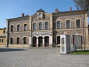
Freital-Hainsberg station is a station on the Dresden–Werdau railway in the district of Hainsberg of the municipality of Freital in the German state of Saxony. The Weißeritz Valley Railway branches off to Kipsdorf from the station. Since 31 May 1992, the station has been served by the Dresden S-Bahn.
Freital-Potschappel station
Railway station in Freital, Germany
Distance: Approx. 2943 meters
Latitude and longitude: 51.013218,13.661839
Freital-Potschappel station is a station on the Dresden–Werdau railway in the district of Potschappel of the municipality of Freital in the German state of Saxony. From 1884 to 1972, the station was the starting point of the 750 mm gauge Freital-Potschappel–Nossen railway. Today, Freital-Potschappel serves in particular as an access point to line S3 of the Dresden S-Bahn.
Weather in this IP's area
moderate rain
2 Celsius
1 Celsius
1 Celsius
3 Celsius
1008 hPa
79 %
1008 hPa
981 hPa
34 meters
1.86 m/s
4.96 m/s
289 degree
100 %
07:27:04
16:14:19


