185.188.29.223 - IP Lookup: Free IP Address Lookup, Postal Code Lookup, IP Location Lookup, IP ASN, Public IP
Country:
Region:
City:
Location:
Time Zone:
Postal Code:
ISP:
ASN:
language:
User-Agent:
Proxy IP:
Blacklist:
IP information under different IP Channel
ip-api
Country
Region
City
ASN
Time Zone
ISP
Blacklist
Proxy
Latitude
Longitude
Postal
Route
db-ip
Country
Region
City
ASN
Time Zone
ISP
Blacklist
Proxy
Latitude
Longitude
Postal
Route
IPinfo
Country
Region
City
ASN
Time Zone
ISP
Blacklist
Proxy
Latitude
Longitude
Postal
Route
IP2Location
185.188.29.223Country
Region
antalya
City
alanya
Time Zone
Europe/Istanbul
ISP
Language
User-Agent
Latitude
Longitude
Postal
ipdata
Country
Region
City
ASN
Time Zone
ISP
Blacklist
Proxy
Latitude
Longitude
Postal
Route
Popular places and events near this IP address
Alanya
District and municipality in Antalya, Turkey
Distance: Approx. 690 meters
Latitude and longitude: 36.55,32
Alanya ( ; Turkish pronunciation: [aˈɫanja]), formerly Alaiye, is a beach resort city, a municipality and district of Antalya Province, Turkey. It is on the southern coast of Turkey, in the country's Mediterranean Region, 133 kilometres (83 mi) east of the city of Antalya. Its area is 1,577 km2, and its population is 364,180 (2022).

Red Tower (Alanya)
Tower in Alanya, Turkey
Distance: Approx. 828 meters
Latitude and longitude: 36.53651,31.99797
The Red Tower (Turkish: Kızıl Kule) is a historical tower in the Turkish city of Alanya. The building is considered to be the symbol of the city, and is used on the city's flag.

Alaiye
City-state in Anatolia from 1293 to 1471
Distance: Approx. 256 meters
Latitude and longitude: 36.545669,31.99813
Alaiye (علائیه) is the medieval Seljuq name for Alanya (on the southern coast of Turkey). It refers to the city-state in a specific period and the beylik which developed around there, at times under the Karamanid dynasty. After the 1242 Battle of Köse Dağ, the Seljuqs lost control of the city, and it became semi-autonomous.

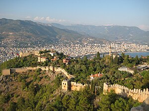
Alanya Castle
Castle in Alanya, Turkey
Distance: Approx. 1430 meters
Latitude and longitude: 36.53321,31.99076
Alanya Castle (Alanya Kalesi) is a medieval castle in the southern Turkish city of Alanya.
Battle of Korakesion
Naval battle
Distance: Approx. 1787 meters
Latitude and longitude: 36.53,32.01
The Battle of Korakesion, also known as the Battle of Coracaesium, was a naval battle fought in 67 BC between the Cilician Pirates and the Roman Republic. It was the culmination of Pompey the Great's campaign against the pirates of the Mediterranean; Plutarch describes it as the key battle of Pompey's clearing of the Mediterranean of pirates after several smaller battles. According to Plutarch the pirates had about a thousand ships (almost certainly an exaggeration) against Pompey's two hundred, but were defeated in the initial naval engagement.
McGhee Center for Eastern Mediterranean Studies
Academic center operated by Georgetown University
Distance: Approx. 1177 meters
Latitude and longitude: 36.53372222,31.99583333
The McGhee Center for Eastern Mediterranean Studies was an overseas academic center operated by Georgetown University, in Alanya, Turkey. The McGhee Center was founded in 1989 after Ambassador George Crews McGhee, former United States Ambassador to Turkey and West Germany, donated his Mediterranean villa to Georgetown University to create a center for the study of the history and culture of Turkey and the Eastern Mediterranean. The McGhee Center was academically affiliated with Koç University and offered three types of programming: semester abroad, the Summer Institute in Intensive Turkish Language, and study tours and short programs.
Başkent University Medical and Research Center of Alanya
Hospital in Alanya, Turkey
Distance: Approx. 631 meters
Latitude and longitude: 36.54719,31.99415
Başkent University Medical and Research Center of Alanya is a medical and research center in Alanya, Turkey. It is one of the Başkent University hospitals in Turkey. The center was opened on 10 July 2000.
Çarşı, Beşiktaş
Distance: Approx. 1165 meters
Latitude and longitude: 36.53333333,32
Çarşı (English: Marketplace), is geographically the center of the Beşiktaş municipality, a district on the European side of central Istanbul. The area is notable for being dominated by winding narrow streets that date to city's earliest ancient Hellenic roots. As one of the main commercial districts of Istanbul, the Çarşı is known for its restaurants, meyhanes (pubs), döner stores, cafés, bakeries, patisseries, internet cafés and garment shops.
Cikcilli, Alanya
Neighbourhood in Alanya, Antalya, Turkey
Distance: Approx. 3077 meters
Latitude and longitude: 36.55,32.03333333
Cikcilli is a neighbourhood in the municipality and district of Alanya, Antalya Province, Turkey. Its population is 21,449 (2022). Before the 2013 reorganisation, it was a town (belde).
Hacımehmetli, Alanya
Neighbourhood in Alanya, Antalya, Turkey
Distance: Approx. 3872 meters
Latitude and longitude: 36.5675,31.9681
Hacımehmetli is a neighbourhood in the municipality and district of Alanya, Antalya Province, Turkey. Its population is 2,144 (2022).
Kazim Bulut Mosque
Mosque in Alanya, Antalya, Turkey
Distance: Approx. 981 meters
Latitude and longitude: 36.55,31.992
The Kazim Bulut Mosque (Turkish: Kazım Bulut Camii) is a mosque in Turkey situated in the city of Alanya in the province of Antalya Province.

Alanya Archaeological Museum
Archaeological museum in Alanya, Turkey
Distance: Approx. 984 meters
Latitude and longitude: 36.54397,31.9888
Alanya Archaeological Museum is an archaeological museum in Alanya, Turkey. The museum is divided into two sections, with displays of archaeological and ethnographic artifacts. It contains numerous ceramic, marble, bronze and glass pieces and mosaics from the Hellenistic, Roman, and Byzantine periods.
Weather in this IP's area
scattered clouds
14 Celsius
13 Celsius
14 Celsius
14 Celsius
1024 hPa
69 %
1024 hPa
1011 hPa
10000 meters
1.89 m/s
1.26 m/s
36 degree
49 %
