Country:
Region:
City:
Latitude and Longitude:
Time Zone:
Postal Code:
IP information under different IP Channel
ip-api
Country
Region
City
ASN
Time Zone
ISP
Blacklist
Proxy
Latitude
Longitude
Postal
Route
Luminati
Country
City
pristina
ASN
Time Zone
Europe/Belgrade
ISP
N.P.SH ISP - Broadcast
Latitude
Longitude
Postal
IPinfo
Country
Region
City
ASN
Time Zone
ISP
Blacklist
Proxy
Latitude
Longitude
Postal
Route
db-ip
Country
Region
City
ASN
Time Zone
ISP
Blacklist
Proxy
Latitude
Longitude
Postal
Route
ipdata
Country
Region
City
ASN
Time Zone
ISP
Blacklist
Proxy
Latitude
Longitude
Postal
Route
Popular places and events near this IP address

Assembly of the Republic of Kosovo
Legislature of the Republic of Kosovo
Distance: Approx. 916 meters
Latitude and longitude: 42.66472222,21.16416667
The Assembly of the Republic of Kosovo (Albanian: Kuvendi i Republikës së Kosovës; Serbian: Скупштина Републике Косово, Skupština Republike Kosovo) or the Kuvendi, is the unicameral legislature of the Republic of Kosovo that is directly elected by the people every four years. It was originally established by the United Nations Interim Administration Mission in Kosovo in 2001 to provide 'provisional, democratic self-government'. On February 17, 2008, representatives of the people of Kosovo unilaterally declared Kosovo's independence and subsequently adopted the Constitution of Kosovo, which came into effect on 15 June 2008.

District of Pristina
District in Kosovo
Distance: Approx. 487 meters
Latitude and longitude: 42.677,21.168
The District of Pristina (Albanian: Rajoni i Prishtinës; Serbian: Приштински округ, Prištinski okrug) is a district in Kosovo. Its seat is the capital city of Pristina. It consists of eight municipalities and 298 villages.
KF Flamurtari
Football club in Kosovo
Distance: Approx. 410 meters
Latitude and longitude: 42.674745,21.171065
KF Flamurtari is a professional football club based in Pristina, Kosovo. It is the second biggest team in Prishtina.

Autonomous Province of Kosovo and Metohija
Territory disputed by Serbia and Kosovo
Distance: Approx. 672 meters
Latitude and longitude: 42.66666667,21.16666667
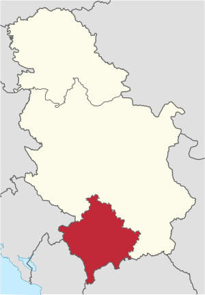
The Autonomous Province of Kosovo and Metohija (Serbian: Косово и Метохиja, romanized: Kosovo i Metohija; Albanian: Kosova dhe Metohia), commonly known as Kosovo (Serbian: Косово; Albanian: Kosova) and abbreviated to Kosmet (from Kosovo and Metohija; Serbian: Космет) or KiM (Serbian: КиМ), is an autonomous province that occupies the southernmost corner of Serbia, as defined by the country's constitution. The territory is the subject of an ongoing political and territorial dispute between the Republic of Serbia and the partially recognised Republic of Kosovo, with the APKM being viewed as the de jure interpretation of the territory under Serbian law; however, the Serbian government currently does not control the territories because they are de facto administered by the Republic of Kosovo. Its claimed administrative capital and largest city is Pristina.
Sami Frashëri High School
Public school in Pristina, Kosovo
Distance: Approx. 509 meters
Latitude and longitude: 42.6683,21.1686
Sami Frashëri High School (Albanian: "Gjimnazi Sami Frashëri") is a selective entry gymnasium with two campuses located on the same street in the Qendër neighborhood of Pristina, Kosovo. The school is highly regarded for academics. The school is among the oldest in Prishtina and Kosovo, and it holds the name of the writer, philosopher, playwright and prominent figure of the Albanian Renaissance Movement, Sami Frashëri.

Bazaar of Pristina
Distance: Approx. 889 meters
Latitude and longitude: 42.665,21.164
The Bazaar of Prishtina (Albanian: Çarshia e Prishtinës; Serbian: Базар у Приштини, romanized: Bazar u Prištini), Kosovo, was the core merchandising center of the Old Prishtina since the 15th century, when it was built. It played a significant role in the physical, economic, and social development of Pristina. The Old Bazaar was destroyed during the 1950s and 1960s, following the modernization slogan of "Destroy the old, build the new".

Great Hammam of Pristina
Ottoman-era monument in Pristina, Kosovo
Distance: Approx. 673 meters
Latitude and longitude: 42.66666667,21.16638889
The Great Hammam of Pristina (Albanian: Hamami i madh i Prishtinës; Serbian: Велики хамам у Приштини / Veliki hamam u Prištini; Turkish: Fatih Sultan Mehmet Han Hamamı) is an Ottoman-era monument in Pristina, Kosovo. It was built in the 15th century and was part of the Imperial Mosque. During the summer and spring, it was used as a meeting place.

Ministry of Education, Science and Technology (Kosovo)
Ministry of the Kosovo government
Distance: Approx. 1074 meters
Latitude and longitude: 42.66305556,21.16638889
The Ministry of Education, Science and Technology (Albanian: Ministria e Arsimit, Shkencës, Teknologjisë dhe Inovacionit) is a department of the government of Kosovo responsible for the policy on education, science and technology of Kosovo.

Jashar Pasha Mosque
Ottoman-era mosque in Prishtina, Kosovo
Distance: Approx. 747 meters
Latitude and longitude: 42.666,21.1664
The Jashar Pasha Mosque is a historical mosque in Prishtina, Kosovo. The mosque was built in 1834 by the mayor of Skopje, Mehmet Yasar.

Skanderbeg Square, Pristina
Public square in Pristina, Kosovo
Distance: Approx. 1044 meters
Latitude and longitude: 42.6636,21.1638
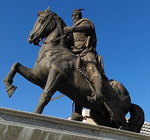
Skanderbeg Square (Albanian: Sheshi "Skënderbeu") is a square in Pristina, Kosovo.
Clock Tower of Pristina
Clock tower in Pristina, Kosovo
Distance: Approx. 664 meters
Latitude and longitude: 42.66674,21.16726
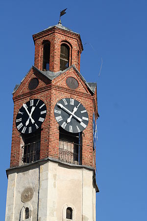
The Clock Tower (Albanian: Sahatkulla) in Pristina, Kosovo, was built in the 19th century by Jashar Pasha, after whom the Mosque is named not far from the Clock Tower. It served as a means of informing the town during the Ottoman Empire rule, in order to let people know when to pray as well as the traders closing their shops. The 26-meter high hexagonal clock tower was made of sandstone and bricks.
Llapi Mosque
Ottoman-era mosque in Pristina, Kosovo
Distance: Approx. 465 meters
Latitude and longitude: 42.67114,21.16163
Llapi Mosque (Albanian: Xhamia e Llapit) is a mosque located in the northern part of the old city center (Old Bazaar) of Prishtina, Kosovo.
Weather in this IP's area
broken clouds
2 Celsius
-2 Celsius
2 Celsius
3 Celsius
1026 hPa
76 %
1026 hPa
954 hPa
10000 meters
5.14 m/s
40 degree
75 %
06:28:33
16:12:01


