Country:
 Netherlands
Region:
City:
Latitude and Longitude:
Time Zone:
Postal Code:
IP information under different IP Channel
ip-api
Country
Region
City
ASN
Time Zone
ISP
Blacklist
Proxy
Latitude
Longitude
Postal
Route
IPinfo
Country
Region
City
ASN
Time Zone
ISP
Blacklist
Proxy
Latitude
Longitude
Postal
Route
MaxMind
Country
Region
City
ASN
Time Zone
ISP
Blacklist
Proxy
Latitude
Longitude
Postal
Route
Luminati
Country
NLASN
Time Zone
Europe/Amsterdam
ISP
BIT BV
Latitude
Longitude
Postal
db-ip
Country
Region
City
ASN
Time Zone
ISP
Blacklist
Proxy
Latitude
Longitude
Postal
Route
ipdata
Country
Region
City
ASN
Time Zone
ISP
Blacklist
Proxy
Latitude
Longitude
Postal
Route
Popular places and events near this IP address

Weurt
Village in Gelderland, Netherlands
Distance: Approx. 3826 meters
Latitude and longitude: 51.85,5.81666667
Weurt is a village in the Dutch province of Gelderland. It is a part of the municipality of Beuningen, and lies about 0.1 km West of Nijmegen. Weurt was a separate municipality until 1818, when it was merged with Beuningen.
Hatert
Suburb in Nijmegen, Gelderland, Netherlands
Distance: Approx. 3587 meters
Latitude and longitude: 51.80833333,5.825
Hatert is a suburb in the south of Nijmegen, in the Netherlands. As of 2021 it has a population of 10.115. It is situated between the centre of Nijmegen and the suburb of Dukenburg.
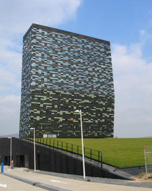
FiftyTwoDegrees
Distance: Approx. 3114 meters
Latitude and longitude: 51.82465278,5.82499167
FiftyTwoDegrees is an 86-metre-tall (282 ft) high-rise building in Nijmegen, Netherlands. It is from a special design. Its lower floors are built as an inclined tower, while its upper sections are from conventional design.

Nijmegen Dukenburg railway station
Railway station in the Netherlands
Distance: Approx. 1033 meters
Latitude and longitude: 51.82388889,5.79472222
Nijmegen Dukenburg is a railway station located in the south west of Nijmegen, Netherlands. The station was opened on 2 June 1973 and is located on the Tilburg–Nijmegen railway. The train services are operated by Nederlandse Spoorwegen.

Goffertpark
Park in the Netherlands
Distance: Approx. 3632 meters
Latitude and longitude: 51.82333333,5.8325
The Goffertpark, or Stadspark de Goffert, is an urban park in the Dutch city of Nijmegen.

Maas–Waal Canal
Distance: Approx. 3879 meters
Latitude and longitude: 51.80027778,5.82055556
The Maas–Waal Canal (Dutch: Maas–Waalkanaal) is a canal in the Netherlands that connects the river Meuse (Dutch: Maas) to the river Waal. The channel is about 13.5 kilometres (8.4 mi) long and runs from Weurt (west of Nijmegen) to the south and ends at Heumen. The connection of the Meuse and the Maas–Waal Canal is the tripoint between the provinces of Gelderland, Limburg and North Brabant.

Wijchen railway station
Railway station in the Netherlands
Distance: Approx. 3759 meters
Latitude and longitude: 51.81111111,5.72944444
Wijchen is a railway station located in Wijchen, Netherlands. The station was opened in 1881 and is located on the Tilburg–Nijmegen railway. The train services are operated by Nederlandse Spoorwegen.

Schoonoord, Alverna
Windmill in Gelderland, Netherlands
Distance: Approx. 3059 meters
Latitude and longitude: 51.80194444,5.75388889
Schoonoord is a tower mill in Alverna, Gelderland, Netherlands, which was built in 1887 and is in working order. The mill is listed as a Rijksmonument.

Nijmegen Goffert railway station
Railway station in Gelderland, Netherlands
Distance: Approx. 3075 meters
Latitude and longitude: 51.82722222,5.82416667
Nijmegen Goffert is a railway station located in the south west of Nijmegen, Netherlands. The station opened on 14 December 2014 and is located on the Tilburg–Nijmegen railway. The train services are operated by Nederlandse Spoorwegen.

Lancaster Memorial (Netherlands)
Monument in Beuningen, Netherlands
Distance: Approx. 3021 meters
Latitude and longitude: 51.846278,5.753972
The Lancaster Memorial in Beuningen, Netherlands is a memorial that commemorates the crew of the British Avro Lancaster LM325 SR-J that crashed on the spot during the night of 22 to 23 June 1943 in World War II. The bomber belonged to the No. 101 Squadron of the RAF. Six of the seven crew lost their lives.

Jonkerbos War Cemetery
WWII CWGC cemetery in Netherlands
Distance: Approx. 3462 meters
Latitude and longitude: 51.8219,5.8299
The Jonkerbos War Cemetery and Memorial is located in the town of Nijmegen, Netherlands. The cemetery contains 1,643 British Commonwealth and foreign service personnel of World War II. It was built to a design by Commission architect Philip Hepworth. On Remembrance Day 2022 (May 4) the cemetery was vandalized with swastikas and other paintings such as the Ukrainian flag and references to Azov.

Alverna, Netherlands
Village in Gelderland, Netherlands
Distance: Approx. 2851 meters
Latitude and longitude: 51.8,5.76666667
Alverna (Dutch pronunciation: [ɑlˈvɛr.naː]) is a village in the municipality of Wijchen in the province of Gelderland in the Netherlands. As of 2021, it had a population of 2,525. The village is named after the Alverna monastery founded there in 1887, which in turn is named after La Verna, the mountain in Tuscany where Francis of Assisi is said to have received the stigmata on 17 September 1224.
Weather in this IP's area
scattered clouds
22 Celsius
22 Celsius
21 Celsius
23 Celsius
1009 hPa
55 %
1009 hPa
1008 hPa
10000 meters
6.17 m/s
200 degree
40 %
07:00:53
20:08:25