Country:
Region:
City:
Latitude and Longitude:
Time Zone:
Postal Code:
IP information under different IP Channel
ip-api
Country
Region
City
ASN
Time Zone
ISP
Blacklist
Proxy
Latitude
Longitude
Postal
Route
Luminati
Country
ASN
Time Zone
Europe/Paris
ISP
GVA-Canalbox
Latitude
Longitude
Postal
IPinfo
Country
Region
City
ASN
Time Zone
ISP
Blacklist
Proxy
Latitude
Longitude
Postal
Route
db-ip
Country
Region
City
ASN
Time Zone
ISP
Blacklist
Proxy
Latitude
Longitude
Postal
Route
ipdata
Country
Region
City
ASN
Time Zone
ISP
Blacklist
Proxy
Latitude
Longitude
Postal
Route
Popular places and events near this IP address
Marcel Sembat station
Metro station in Paris, France
Distance: Approx. 1033 meters
Latitude and longitude: 48.83367,2.243579
Marcel Sembat (French pronunciation: [maʁsɛl sɑ̃ba]) is a station of the Paris Métro. It is named after the nearby place Marcel Sembat which was named after the journalist Marcel Sembat (1862–1922) who was a director of the socialist review La Petite République from 1892 to 1897 and husband of the painter Georgette Agutte from 1897 until their deaths in 1922. He was also the Minister of Public Works from 1914 to 1916 as well as socialist deputy for the 18th arrondissement of Paris's Grandes-Carrières district from 1893 till his death in 1922.

Porte de Saint-Cloud station
Metro station in Paris, France
Distance: Approx. 833 meters
Latitude and longitude: 48.838082,2.256956
Porte de Saint-Cloud (French pronunciation: [pɔʁt də sɛ̃ klu]) is a station of Line 9 the Paris Métro. The station is named after the Porte de Saint-Cloud, a gate in the nineteenth century Thiers Wall of Paris, which led to the town of Saint-Cloud.

Stade Pierre de Coubertin (Paris)
Sports arena in Paris, France
Distance: Approx. 524 meters
Latitude and longitude: 48.83527778,2.25611111
The Stade Pierre de Coubertin (French for Pierre de Coubertin Stadium) is an indoor arena that is located in Paris, France. It is the home venue of the Paris Saint-Germain Handball team. The arena has a seating capacity of 4,200 people for basketball games.
Val de Seine
Distance: Approx. 587 meters
Latitude and longitude: 48.83166667,2.26472222
The Val de Seine is one of the most important business districts of the Paris agglomeration. Located southwest of the city, it spreads along a bend of the Seine, mainly in the municipalities of Boulogne-Billancourt and Issy-les-Moulineaux and in the 15th arrondissement of Paris. The district, dominated by industry during most of the 20th century, has specialized since the 1980s in communication activities and today it is the most important business district of the Paris agglomeration in that field.
Le Blon
19th century French car
Distance: Approx. 621 meters
Latitude and longitude: 48.83499,2.25165
The Le Blon was a French automobile manufactured in Paris by Le Blon Frères (Le Blon Brothers) in 1898 or from 1898 to 1900. It was a voiturette similar to the Benz, with a 4 hp 'V' twin-cylinder engine and belt drive to the rear axle. Some cars were sold in England under the name "Lynx".
ViaMichelin
Digital travel assistance service provider owned by the Michelin Group
Distance: Approx. 1054 meters
Latitude and longitude: 48.83503,2.24417
ViaMichelin is a travel website that allows road users in Europe to design and plan upcoming trips. ViaMichelin was launched in 2001. At that time, Michelin had been publishing maps and guides for a century.

Pont aval
Bridge in Paris, France
Distance: Approx. 710 meters
Latitude and longitude: 48.835,2.26388889
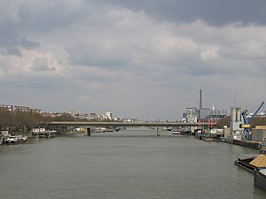
The Pont Aval (French pronunciation: [pɔ̃ aval]) is a bridge that crosses the Seine in Paris, France. It is open exclusively to motor vehicles traveling along the Boulevard Périphérique, a roadway which encircles the city.

Tennis Club de Paris
Distance: Approx. 459 meters
Latitude and longitude: 48.83472222,2.25694444
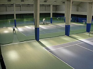
Tennis Club de Paris (Tennis Club of Paris), also known as the TCP, is a tennis club founded in 1895 in Paris.
Issy–Val de Seine station
French train station
Distance: Approx. 463 meters
Latitude and longitude: 48.82972222,2.26305556
Issy–Val de Seine is a station on RER C served by RER C5 and C7. Situated in Issy-les-Moulineaux, in the department of Hauts-de-Seine, the station serves the business district of Val de Seine. In rush hours, the station is served by 12 trains per hour; in off-peak hours, it is served by 6 trains per hour.
Sainte-Jeanne-de-Chantal, Paris
Church in Paris , France
Distance: Approx. 906 meters
Latitude and longitude: 48.838722,2.256139
Sainte-Jeanne-de-Chantal (French pronunciation: [sɛ̃t.ʒan.də.ʃɑ̃.tal]) is a Catholic church in Paris built of concrete in Byzantine style with a large dome. It was constructed between 1932 and 1956.

TF1 Tower
Tower in Boulogne-Billancourt, France
Distance: Approx. 455 meters
Latitude and longitude: 48.833889,2.260556
The TF1 Tower (French: Tour TF1) is a building in the Boulogne-Billancourt suburb of Paris, used as the headquarters of the French TV channel TF1 and several subsidiaries of the TF1 Group since 1992.

Tour Sequana
Commercial offices in Issy-les-Moulineaux, France
Distance: Approx. 936 meters
Latitude and longitude: 48.8334245,2.2689104
Tour Sequana (previously known as Tour Mozart) is an office skyscraper in Issy-les-Moulineaux, Val de Seine business district, close to Paris. 100 meters high, it can accommodate 2,720 people. It was designed by Arquitectonica in collaboration with the design office Arup Sustainable Design, and inaugurated on September 14, 2010.
Weather in this IP's area
overcast clouds
8 Celsius
8 Celsius
7 Celsius
10 Celsius
1022 hPa
71 %
1022 hPa
1018 hPa
10000 meters
1.03 m/s
100 %
08:02:02
17:09:50


