185.183.187.229 - IP Lookup: Free IP Address Lookup, Postal Code Lookup, IP Location Lookup, IP ASN, Public IP
Country:
Region:
City:
Location:
Time Zone:
Postal Code:
ISP:
ASN:
language:
User-Agent:
Proxy IP:
Blacklist:
IP information under different IP Channel
ip-api
Country
Region
City
ASN
Time Zone
ISP
Blacklist
Proxy
Latitude
Longitude
Postal
Route
db-ip
Country
Region
City
ASN
Time Zone
ISP
Blacklist
Proxy
Latitude
Longitude
Postal
Route
IPinfo
Country
Region
City
ASN
Time Zone
ISP
Blacklist
Proxy
Latitude
Longitude
Postal
Route
IP2Location
185.183.187.229Country
Region
kentriki makedonia
City
kalamaria
Time Zone
Europe/Athens
ISP
Language
User-Agent
Latitude
Longitude
Postal
ipdata
Country
Region
City
ASN
Time Zone
ISP
Blacklist
Proxy
Latitude
Longitude
Postal
Route
Popular places and events near this IP address

Kalamaria
Suburbs of the Thessaloniki Urban Area, Greece
Distance: Approx. 96 meters
Latitude and longitude: 40.58333333,22.95
Kalamariá (Greek: Καλαμαριά, Port Side) is among the most densely populated suburbs in Thessaloniki, located about 7 kilometres (4 miles) southeast of the downtown area, with a population of 92,248.

Mikro Emvolo
Distance: Approx. 873 meters
Latitude and longitude: 40.583,22.94
Mikro Emvolo (Greek: Μικρό Έμβολο), also called Karabournaki (Καραμπουρνάκι), is the cape of Kalamaria in northeastern Thessaloniki and a district of the local municipality. Its name comes from kara burun in Turkish, meaning 'black peninsula'. + Greek -aki (diminutive).

Kalamaria Stadium
Multi-purpose stadium in Kalamaria, Thessaloniki, Greece
Distance: Approx. 453 meters
Latitude and longitude: 40.581475,22.94511389
Kalamaria Stadium is a multi-purpose stadium in Kalamaria, a district of Thessaloniki, in Greece. It is currently used mostly for football matches and is the home stadium of Apollon Kalamarias. The stadium was built in 1973; renovations were made in 2003, prior to the 2004 Summer Olympics, as the stadium was used as one of the official training venues for the Olympics' football competition.

Nea Aretsou
Distance: Approx. 835 meters
Latitude and longitude: 40.575,22.95
Nea Aretsou (Greek: Νέα Αρετσού) is a district of Kalamaria, Thessaloniki, Greece. It was created in the 1920s and populated by Greek refugees from the town of Aretsou (modern Darıca) in Turkey.

Palataki (Thessaloniki)
Building in Kalamaria , Greece
Distance: Approx. 1180 meters
Latitude and longitude: 40.5835,22.9364
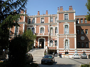
The Palataki (Παλατάκι, "little palace") is the popular name for a large neoclassical mansion in the Karabournaki area of the municipality of Kalamaria. Officially it is known as the Government House (Κυβερνείο).

Mikra British Cemetery
Distance: Approx. 1316 meters
Latitude and longitude: 40.5784,22.9649
The Mikra British Cemetery is a World War I-era British military cemetery in Kalamaria, a suburb of the city of Thessaloniki in Greece. It was opened in April 1917, and used until 1920. Following the Armistice the cemetery was greatly enlarged when remains were transferred there from other local burial grounds.

Villa Allatini
Building in Thessaloniki, Greece
Distance: Approx. 1244 meters
Latitude and longitude: 40.5929,22.9557
Villa Allatini (Greek: Βίλλα Αλλατίνι) is a three-storey baroque building on Vasilissis Olgas Avenue in the area of Depot in the east of the Municipality of Thessaloniki, Greece. It was constructed in 1898 when Thessaloniki was part of the Ottoman Empire.
Northern Greece Naval Command
Military unit
Distance: Approx. 1063 meters
Latitude and longitude: 40.5858,22.9385
Northern Greece Naval Command (Greek: Ναυτική Διοίκηση Βορείου Ελλάδος, ΝΔΒΕ), formerly the Northern Aegean Naval Command (Ναυτική Διοίκηση Βορείου Αιγαίου, ΝΔΒΑ), is a regional command of the Hellenic Navy covering the coasts of northern Greece and the northern Aegean Sea, from the Greco-Turkish border at the mouth of the river Evros to Mount Pelion.
Nomarchia metro station
Distance: Approx. 1138 meters
Latitude and longitude: 40.59138889,22.95694444
Nomarchia (Greek: Νομαρχία, , lit. 'Prefectural Administration') is an under-construction metro station serving Thessaloniki Metro's Line 2. The station is named after the nearby Villa Allatini, which housed the administrative headquarters of the Prefecture of Thessaloniki (Greek: Νομαρχία Θεσσαλονίκης, Nomarchia Thessalonikis). Prefectures were abolished in 2010, and the Villa is now the seat of the Central Macedonia region, but the station name remains unaffected.
Kalamaria metro station
Distance: Approx. 340 meters
Latitude and longitude: 40.58472222,22.95305556
Kalamaria (Greek: Καλαμαριά, ) is an under-construction metro station serving Thessaloniki Metro's Line 2. It is expected to enter service in 2025. The station gets its name from the area of Thessaloniki it serves, Kalamaria.
Aretsou metro station
Distance: Approx. 557 meters
Latitude and longitude: 40.57861111,22.95444444
Aretsou (Greek: Αρετσού, ) is an under-construction metro station serving Thessaloniki Metro's Line 2. The station gets its name from the neighbourhood it is in, Nea Aretsou, which in turn is named after the ancient Greek colony of Arethousa, modern-day Darıca. It is expected to enter service in 2025.
Nea Krini metro station
Distance: Approx. 1440 meters
Latitude and longitude: 40.5725,22.96111111
Nea Krini (Greek: Νέα Κρήνη, , lit. 'New Fountain') is an under-construction metro station serving Thessaloniki Metro's Line 2. It is expected to enter service in 2025.
Weather in this IP's area
clear sky
15 Celsius
14 Celsius
14 Celsius
17 Celsius
1021 hPa
66 %
1021 hPa
1005 hPa
10000 meters
9.39 m/s
13.41 m/s
236 degree
2 %