Country:
Region:
City:
Latitude and Longitude:
Time Zone:
Postal Code:
IP information under different IP Channel
ip-api
Country
Region
City
ASN
Time Zone
ISP
Blacklist
Proxy
Latitude
Longitude
Postal
Route
Luminati
Country
Region
ha
City
hahotrim
ASN
Time Zone
Asia/Jerusalem
ISP
ITC NG ltd
Latitude
Longitude
Postal
IPinfo
Country
Region
City
ASN
Time Zone
ISP
Blacklist
Proxy
Latitude
Longitude
Postal
Route
db-ip
Country
Region
City
ASN
Time Zone
ISP
Blacklist
Proxy
Latitude
Longitude
Postal
Route
ipdata
Country
Region
City
ASN
Time Zone
ISP
Blacklist
Proxy
Latitude
Longitude
Postal
Route
Popular places and events near this IP address
Atlit Yam
Human settlement in Israel
Distance: Approx. 4509 meters
Latitude and longitude: 32.71082778,34.93515
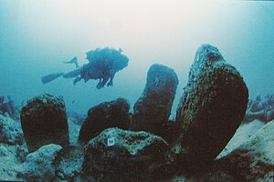
Atlit Yam is a submerged ancient Neolithic village off the coast of Atlit, Israel. It has been carbon-dated as to be between 8,900 and 8,300 years old. Among the features of the 4.0 ha (10-acre) site is a stone circle.

Atlit detainee camp
Concentration camp in Mandatory Palestine
Distance: Approx. 4229 meters
Latitude and longitude: 32.712543,34.949141
The Atlit detainee camp was a concentration camp established by the authorities of Mandatory Palestine in the late 1930s on what is now the Israeli coastal plain, 20 kilometres (12 mi) south of Haifa. Under British rule, it was primarily used to hold Jews and Arabs who were in administrative detention; it largely held Jewish immigrants who did not possess official entry permits. Tens of thousands of Jewish refugees were interned at the camp, which was surrounded by barbed wire and watchtowers.
Tirat Carmel
City in Israel
Distance: Approx. 2691 meters
Latitude and longitude: 32.76666667,34.96666667
Tirat Carmel (Hebrew: טִירַת כַּרְמֶל), or Tirat HaCarmel, is a city in the Haifa District in Israel. In 2022, it had a population of 28,753. Throughout the ages, the site of the modern city was controlled by many people, including the Romans, the Ottoman, and the British.
Sammy Ofer Stadium
Football stadium in Haifa, Israel
Distance: Approx. 4085 meters
Latitude and longitude: 32.78311111,34.96516667
Sammy Ofer Stadium (Hebrew: אצטדיון סמי עופר), also known as Haifa Municipal Stadium (האצטדיון העירוני חיפה), is a 30,942 seats multi-purpose stadium in Haifa, Israel. Construction began in late 2009 and was completed in 2014. The stadium was developed and built by the Haifa Economic Corporation, managed by Adv.
Megadim
Place in Haifa, Israel
Distance: Approx. 2692 meters
Latitude and longitude: 32.72916667,34.95916667
Megadim (Hebrew: מְגָדִים, lit. Precious) is a moshav in northern Israel. Located on the Mediterranean coast near Atlit and Highway 4, about 12 kilometres south of Haifa, it falls under the jurisdiction of Hof HaCarmel Regional Council.

Al-Tira, Haifa
Place in Haifa, Mandatory Palestine
Distance: Approx. 3078 meters
Latitude and longitude: 32.76194444,34.97527778
See Tira for other sites with similar names. al-Tira (Arabic: الطيرة, also called Tirat al-Lawz ("Tira of the almonds") or Tirat Haifa to distinguish it from other al-Tiras) was a Palestinian town located 7 kilometres south of Haifa. It was made up of five khirbets, including Khirbat al-Dayr where lie the ruins of St.

HaHotrim
Place in Haifa, Israel
Distance: Approx. 1009 meters
Latitude and longitude: 32.75138889,34.95611111
HaHotrim (Hebrew: הַחוֹתְרִים, lit. 'The Rowers') is a kibbutz in northern Israel. Located near Tirat Carmel, it falls under the jurisdiction of Hof HaCarmel Regional Council. In 2022 it had a population of 903.
Kfar Galim
Place in Haifa, Israel
Distance: Approx. 2188 meters
Latitude and longitude: 32.76611111,34.95944444
Kfar Galim (Hebrew: כְּפַר גַּלִּים, lit. 'Waves Village') is a boarding school and youth village in northern Israel. Located near Tirat Carmel, it falls under the jurisdiction of Hof HaCarmel Regional Council. In 2022 it had a population of 402.

Kfar Tzvi Sitrin
Place in Haifa, Israel
Distance: Approx. 4128 meters
Latitude and longitude: 32.71916667,34.96916667
Kfar Tzvi Sitrin (Hebrew: כפר צבי סיטרין, lit. 'Zvi Sitrin Village'), also known as Beit Tzvi (Hebrew: בֵּית צְבִי, lit. Zvi House) is a technical college and village in northern Israel. Located near Highway 4, it falls under the jurisdiction of Hof HaCarmel Regional Council.

Matam, Haifa
High-tech park in Israel
Distance: Approx. 4445 meters
Latitude and longitude: 32.78861111,34.95916667
Matam (Hebrew מת"ם - מרכז תעשיות מדע Merkaz Ta'asiyot Mada lit. acronym of Scientific Industries Center), located at the southern entrance to Haifa, is the largest and oldest dedicated hi-tech park in Israel. The Park is an international technology center, with some of the world's leading hi-tech companies maintaining research and development facilities, including Amazon, Intel, Microsoft, Yahoo!, Philips, Google, Qualcomm, CSR, NDS Group, Elbit Systems, Apple, Plus500, Matrix, Aladdin Knowledge Systems, NetManage, ProcessGene, and Neustar.
Nahal Oren (archaeological site)
Archaeological site in Israel
Distance: Approx. 4251 meters
Latitude and longitude: 32.71666667,34.96666667
Nahal Oren is an archaeological site on the northern bank of the wadi of Nahal Oren (Hebrew)/Wadi Fallah (Arabic) on Mount Carmel, 10 km (6.2 mi) south of Haifa, Israel. The site comprises a cave and the small terrace in front of it, which steeply descends towards the wadi floor. The site was first excavated in 1941.

Misliya Cave
Prehistoric cave in Mount Carmel, Israel
Distance: Approx. 2723 meters
Latitude and longitude: 32.7413,34.9724
Misliya Cave (Hebrew: מערת מיסליה), also known as the "Brotzen Cave" after Fritz Brotzen, who first described it in 1927, is a collapsed cave at Mount Carmel, Israel, containing archaeological layers from the Lower Paleolithic and Middle Paleolithic periods. The site is significant in paleoanthropology for the discovery of what were from 2018 to 2019 considered to be the earliest known remains attributed to Homo sapiens outside Africa, dated to 185,000 years ago. Since the time of its discovery in 2011, Jebel Faya, in the United Arab Emirates, had been considered to be the oldest settlement of anatomically-modern humans outside Africa, with its deepest assemblage being dated to 125,000 years ago.
Weather in this IP's area
clear sky
27 Celsius
27 Celsius
26 Celsius
27 Celsius
1017 hPa
44 %
1017 hPa
1017 hPa
10000 meters
5.66 m/s
90 degree
06:04:13
16:43:48


