Country:
Region:
City:
Latitude and Longitude:
Time Zone:
Postal Code:
IP information under different IP Channel
ip-api
Country
Region
City
ASN
Time Zone
ISP
Blacklist
Proxy
Latitude
Longitude
Postal
Route
IPinfo
Country
Region
City
ASN
Time Zone
ISP
Blacklist
Proxy
Latitude
Longitude
Postal
Route
MaxMind
Country
Region
City
ASN
Time Zone
ISP
Blacklist
Proxy
Latitude
Longitude
Postal
Route
Luminati
Country
Region
hdf
City
lille
ASN
Time Zone
Europe/Paris
ISP
Eurofiber France SAS
Latitude
Longitude
Postal
db-ip
Country
Region
City
ASN
Time Zone
ISP
Blacklist
Proxy
Latitude
Longitude
Postal
Route
ipdata
Country
Region
City
ASN
Time Zone
ISP
Blacklist
Proxy
Latitude
Longitude
Postal
Route
Popular places and events near this IP address
Roubaix
Commune in Hauts-de-France, France
Distance: Approx. 853 meters
Latitude and longitude: 50.6901,3.18167
Roubaix (US: roo-BAY, French: [ʁubɛ] or [ʁube] ; Dutch: Robaais; West Flemish: Roboais; Picard: Roubés) is a city in northern France, located in the Lille metropolitan area on the Belgian border. It is a historically mono-industrial commune in the Nord department, which grew rapidly in the 19th century from its textile industries, with most of the same characteristic features as those of English and American boom towns. This former new town has faced many challenges linked to deindustrialisation such as urban decay, with their related economic and social implications, since its major industries fell into decline by the middle of the 1970s.

La Piscine Museum
Museum in Roubaix, France
Distance: Approx. 911 meters
Latitude and longitude: 50.692577,3.16756
La Piscine (French for "the swimming pool") is a museum of art and industry, located in the city of Roubaix in northern France. It is more formally known as La Piscine-Musée d'Art et d'Industrie André Diligent or Le musée d'Art et d'Industrie de la ville de Roubaix, but its common name derives from the fact that it is housed in a former indoor swimming pool, with a notable art deco interior.
ENSAIT
Distance: Approx. 775 meters
Latitude and longitude: 50.69444444,3.16805556
The École nationale supérieure des arts et industries textiles (ENSAIT) is a French Engineering grand établissement (grande école) and a member of UP-TEX research cluster (Union Pôle Textile). ENSAIT is a higher education and research institute, gathering all the disciplines related to textiles. ENSAIT chairs include four departments related to education and research.

Roubaix station
Distance: Approx. 1068 meters
Latitude and longitude: 50.69583333,3.16305556
Roubaix station (French: Gare de Roubaix) is a railway station serving the town Roubaix, Nord department, northern France.

Tourcoing station
Distance: Approx. 2256 meters
Latitude and longitude: 50.71666667,3.16805556
Tourcoing station (French: Gare de Tourcoing) is a railway station serving the town Tourcoing, Nord department, northern France.
Verlaine Message Museum
Museum in Tourcoing, France
Distance: Approx. 2278 meters
Latitude and longitude: 50.711891,3.1551877
The Verlaine Message Museum or Museum of 5 June 1944 is a historical museum founded in 1991 in Tourcoing, France, near Lille. It is named after the message sent by the BBC's Radio Londres at 9:15 pm on June 5, 1944 announcing the imminent invasion of Normandy. The museum is housed in the concrete bunker where the German Wehrmacht intercepted the message.

Eurometropolis Lille–Kortrijk–Tournai
Transborder agglomeration in Western Europe
Distance: Approx. 1578 meters
Latitude and longitude: 50.7,3.2
Eurometropolis Lille–Kortrijk–Tournai is a metropolitan area in Europe around the transborder agglomeration of the French city of Lille, and the Belgian cities Kortrijk and Tournai. It covers the local regions Lille Métropole, south-eastern West Flanders (4 districts) and Wallonie Picarde (3 districts), 147 municipalities in total. The 2008 population was 2,155,161.
Canton of Roubaix-1
Distance: Approx. 836 meters
Latitude and longitude: 50.69,3.18
The canton of Roubaix-1 is an administrative division of the Nord department, northern France. It was created at the French canton reorganisation which came into effect in March 2015. Its seat is in Roubaix.
Hôtel Prouvost
Hôtel particulier in Roubaix, France
Distance: Approx. 1087 meters
Latitude and longitude: 50.69129,3.16597
The Hôtel Prouvost is a historic hôtel particulier in Roubaix, France. It was built in 1878 for Charles Prouvost-Scrépel. It has been listed as an official historical monument since 1998.
Hôtel Auguste-Lepoutre
Hôtel particulier in Roubaix, France
Distance: Approx. 429 meters
Latitude and longitude: 50.69365,3.17661
The Hôtel Auguste-Lepoutre is a historic hôtel particulier in Roubaix, Nord, France. It was built in 1880 for Amédée Prouvost-Yon. It was rented by Auguste Lepoutre from 1902 onwards, and it was turned into a police station in 1940.

Palais Vaissier
Former mansion in Tourcoing, France
Distance: Approx. 2392 meters
Latitude and longitude: 50.69583333,3.14416667
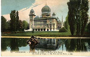
The Palais Vaissier (also called the Château Vassier or Palais du Congo) was a large Orientalist mansion in Tourcoing, Nord, (France), which served as the distinctive home of industrialist Victor Vaissier. It was designed by French architect Édouard Dupire-Rozan and built in 1891–92, but was demolished in 1929. Two of its outbuildings, the residences of its concierge and the gardener, have been preserved, however, and can be viewed today from the street.
Canton of Roubaix-Est
Former canton of France
Distance: Approx. 1064 meters
Latitude and longitude: 50.700833,3.192083
The Canton of Roubaix-Est is a former French canton, located in the Nord department in the former region of Nord-Pas-de-Calais (now part of Hauts-de-France).
Weather in this IP's area
mist
15 Celsius
15 Celsius
14 Celsius
16 Celsius
1023 hPa
86 %
1023 hPa
1019 hPa
5000 meters
4.63 m/s
30 degree
28 %
07:29:21
19:52:44
