Country:
 France
Region:
City:
Latitude and Longitude:
Time Zone:
Postal Code:
IP information under different IP Channel
ip-api
Country
Region
City
ASN
Time Zone
ISP
Blacklist
Proxy
Latitude
Longitude
Postal
Route
IPinfo
Country
Region
City
ASN
Time Zone
ISP
Blacklist
Proxy
Latitude
Longitude
Postal
Route
MaxMind
Country
Region
City
ASN
Time Zone
ISP
Blacklist
Proxy
Latitude
Longitude
Postal
Route
Luminati
Country
FRRegion
naq
City
larochelle
ASN
Time Zone
Europe/Paris
ISP
Groupe Telecoms De L Ouest SAS
Latitude
Longitude
Postal
db-ip
Country
Region
City
ASN
Time Zone
ISP
Blacklist
Proxy
Latitude
Longitude
Postal
Route
ipdata
Country
Region
City
ASN
Time Zone
ISP
Blacklist
Proxy
Latitude
Longitude
Postal
Route
Popular places and events near this IP address

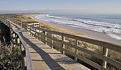
Île de Ré
Island off the coast of France
Distance: Approx. 3673 meters
Latitude and longitude: 46.2,-1.41666667
Île de Ré (French pronunciation: [il də ʁe]; variously spelled Rhé or Rhéa; Poitevin: ile de Rét; English: Isle of Ré, RAY) is an island off the Atlantic coast of France near La Rochelle, Charente-Maritime, on the northern side of the Pertuis d'Antioche strait. Its highest point has an elevation of 20 metres (66 feet). It is 30 kilometres (19 miles) long and five kilometres (3 miles) wide.

Saint-Martin-de-Ré
Commune in Nouvelle-Aquitaine, France
Distance: Approx. 5965 meters
Latitude and longitude: 46.2031,-1.3672
Saint-Martin-de-Ré (French pronunciation: [sɛ̃ maʁtɛ̃ də ʁe], lit. "St Martin of Ré"; Saintongeais: Sént-Martin-de-Ré, before 1962: Saint-Martin) is a commune in the western French department of Charente-Maritime. It is one of the ten communes located on the Île de Ré.
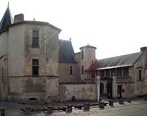
Ernest Cognacq Museum
Art and history collections, Île de Ré, France
Distance: Approx. 5972 meters
Latitude and longitude: 46.20527778,-1.36527778
The Ernest Cognacq Museum (French: Musée Ernest Cognacq) is a French regional history museum, located in the city of Saint Martin de Ré, Île de Ré, France. The museum is housed in the "Hotel de Clerjotte", built in 1470-1480 by Louis Clergeat, taxman for Charles de France, Duke of Guyenne, and master of Île de Ré. Clergeat seems to have given his name to the building (the "House of Clergeatte") to become "Hotel de Clerjotte" today.
Le Bois-Plage-en-Ré
Commune in Nouvelle-Aquitaine, France
Distance: Approx. 5821 meters
Latitude and longitude: 46.1872,-1.3919
Le Bois-Plage-en-Ré (French pronunciation: [lə bwa plaʒ ɑ̃ ʁe]) is a commune in the Charente-Maritime department in the Nouvelle-Aquitaine region in southwestern France. It is situated on the Île de Ré.

La Couarde-sur-Mer
Commune in Nouvelle-Aquitaine, France
Distance: Approx. 3993 meters
Latitude and longitude: 46.1956,-1.4242
La Couarde-sur-Mer (French pronunciation: [la kwaʁd syʁ mɛʁ], literally La Couarde on Sea) is a commune in the Charente-Maritime department, Nouvelle-Aquitaine, southwestern France. It is situated on the Île de Ré.

Loix
Commune in Nouvelle-Aquitaine, France
Distance: Approx. 1033 meters
Latitude and longitude: 46.2233,-1.4411
Loix (French pronunciation: [lwa]) is a commune in the south-west of France, located on the north coast of the Île de Ré, in the department of Charente-Maritime (region Nouvelle-Aquitaine).

Les Portes-en-Ré
Commune in Nouvelle-Aquitaine, France
Distance: Approx. 5388 meters
Latitude and longitude: 46.2508,-1.4972
Les Portes-en-Ré (French pronunciation: [le pɔʁt(z)‿ɑ̃ ʁe]) is a commune of southwestern France, located on the Ré Island, in the French department of Charente-Maritime, historical region of Poitou-Charentes, administrative region of Nouvelle-Aquitaine.
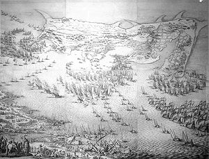
Siege of Saint-Martin-de-Ré
Battle
Distance: Approx. 5965 meters
Latitude and longitude: 46.2031,-1.3672
The siege of Saint-Martin-de-Ré, or siege of St. Martin's (French: siège de Saint-Martin-de-Ré), was an attempt by English forces under George Villiers, the Duke of Buckingham, to capture the French fortress-city of Saint-Martin-de-Ré, on the isle of Ré (near La Rochelle), in 1627. After three months of siege, the Marquis de Toiras and a relief force of French ships and troops managed to repel the Duke, who was forced to withdraw in defeat.

Recovery of Ré island
1625 military conflict
Distance: Approx. 4295 meters
Latitude and longitude: 46.2,-1.4
The Recovery of Ré Island (French: Reprise de l'Île de Ré) was accomplished by the army of Louis XIII in September 1625, against the troops of the Protestant admiral Soubise and the Huguenot forces of La Rochelle, who had been occupying the Island of Ré since February 1625 as part of the Huguenot rebellions.

Naval battle of Saint-Martin-de-Ré
1622 naval battle
Distance: Approx. 5484 meters
Latitude and longitude: 46.215,-1.366
The Naval battle of Saint-Martin-de-Ré (French:Bataille navale de Saint-Martin-de-Ré) took place on 27 October 1622, between the Huguenot fleet of La Rochelle under Jean Guiton, and a Royal fleet under Charles de Guise. Under Henry IV the city had enjoyed a certain freedom and prosperity until the 1620s, but the city entered in conflict with the central authority of King Louis XIII with the Huguenot rebellion of 1622. Louis XIII sent a small army for a Blockade of La Rochelle in 1621 and 1622.
Saint Catherine Church of Loix
19th century church in France
Distance: Approx. 809 meters
Latitude and longitude: 46.2244,-1.4381
The Church of Saint Catherine is a parish church located in Loix, in the department of Charente-Maritime, the region of Nouvelle-Aquitaine and the diocese of La Rochelle and Saintes.

Battle of Pont du Feneau
Last battle, failed English withdrawal
Distance: Approx. 2272 meters
Latitude and longitude: 46.217,-1.455
The Battle of Pont du Feneau was the last battle of the siege of Saint-Martin-de-Ré by the English forces that had come to help the Huguenot rebellions of La Rochelle. It took place on 8 November 1627. The English lost the battle, and this final failure forced them to withdraw back to England.
Weather in this IP's area
clear sky
16 Celsius
16 Celsius
16 Celsius
16 Celsius
1019 hPa
77 %
1019 hPa
1018 hPa
10000 meters
2.57 m/s
310 degree
08:27:09
19:14:10