Country:
 Sweden
Region:
City:
Latitude and Longitude:
Time Zone:
Postal Code:
IP information under different IP Channel
ip-api
Country
Region
City
ASN
Time Zone
ISP
Blacklist
Proxy
Latitude
Longitude
Postal
Route
IPinfo
Country
Region
City
ASN
Time Zone
ISP
Blacklist
Proxy
Latitude
Longitude
Postal
Route
MaxMind
Country
Region
City
ASN
Time Zone
ISP
Blacklist
Proxy
Latitude
Longitude
Postal
Route
Luminati
Country
SEASN
Time Zone
Europe/Stockholm
ISP
GlobalConnect AB
Latitude
Longitude
Postal
db-ip
Country
Region
City
ASN
Time Zone
ISP
Blacklist
Proxy
Latitude
Longitude
Postal
Route
ipdata
Country
Region
City
ASN
Time Zone
ISP
Blacklist
Proxy
Latitude
Longitude
Postal
Route
Popular places and events near this IP address
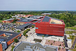
Linköping University
Public university in Linköping, Sweden
Distance: Approx. 822 meters
Latitude and longitude: 58.39916667,15.57694444
Linköping University (LiU; Swedish: Linköpings universitet) is a public research university based in Linköping, Sweden. Originally established in 1969, it was granted full university status in 1975 and is one of Sweden's largest academic institutions. The university has four campuses across three cities: Campus Valla and Campus US in Linköping, Campus Norrköping in Norrköping and Campus Lidingö in Stockholm.
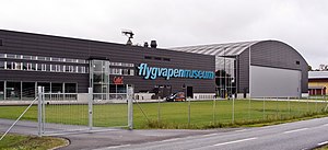
Swedish Air Force Museum
Military museum in Sweden
Distance: Approx. 2784 meters
Latitude and longitude: 58.41,15.52361111
The Swedish Air Force Museum (Swedish: Flygvapenmuseum) is located at Malmen Airbase in Malmslätt, just outside Linköping, Sweden. Malmen is where Baron Carl Cederström, nicknamed the "Flyer Baron" founded his flying school in 1912. Malmen Airbase is home to the Royal Swedish Airschool operating SAAB 105 (SK60) jet trainers.
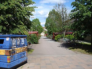
Ryd, Linköping
City district in Linköping, Sweden
Distance: Approx. 1381 meters
Latitude and longitude: 58.40888889,15.5625
Ryd is a city district in Linköping, Sweden, best known for housing the bulk of the Linköping University (Linköpings Universitet, LiU) student body. They live in houses specifically assigned to LiU's students. Many of these homes are in the form of corridor rooms, where students have their own bedroom with an en-suite bathroom but a shared kitchen.

Valla Wood
Distance: Approx. 1684 meters
Latitude and longitude: 58.403,15.58986
Valla Wood (in Swedish, Vallaskogen) is a nature reserve in the municipality of Linköping, in the county of Östergötland, Sweden. It is the forested area nearest the city centre. Because the main campus of the University of Linköping lies on the other side of it, many students and workers cycle back and forth daily on the small road through it.

Linköping Science Park
City district in Östergötland, Linköping, Sweden
Distance: Approx. 331 meters
Latitude and longitude: 58.39416667,15.56027778
Linköping Science Park (formerly Mjärdevi Science Park & Science Park Mjärdevi) is a city district and technology area in Östergötland in the city of Linköping. The area Mjärdevi is located just outside Linköping University Campus Valla and is the core area for Linköping Science park, although the science park operates throughout Linköping and the surrounding region. Linköping Science park includes about 600 companies with a total of 14 000 employees (2023).
Djurgården, Linköping
Swedish city district
Distance: Approx. 2400 meters
Latitude and longitude: 58.39175,15.60393333
Djurgården is a city district between Garnisonen and Lambohov in Linköping, which is the process of being developed. It is meant to contain 3 000-5 000 housing units, 200,000 to 300,000 square metres of office space and 30,000 square metres of commerce. Construction start for Djurgårdens centre, the first area in the district, is estimated to be in 2011.

Gottfridsberg
Distance: Approx. 2653 meters
Latitude and longitude: 58.4127,15.59716667
Gottfridsberg in Linköping is a city district, west of the Inner City. It consists of the areas Barhäll, Fridhem, old Gottfridsberg, Tornhagen and Åbylund. The area bounded on the south by Malmslättsvägen, to the east by Västra vägen and Bergsvägen, in the north by the railroad and to the west by Rydsskogen.

Jägarvallen
Distance: Approx. 1326 meters
Latitude and longitude: 58.3972,15.5411
Jägarvallen is a city district in Linköping with a little over 140 households and almost 400 residents. It is located on the outskirts of the city, between Ryd and Malmen airfield, and is crossed by an old stretch of the road to Mjölby. The eastern part of Jägarvallen is dominated by an industrial area, while the western end, closest Malmen airfield, has apartment buildings.

Lambohov
Distance: Approx. 1714 meters
Latitude and longitude: 58.38166667,15.57166667
Lambohov () is a Swedish city district in southwestern Linköping. It is also the name of the manor around which the district has evolved. The district grew in the 1980s and over 50% of the buildings were erected from 1981 to 1990.

Västra Valla
Distance: Approx. 715 meters
Latitude and longitude: 58.39388889,15.575
Västra Valla is a city district in western Linköping. Västra Valla includes the campus of Linköping University. Districts adjoining Västra Valla are East Valla, Gottfridsberg, Garnisonen, Lambohov, Mjärdevi, Djurgården and Ryd.

Östra Valla
City district in Linköping, Sweden
Distance: Approx. 1879 meters
Latitude and longitude: 58.40416667,15.5925
Östra Valla is a city district in western Linköping. It includes Griftegård, the Valla wood, and a business park. Östra Valla adjoins the districts West Valla, Gottfridsberg, Downtown, Djurgården, Ekkällan and Garnisonen.
Linköping Golf Club
Golf club in Linköping, Sweden
Distance: Approx. 665 meters
Latitude and longitude: 58.40155,15.5699
Linköping Golf Club is a golf club located 3 km west of central Linköping in Östergötland County, Sweden. It has hosted the Scandinavian Enterprise Open on the European Tour.
Weather in this IP's area
broken clouds
26 Celsius
26 Celsius
25 Celsius
27 Celsius
1014 hPa
53 %
1014 hPa
1006 hPa
10000 meters
6.69 m/s
140 degree
77 %
06:12:44
19:38:19