Country:
Region:
City:
Latitude and Longitude:
Time Zone:
Postal Code:
IP information under different IP Channel
ip-api
Country
Region
City
ASN
Time Zone
ISP
Blacklist
Proxy
Latitude
Longitude
Postal
Route
Luminati
Country
Region
140
City
vrhnika
ASN
Time Zone
Europe/Ljubljana
ISP
T-2, d.o.o.
Latitude
Longitude
Postal
IPinfo
Country
Region
City
ASN
Time Zone
ISP
Blacklist
Proxy
Latitude
Longitude
Postal
Route
db-ip
Country
Region
City
ASN
Time Zone
ISP
Blacklist
Proxy
Latitude
Longitude
Postal
Route
ipdata
Country
Region
City
ASN
Time Zone
ISP
Blacklist
Proxy
Latitude
Longitude
Postal
Route
Popular places and events near this IP address

Vrhnika
Town in Inner Carniola, Slovenia
Distance: Approx. 579 meters
Latitude and longitude: 45.962375,14.29373611
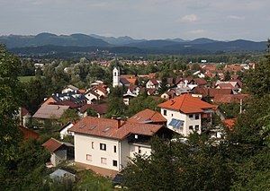
Vrhnika (pronounced [ˈʋəɾxnika] ; German: Oberlaibach; Latin: Nauportus) is a town in Slovenia. It is the seat of the Municipality of Vrhnika. It is located on the Ljubljanica River, 21 km from Ljubljana along the A1 motorway.
Nauportus
Distance: Approx. 643 meters
Latitude and longitude: 45.96966111,14.30303056
Nauportus (Navport, Navportus) (Ancient Greek: Ναύπορτον), was an ancient Roman town in Pannonia Superior (later 10th Italian region) on the road from Aquileia to Emona with a port at the Nauportus river, now the Ljubljanica River, Slovenia. Strabo wrote that near the Nauportus was a river, called Corcoras (Ancient Greek: Κορκόρας), which received the cargoes. According to historian Pliny the Elder, the name was derived from the legendary landing of the Argonauts at the river, where they are said to have founded the town.
Bistra, Vrhnika
Place in Inner Carniola, Slovenia
Distance: Approx. 3102 meters
Latitude and longitude: 45.94704167,14.33249722
Bistra (pronounced [ˈbiːstɾa]; German: Freudenthal) is a small settlement in the Municipality of Vrhnika in the Inner Carniola region of Slovenia.
Mirke
Place in Inner Carniola, Slovenia
Distance: Approx. 893 meters
Latitude and longitude: 45.95672222,14.29625833
Mirke (pronounced [ˈmiːɾkɛ]) is a small settlement immediately south of Vrhnika in the Inner Carniola region of Slovenia.

Verd
Place in Inner Carniola, Slovenia
Distance: Approx. 1221 meters
Latitude and longitude: 45.95314444,14.30004444
Verd (pronounced [ˈʋɛɾt]; in older sources also Vrd, German: Werd) is a settlement south of Vrhnika in the Inner Carniola region of Slovenia. The Verd Viaduct on the A1 motorway from Ljubljana to Koper runs above the settlement.

Strmica, Vrhnika
Place in Inner Carniola, Slovenia
Distance: Approx. 2734 meters
Latitude and longitude: 45.95178333,14.27023889
Strmica (pronounced [ˈstəɾmitsa]) is a small settlement in the hills west of Vrhnika in the Inner Carniola region of Slovenia.

Stara Vrhnika
Place in Inner Carniola, Slovenia
Distance: Approx. 1976 meters
Latitude and longitude: 45.97443611,14.28003333
Stara Vrhnika (pronounced [ˈstaːɾa ˈʋəɾxnika]; German: Altoberlaibach) is a village north of Vrhnika in the Inner Carniola region of Slovenia. It includes the hamlets of Kuren (or Koren), Podčelo, and Razor.
Sinja Gorica
Place in Inner Carniola, Slovenia
Distance: Approx. 2403 meters
Latitude and longitude: 45.98026667,14.32138611
Sinja Gorica (pronounced [ˈsiːnja ɡɔˈɾiːtsa]; German: Schweinbüchl or Schweinsbüchel, later Scheinbüchel) is a settlement immediately northwest of Vrhnika in the Inner Carniola region of Slovenia. The settlement consists of two parts: the older part stands to the southeast, built around the foot of a hill and along the road to Blatna Brezovica. The newer part, the hamlet of Sap, stands along the main road from Vrhnika to Ljubljana.
26 October Barracks
Former Slovenian Armed Forces barracks
Distance: Approx. 1226 meters
Latitude and longitude: 45.97259167,14.29071389
Ivan Cankar Barracks are a base of the Slovenian Armed Forces, located south of Vrhnika in Vrhnika Municipality, central Slovenia. A park in front of the barracks contains two monuments to the liberation struggle during World War II and is listed as cultural heritage.

Municipality of Vrhnika
Municipality of Slovenia
Distance: Approx. 292 meters
Latitude and longitude: 45.96666667,14.3
The Municipality of Vrhnika (pronounced [ˈʋəɾxnika] ; Slovene: Občina Vrhnika) is a municipality in Slovenia. The administrative seat of the municipality is the town of Vrhnika.

Močilnik Springs
Distance: Approx. 1040 meters
Latitude and longitude: 45.956473,14.293031
Močilnik Springs is the best-known source of the Ljubljanica River.
Retovje Springs
Distance: Approx. 1500 meters
Latitude and longitude: 45.95106,14.295935
Retovje Springs is a group of springs that join to form the Big Ljubljanica River (Slovene: Velika Ljubljanica).
Weather in this IP's area
overcast clouds
5 Celsius
5 Celsius
4 Celsius
10 Celsius
1013 hPa
97 %
1013 hPa
978 hPa
10000 meters
0.21 m/s
0.52 m/s
197 degree
100 %
07:09:10
16:27:40


