185.179.166.147 - IP Lookup: Free IP Address Lookup, Postal Code Lookup, IP Location Lookup, IP ASN, Public IP
Country:
 Germany
Region:
City:
Location:
Time Zone:
Postal Code:
ISP:
ASN:
language:
User-Agent:
Proxy IP:
Blacklist:
IP information under different IP Channel
ip-api
Country
Region
City
ASN
Time Zone
ISP
Blacklist
Proxy
Latitude
Longitude
Postal
Route
db-ip
Country
Region
City
ASN
Time Zone
ISP
Blacklist
Proxy
Latitude
Longitude
Postal
Route
IPinfo
Country
Region
City
ASN
Time Zone
ISP
Blacklist
Proxy
Latitude
Longitude
Postal
Route
IP2Location
185.179.166.147Country
deRegion
rheinland-pfalz
City
rosenheim
Time Zone
Europe/Berlin
ISP
Language
User-Agent
Latitude
Longitude
Postal
ipdata
Country
Region
City
ASN
Time Zone
ISP
Blacklist
Proxy
Latitude
Longitude
Postal
Route
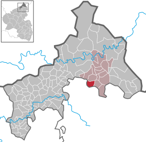
Popular places and events near this IP address

Elkenroth
Municipality in Rhineland-Palatinate, Germany
Distance: Approx. 2829 meters
Latitude and longitude: 50.72777778,7.88305556
Elkenroth is a municipality that lies on the boundary of the Westerwald region in the district of Altenkirchen, Rhineland-Palatinate, Germany. It belongs to the Verbandsgemeinde of Betzdorf-Gebhardshain.

Luckenbach
Municipality in Rhineland-Palatinate, Germany
Distance: Approx. 1383 meters
Latitude and longitude: 50.70555556,7.83472222
Luckenbach is an Ortsgemeinde – a community belonging to a Verbandsgemeinde – in the Westerwaldkreis in Rhineland-Palatinate, Germany.

Dickendorf
Municipality in Rhineland-Palatinate, Germany
Distance: Approx. 3199 meters
Latitude and longitude: 50.74111111,7.85305556
Dickendorf is a municipality in the district of Altenkirchen, in Rhineland-Palatinate, Germany. Abutting a vast forest area, it is located in the Westerwald (literally "Western Forest") which is a low mountain range on the right bank of the river Rhine. The river Elbbach flows through this town.
Kausen
Municipality in Rhineland-Palatinate, Germany
Distance: Approx. 3656 meters
Latitude and longitude: 50.74277778,7.87083333
Kausen is a municipality in the district of Altenkirchen, in Rhineland-Palatinate, in western Germany.

Nauroth
Municipality in Rhineland-Palatinate, Germany
Distance: Approx. 2202 meters
Latitude and longitude: 50.70055556,7.87611111
Nauroth is a municipality in the district of Altenkirchen, in Rhineland-Palatinate, in western Germany.

Steinebach/Sieg
Municipality in Rhineland-Palatinate, Germany
Distance: Approx. 2763 meters
Latitude and longitude: 50.73194444,7.82694444
Steinebach/Sieg is a municipality in the district of Altenkirchen, in Rhineland-Palatinate, in western Germany.

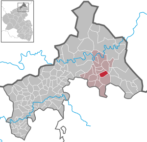
Rosenheim, Rhineland-Palatinate
Municipality in Rhineland-Palatinate, Germany
Distance: Approx. 90 meters
Latitude and longitude: 50.713064,7.850364
Rosenheim is a municipality in the district of Altenkirchen, in Rhineland-Palatinate, Germany. Not to be confused with Rosenheim in Bavaria.
Malberg, Altenkirchen
Municipality in Rhineland-Palatinate, Germany
Distance: Approx. 2152 meters
Latitude and longitude: 50.715,7.82085
Malberg is a municipality in the district of Altenkirchen, in Rhineland-Palatinate, in western Germany.

Atzelgift
Municipality in Rhineland-Palatinate, Germany
Distance: Approx. 2357 meters
Latitude and longitude: 50.69916667,7.825
Atzelgift is an Ortsgemeinde – a community belonging to a Verbandsgemeinde – in the Westerwaldkreis in Rhineland-Palatinate, Germany.

Streithausen
Municipality in Rhineland-Palatinate, Germany
Distance: Approx. 3279 meters
Latitude and longitude: 50.69361111,7.81527778
Streithausen is an Ortsgemeinde – a community belonging to a Verbandsgemeinde – and a state-recognized tourism community (Fremdenverkehrsgemeinde) in the Westerwaldkreis in Rhineland-Palatinate, Germany.
Mörlen
Municipality in Rhineland-Palatinate, Germany
Distance: Approx. 2842 meters
Latitude and longitude: 50.69805556,7.88444444
Mörlen is an Ortsgemeinde – a community belonging to a Verbandsgemeinde – in the Westerwaldkreis in Rhineland-Palatinate, Germany.

Limbach, Westerwaldkreis
Municipality in Rhineland-Palatinate, Germany
Distance: Approx. 3618 meters
Latitude and longitude: 50.7025,7.80222222
Limbach is an Ortsgemeinde – a community belonging to a Verbandsgemeinde – in the Westerwaldkreis in Rhineland-Palatinate, Germany. The agriculturally structured residential community belongs to the Verbandsgemeinde of Hachenburg, a kind of collective municipality. Its seat is in the like-named town.
Weather in this IP's area
broken clouds
-1 Celsius
-7 Celsius
-2 Celsius
-0 Celsius
1023 hPa
88 %
1023 hPa
982 hPa
9000 meters
6.17 m/s
120 degree
75 %