Country:
Region:
City:
Latitude and Longitude:
Time Zone:
Postal Code:
IP information under different IP Channel
ip-api
Country
Region
City
ASN
Time Zone
ISP
Blacklist
Proxy
Latitude
Longitude
Postal
Route
IPinfo
Country
Region
City
ASN
Time Zone
ISP
Blacklist
Proxy
Latitude
Longitude
Postal
Route
MaxMind
Country
Region
City
ASN
Time Zone
ISP
Blacklist
Proxy
Latitude
Longitude
Postal
Route
Luminati
Country
Region
ara
City
lempdes
ASN
Time Zone
Europe/Paris
ISP
Abeille Sarl
Latitude
Longitude
Postal
db-ip
Country
Region
City
ASN
Time Zone
ISP
Blacklist
Proxy
Latitude
Longitude
Postal
Route
ipdata
Country
Region
City
ASN
Time Zone
ISP
Blacklist
Proxy
Latitude
Longitude
Postal
Route
Popular places and events near this IP address

Clermont-Ferrand Auvergne Airport
Airport in Clermont-Ferrand
Distance: Approx. 3368 meters
Latitude and longitude: 45.78583333,3.1625
Clermont-Ferrand Auvergne Airport (French: Aéroport de Clermont-Ferrand Auvergne) (IATA: CFE, ICAO: LFLC) is an airport serving the French city of Clermont-Ferrand. It is located 6.7 km (3.6 nautical miles) east of the city, in Aulnat, both communes of the Puy-de-Dôme department in the Auvergne region of France, in the middle of France. It is the main airport of the Auvergne region, the others are Aurillac Airport and Le-Puy-en-Velay Airport.

Pont-du-Château
Commune in Auvergne-Rhône-Alpes, France
Distance: Approx. 4774 meters
Latitude and longitude: 45.7992,3.2492
Pont-du-Château (French: [pɔ̃ dy ʃɑto]; Auvergnat: Pont dau Chastèl; literally 'Bridge of the Castle') is a commune in the Puy-de-Dôme department in Auvergne-Rhône-Alpes in central France.
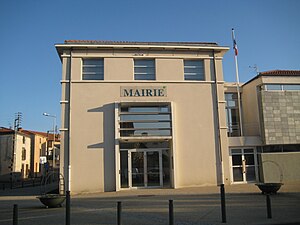
Lempdes
Commune in Auvergne-Rhône-Alpes, France
Distance: Approx. 538 meters
Latitude and longitude: 45.7719,3.1944
Lempdes (French pronunciation: [lɑ̃ːd]; Auvergnat: Lende) is a commune in the Puy-de-Dôme department in Auvergne in central France.
Aulnat
Commune in Auvergne-Rhône-Alpes, France
Distance: Approx. 4993 meters
Latitude and longitude: 45.8108,3.1683
Aulnat (French pronunciation: [o(l)na]) is a commune in the Puy-de-Dôme department in Auvergne-Rhône-Alpes in central France.

Cournon-d'Auvergne
Commune in Auvergne-Rhône-Alpes, France
Distance: Approx. 3366 meters
Latitude and longitude: 45.7422,3.1972
Cournon-d'Auvergne (French pronunciation: [kuʁnɔ̃ dovɛʁɲ]; Auvergnat: Cornon d'Auvèrnhe) is a commune in the Puy-de-Dôme department in Auvergne-Rhône-Alpes in central France. It lies 10 km (6.2 mi) southeast of Clermont-Ferrand, the prefecture and largest city of Puy-de-Dôme.

Dallet
Part of Mur-sur-Allier in Auvergne-Rhône-Alpes, France
Distance: Approx. 2960 meters
Latitude and longitude: 45.7714,3.2394
Dallet (French pronunciation: [dalɛ]) is a former commune in the Puy-de-Dôme department in Auvergne in central France. On 1 January 2019, it was merged into the new commune Mur-sur-Allier.

Malintrat
Commune in Auvergne-Rhône-Alpes, France
Distance: Approx. 4973 meters
Latitude and longitude: 45.8158,3.1867
Malintrat (French pronunciation: [malɛ̃tʁa]) is a commune in the Puy-de-Dôme département in Auvergne-Rhône-Alpes in central France. Malintrat is located at east of Clermont-Ferrand between autoroutes A710 and A720, north of the Clermont-Ferrand/Auvergne airport in Aulnat. Malintrat forms part of the Clermont-Ferrand urban area.
Mezel
Part of Mur-sur-Allier in Auvergne-Rhône-Alpes, France
Distance: Approx. 3730 meters
Latitude and longitude: 45.7558,3.2431
Mezel (Auvergnat: Meselh) is a former commune in the Puy-de-Dôme department in Auvergne in central France. On 1 January 2019, it was merged into the new commune Mur-sur-Allier.
Saint-Bonnet-lès-Allier
Commune in Auvergne-Rhône-Alpes, France
Distance: Approx. 5304 meters
Latitude and longitude: 45.742,3.254
Saint-Bonnet-lès-Allier (French pronunciation: [sɛ̃ bɔnɛ lɛ.z‿alje], literally Saint-Bonnet near Allier; Auvergnat: Sent Bonet d'Alèir) is a commune in the Puy-de-Dôme department in Auvergne-Rhône-Alpes in central France.
Canton of Cournon-d'Auvergne
Distance: Approx. 3597 meters
Latitude and longitude: 45.74,3.2
The canton of Cournon-d'Auvergne is an administrative division of the Puy-de-Dôme department, central France. Its borders were modified at the French canton reorganisation which came into effect in March 2015. Its seat is in Cournon-d'Auvergne.
Canton of Pont-du-Château
Distance: Approx. 4879 meters
Latitude and longitude: 45.8,3.25
The canton of Pont-du-Château is an administrative division of the Puy-de-Dôme department, central France. Its borders were modified at the French canton reorganisation which came into effect in March 2015. Its seat is in Pont-du-Château.

Mur-sur-Allier
Commune in Auvergne-Rhône-Alpes, France
Distance: Approx. 3730 meters
Latitude and longitude: 45.7558,3.2431
Mur-sur-Allier (French pronunciation: [myʁ syʁ alje], literally Mur on Allier) is a commune in the Puy-de-Dôme department in Auvergne in central France. It was established on 1 January 2019 by merger of the former communes of Mezel (the seat) and Dallet.
Weather in this IP's area
clear sky
12 Celsius
12 Celsius
12 Celsius
12 Celsius
1011 hPa
94 %
1011 hPa
971 hPa
10000 meters
1.54 m/s
08:07:58
18:56:16
