Country:
Region:
City:
Latitude and Longitude:
Time Zone:
Postal Code:
IP information under different IP Channel
ip-api
Country
Region
City
ASN
Time Zone
ISP
Blacklist
Proxy
Latitude
Longitude
Postal
Route
Luminati
Country
Region
dl
City
newdelhi
ASN
Time Zone
Asia/Kolkata
ISP
LLC Digital Network
Latitude
Longitude
Postal
IPinfo
Country
Region
City
ASN
Time Zone
ISP
Blacklist
Proxy
Latitude
Longitude
Postal
Route
db-ip
Country
Region
City
ASN
Time Zone
ISP
Blacklist
Proxy
Latitude
Longitude
Postal
Route
ipdata
Country
Region
City
ASN
Time Zone
ISP
Blacklist
Proxy
Latitude
Longitude
Postal
Route
Popular places and events near this IP address
National Institute of Science Communication and Information Resources
Information science institute in New Delhi, India
Distance: Approx. 1588 meters
Latitude and longitude: 28.639,77.173
The National Institute of Science Communication and Information Resources (NISCAIR), located at New Delhi, India, was an information science institute in India founded in 2002. In 2021, the institute was merged with National Institute of Science, Technology and Development Studies to form National Institute of Science Communication and Policy Research (NIScPR). It operated under the umbrella of the Council of Scientific and Industrial Research (CSIR) that comprise 38 other labs and institutes in India.
Patel Nagar
Sub-division in Delhi, India
Distance: Approx. 320 meters
Latitude and longitude: 28.6505,77.1691
Patel Nagar is one of the 3 sub-division of the West Delhi District in India.

Patel Nagar metro station
Metro station in Delhi, India
Distance: Approx. 833 meters
Latitude and longitude: 28.645,77.16930556
The Patel Nagar metro station is located on the Blue Line of the Delhi Metro. It connects to east, west, and south Patel Nagar with the rest of Delhi.

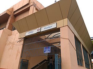
Shadipur metro station
Metro station in Delhi, India
Distance: Approx. 787 meters
Latitude and longitude: 28.651655,77.15824889
The Shadipur or Patel Nagar (West) metro station is located on the Blue Line of the Delhi Metro, situated in the Shadipur area.

Kirti Nagar metro station
Metro station in Delhi, India
Distance: Approx. 1487 meters
Latitude and longitude: 28.65511111,77.1515
The Kirti Nagar metro station is an interchange station between the Blue Line and Green Line of Delhi Metro. It is one of the eastward terminal stations of the Green Line, the other being Inderlok, and was opened as a part of a small 3.41 km (2.12 mi) branch from this station to Ashok Park Main station on 27 August 2011. This allowed passengers to easily transfer between the Red Line and Blue Line of the network.

Satguru Ram Singh Marg metro station
Metro station in Delhi, India
Distance: Approx. 1402 meters
Latitude and longitude: 28.66204781,77.15764431
The Satguru Ram Singh Marg metro station is located on the Green Line of the Delhi Metro. This section was opened on 27 August 2011 along with Kirti Nagar. Nearest Indian Railway Network Station is Patel Nagar Railway Station located adjacent to the metro station.
Patel Nagar Assembly constituency
Constituency of the Delhi legislative assembly in India
Distance: Approx. 278 meters
Latitude and longitude: 28.654,77.168
Patel Nagar is one of the seventy constituencies in the Delhi Legislative Assembly located in northern India. It is part of the New Delhi Lok Sabha constituency.

Kathputli Colony
Neighborhood of Delhi in India
Distance: Approx. 1436 meters
Latitude and longitude: 28.655,77.152
Kathputli Colony is a colony of street performers in Shadipur Depot area of Delhi. For the last 50 years, it is home to some 2,800 families of magicians, snake charmers, acrobats, singers, dancers, actors, traditional healers and musicians and especially puppeteers or kathputli-performers from Rajasthan. This makes it world’s largest community of street performers.
Patel Nagar railway station
Delhi ring railway network station
Distance: Approx. 1310 meters
Latitude and longitude: 28.6603,77.1568
Patel Nagar railway station is a railway station in Patel Nagar which is a residential and commercial neighborhood of West Delhi area of Delhi. Its code is PTNR. The station is part of Delhi Suburban Railway. The station consists of 7 platforms.
West Patel Nagar
District Subdivision in Delhi, India
Distance: Approx. 320 meters
Latitude and longitude: 28.6505,77.1691
West Patel Nagar is a place in West Delhi. It covers the Western Part of the Patel Nagar Area. In the past West Patel Nagar was counted in Central Delhi but due continues City expansion West Patel Nagar and its Sub division colonies like New Ranjit Nagar or Baljeet Nagar come under West Delhi.
East Patel Nagar
District Subdivision in Delhi, India
Distance: Approx. 320 meters
Latitude and longitude: 28.6505,77.1691
East Patel Nagar is a region of Central Delhi. It covers the eastern part of the Patel Nagar area. Among the three divisions of Municipal Corporation of Delhi, North, South and East, East Patel Nagar falls under Municipal Corporation of Delhi-North.
South Patel Nagar
District Subdivision in Delhi, India
Distance: Approx. 320 meters
Latitude and longitude: 28.6505,77.1691
South Patel Nagar is a place in Central Delhi. It covers the Southern Part of the Patel Nagar Area. In the past South Patel Nagar was counted in Central Delhi but due to the continued city expansion, South Patel Nagar and its subdivision colonies like New Ranjit Nagar now come under West Delhi.
Weather in this IP's area
haze
19 Celsius
18 Celsius
19 Celsius
19 Celsius
1015 hPa
59 %
1015 hPa
989 hPa
2100 meters
06:48:17
17:26:01