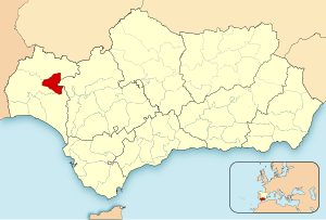
Country:
 Spain
SpainRegion:
City:
Latitude and Longitude:
Time Zone:
Postal Code:
IP information under different IP Channel
ip-api
Country
Region
City
ASN
Time Zone
ISP
Blacklist
Proxy
Latitude
Longitude
Postal
Route
IPinfo
Country
Region
City
ASN
Time Zone
ISP
Blacklist
Proxy
Latitude
Longitude
Postal
Route
MaxMind
Country
Region
City
ASN
Time Zone
ISP
Blacklist
Proxy
Latitude
Longitude
Postal
Route
Luminati
Country
ESRegion
an
City
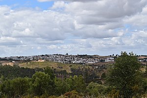
nerva
ASN
Time Zone
Europe/Madrid
ISP
Snell Cuenca Minera S.L
Latitude
Longitude
Postal
db-ip
Country
Region
City
ASN
Time Zone
ISP
Blacklist
Proxy
Latitude
Longitude
Postal
Route
ipdata
Country
Region
City
ASN
Time Zone
ISP
Blacklist
Proxy
Latitude
Longitude
Postal
Route
Popular places and events near this IP address

Berrocal
Place in Andalusia, Spain
Distance: Approx. 9820 meters
Latitude and longitude: 37.60888889,-6.5425
Berrocal is a city located in the province of Huelva, Spain. According to the 2005 census, the city has a population of 371 inhabitants.
El Campillo, Huelva
Municipality in Andalusia, Spain
Distance: Approx. 6283 meters
Latitude and longitude: 37.683,-6.617
El Campillo, or Campillo, is a municipality of Spain located in the province of Huelva, autonomous community of Andalusia. The municipality spans across a total area of 90.72 km2 and, as of 1 January 2023, it has a registered population of 2,015. Previously a hamlet belonging to the municipality of Zalamea la Real, El Campillo became a standalone municipality in 1931.

Campofrío
Distance: Approx. 7929 meters
Latitude and longitude: 37.76666667,-6.56666667
Campofrío is a town and municipality located in the province of Huelva, Spain. According to the 2005 census, it has a population of 810 inhabitants and covers a 48 km2 area (16 people/km2).

Zalamea la Real
Place in Andalusia, Spain
Distance: Approx. 9122 meters
Latitude and longitude: 37.68333333,-6.65
Zalamea la Real is a town and municipality located in the province of Huelva, Spain. According to the 2005 census, it had a population of 3,547 inhabitants and covers a 240 km2 (93 sq mi) area (14.8 people/km2). It sits at an altitude of 412 m (1,352 ft) above sea level, and is 67 km (42 mi) from the capital.
El Madroño
Municipality in Seville, Spain
Distance: Approx. 6637 meters
Latitude and longitude: 37.6452,-6.5106
El Madroño is a municipality located in the province of Seville, Spain. According to the 2005 census (INE), the town has a population of 367 inhabitants.

Corta Atalaya
Open-pit mine in Andalusia, Spain
Distance: Approx. 4885 meters
Latitude and longitude: 37.70333333,-6.60277778
Corta Atalaya is the largest open-pit mine in Europe and was at one time the largest in the world. It is located within the city limits of Minas de Riotinto in the province of Huelva, autonomous community of Andalusia, Spain. It is roughly elliptical in shape, 1,200 metres (3,900 ft) long, 900 metres (3,000 ft) wide, and 350 metres (1,150 ft) deep.

La Granada de Río-Tinto
Place in Andalusia, Spain
Distance: Approx. 8828 meters
Latitude and longitude: 37.76666667,-6.5
La Granada de Río-Tinto is a town and municipality located in the province of Huelva, Spain. According to the 2008 census, the municipality had a population of 207 inhabitants.
Cuenca Minera (Huelva)
Comarca in Andalusia, Spain
Distance: Approx. 3332 meters
Latitude and longitude: 37.69416667,-6.58555556
Cuenca Minera is a comarca (county) (with no administrative role) in Andalusia, southern Spain. It is located in the western part of the province of Huelva, bounded eastwards by the province of Seville, from south by the comarca of El Condado and from north by the Sierra de Huelva.

Riotinto Mining Museum
Riotinto Mining Museum is located in Minas de Riotinto
Distance: Approx. 4305 meters
Latitude and longitude: 37.69354,-6.59658
Riotinto Mining Museum "Ernest Lluch" is a museum located in the Spanish municipality of Minas de Riotinto, in the province of Huelva, which is dedicated to the mining activity in the area and its history. The facilities were inaugurated in 1992 and are managed by the Rio Tinto Foundation. It has an important collection ranging from archaeological pieces to mining machinery and railroad locomotives.

Cerro Colorado mining deposit
Spanish mining deposit
Distance: Approx. 3274 meters
Latitude and longitude: 37.704,-6.584
Cerro Colorado, popularly known as Minas del Rey Salomón, is a Spanish mining deposit in the province of Huelva, Andalusia, located in the municipalities of Minas de Riotinto and Nerva. Its main mineral reserve is copper with 822,000 proven tonnes, of which 696,500 tonnes are recoverable with the current market and profitability range of the mine. As of 24 June 2021, with 206,297 tonnes already mined, the copper mineral reserve increased to 702,000 proven tonnes.
Weather in this IP's area
broken clouds
21 Celsius
20 Celsius
21 Celsius
21 Celsius
1023 hPa
50 %
1023 hPa
983 hPa
10000 meters
1.39 m/s
2.04 m/s
327 degree
70 %
08:38:24
19:43:27