Country:
Region:
City:
Latitude and Longitude:
Time Zone:
Postal Code:
IP information under different IP Channel
ip-api
Country
Region
City
ASN
Time Zone
ISP
Blacklist
Proxy
Latitude
Longitude
Postal
Route
Luminati
Country
Region
nw
City
essen
ASN
Time Zone
Europe/Berlin
ISP
ahd GmbH & Co. KG
Latitude
Longitude
Postal
IPinfo
Country
Region
City
ASN
Time Zone
ISP
Blacklist
Proxy
Latitude
Longitude
Postal
Route
db-ip
Country
Region
City
ASN
Time Zone
ISP
Blacklist
Proxy
Latitude
Longitude
Postal
Route
ipdata
Country
Region
City
ASN
Time Zone
ISP
Blacklist
Proxy
Latitude
Longitude
Postal
Route
Popular places and events near this IP address
Georg-Melches-Stadion
Football stadium
Distance: Approx. 604 meters
Latitude and longitude: 51.48583333,6.97777778
Georg-Melches-Stadion was a stadium in Essen, Germany. It was built in 1923, renovated to the former state in 1939, 1948 and 1954 and had a capacity of 30,000. Due to safety reasons this was reduced to 15,000 from 1994 onwards.

Borbeck-Mitte
District of Essen, Germany
Distance: Approx. 2141 meters
Latitude and longitude: 51.475,6.95111111
Borbeck-Mitte is the central borough of Borbeck, the fourth suburban district of Essen, Germany. Together with the other boroughs of the district, it was incorporated on April 1, 1915. Borbeck-Mitte has a population of roughly 13,500 people and a total area of 3.19 km2 or 1.23 sq mi.

Essen-Altenessen station
Railway station in Essen, Germany
Distance: Approx. 1904 meters
Latitude and longitude: 51.48416667,7.0075
Essen-Altenessen (Bahnhof Essen-Altenessen—"Old Essen") is a railway station situated in Essen in western Germany. It is served by Regional-Express service RE3 (Rhein-Emscher-Express), Regionalbahn lines RB32 (Rhein-Emscher-Bahn) and RB35 (Emscher-Niederrhein-Bahn) and lines U11 and U17 of the Essen Stadtbahn.

Essen-Bergeborbeck station
Railway station in Essen, Germany
Distance: Approx. 260 meters
Latitude and longitude: 51.480221,6.97693
Essen-Bergeborbeck station is located in the city of Essen in the German state of North Rhine-Westphalia on the Duisburg–Dortmund railway of the Cologne-Minden Railway Company. The line and station opened on 15 May 1847. It is classified by Deutsche Bahn as a category 6 station.

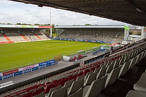
Stadion an der Hafenstraße
Stadium in Essen, Germany.
Distance: Approx. 726 meters
Latitude and longitude: 51.48666667,6.97638889
Stadion an der Hafenstraße, known as Stadion Essen until 2022, is a stadium in Essen, Germany. Located in the borough of Bergeborbeck, it has a capacity of 20,650 spectators. It is the home of Rot-Weiss Essen in the third-level men's 3.

Bäuminghausstraße station
Railway station in Germany
Distance: Approx. 1604 meters
Latitude and longitude: 51.4791,7.0036
Bäuminghausstraße is an underground station of the Essen Stadtbahn in Altenessen, Essen. Lines U11 and U17 call the station. It is located at the crossroads of Gladbecker Straße and Bäuminghausstraße.

Altenessen
Distance: Approx. 2517 meters
Latitude and longitude: 51.48333333,7.01666667
Altenessen is a northern borough of the city of Essen, Germany. Officially it is divided into the two boroughs of Altenessen-Nord (Altenessen-North) and Altenessen-Süd (Altenessen-South). Because of its size, Altenessen was divided into two parts, when it was incorporated into the city of Essen in 1915.

Bamlerstraße station
Railway station in Germany
Distance: Approx. 1539 meters
Latitude and longitude: 51.47447,7.00042
Bamlerstraße is an underground station of the Essen Stadtbahn on the boundaries of Altenessen and Nordviertel, both being boroughs of Essen. Lines U11 and U17 call the station, as well as bus line 196. It is located at the crossroads of Bamlerstraße and Riedingerstraße.
Altendorf, Essen
Borough of Essen in Wahlkreis 67, Stadtbezirk III
Distance: Approx. 2226 meters
Latitude and longitude: 51.46083306,6.97694389
Altendorf (lit. "old village") is a northwestern borough of the city of Essen, Germany. It was incorporated into the city on 1 August 1901.

Bochold
Distance: Approx. 1108 meters
Latitude and longitude: 51.475,6.9675
Bochold is a northwestern borough of the city of Essen, Germany. It was incorporated into the city in 1915. Before it had been part of the Bürgermeisterei Borbeck (Borbeck district).

Karlsplatz station (Essen)
Underground station in Altenessen, Essen
Distance: Approx. 2535 meters
Latitude and longitude: 51.5,7
Karlsplatz is an underground station of the Essen Stadtbahn in Altenessen, Essen. Lines U11 and U17 call the station as well as buses 172, 173, and 183. It is located below Altenessener Straße at the crossroads of Johanniskirchstraße.

Krupp steelworks
Historic German industrial site
Distance: Approx. 2375 meters
Latitude and longitude: 51.46,6.988889
The Krupp steelworks, or Krupp foundry, or Krupp cast steel factory (German: Krupp-Gussstahlfabrik [Guss+stahl+fabrik]) in Essen is a historic industrial site of the Ruhr area of North Rhine-Westphalia in western Germany that was known as the "weapons forge of the German Reich" (Waffenschmiede des Deutschen Reiches).
Weather in this IP's area
clear sky
6 Celsius
6 Celsius
5 Celsius
7 Celsius
1026 hPa
83 %
1026 hPa
1020 hPa
10000 meters
0.45 m/s
1.34 m/s
90 degree
07:38:23
16:53:22

