Country:
Region:
City:
Latitude and Longitude:
Time Zone:
Postal Code:
IP information under different IP Channel
ip-api
Country
Region
City
ASN
Time Zone
ISP
Blacklist
Proxy
Latitude
Longitude
Postal
Route
Luminati
Country
City
pristina
ASN
Time Zone
Europe/Belgrade
ISP
TelKos L.L.C
Latitude
Longitude
Postal
IPinfo
Country
Region
City
ASN
Time Zone
ISP
Blacklist
Proxy
Latitude
Longitude
Postal
Route
db-ip
Country
Region
City
ASN
Time Zone
ISP
Blacklist
Proxy
Latitude
Longitude
Postal
Route
ipdata
Country
Region
City
ASN
Time Zone
ISP
Blacklist
Proxy
Latitude
Longitude
Postal
Route
Popular places and events near this IP address

Vushtrri
City in Kosovo
Distance: Approx. 186 meters
Latitude and longitude: 42.82222222,20.96944444
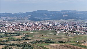
Vushtrri (Albanian definite form: Vushtrria; Serbian Cyrillic: Вучитрн, Vučitrn) is a city and municipality located in the Mitrovica District in Kosovo. According to the 2011 census, the town of Vushtrri has 26,964 inhabitants, while the municipality has 69,870 inhabitants. Vushtrri is surrounded by the city of Mitrovica to the north, Podujevë in the east, Obiliq in the south, Drenas in the south-west, and Skenderaj in the west.
Ferki Aliu Stadium
Distance: Approx. 760 meters
Latitude and longitude: 42.81882,20.974744
Ferki Aliu Stadium (Albanian: Stadiumi Ferki Aliu), is a multi-use stadium in Vushtrri, Kosovo. It is currently used for football matches and is the home ground of KF Vushtrria of the Kosovar Superliga. The stadium holds 6,000 people.

Vushtrri Castle
Castle in Vushtrri, Kosovo
Distance: Approx. 98 meters
Latitude and longitude: 42.82222222,20.9675
The Vushtrri Castle (Albanian: Kalaja e Vushtrrisë; Serbian: Војиновића Кула) or Old Tower (Albanian: Kulla e Vjetër; Serbian: Vojinovića Kula) are city fortifications in Vushtrri, Kosovo. It was the seat of despot Đurađ Branković (1427–1456). Later chroniclers (Ami Boué, Aleksandar Giljferding) are noted that the fort itself is derived from the times of Dušan, and that it is an old fortress with a tower in the middle of the town.

Stone Bridge, Vushtrri
Cultural heritage monument of Kosovo
Distance: Approx. 590 meters
Latitude and longitude: 42.8236,20.9603
The Stone Bridge (Albanian: Ura e Vjetër e Gurit - Ura me Nëntë Harqe) or Vojinović Bridge (Serbian: Vojinovića most, Serbian Cyrillic: Војиновића мост) is a medieval bridge located in Vushtrri (Serbian: Vučitrn), Kosovo. It dates from the end of the 14th or early 15th century, and according to legend, was built by two brothers from the Vojinović noble family. The brothers are mentioned in Serbian epic poetry as nephews of Tsar Dušan, who ruled as King of Serbia from 1331–1346 and as Serbian Emperor from 1346–1355.

Gojbulja
Village in District of Mitrovica, Kosovo
Distance: Approx. 3483 meters
Latitude and longitude: 42.84888889,20.99166667
Gojbulja (Serbian Cyrillic: Гојбуља) or Gojbulë is a settlement in the Vushtrri municipality of Kosovo. The rural settlement lies on a cadastral area with the same name, with 692 hectares. It lies 687 m above sea level.

Viciana
Ancient Roman road station mansio in the Kosovo field
Distance: Approx. 186 meters
Latitude and longitude: 42.822222,20.969444
Viciana (Latin: Viziana - Vizianum) or Station Viciano was a Roman road station (mansio type) of unclear location, somewhere in Kosovo field.
Bukosh, Vushtrri
Village in Mitrovicë, Kosovo
Distance: Approx. 3863 meters
Latitude and longitude: 42.80305556,20.92888889
Bukosh (Albanian: Bukoshi), is a village in the Vushtrri municipality in Kosovo. It is inhabited by a majority of ethnic Albanians.
Sllatina, Vushtrri
Village in Mitrovicë, Kosovo
Distance: Approx. 3338 meters
Latitude and longitude: 42.85305556,20.96944444
Sllatinë or Slatina (Serbian Cyrillic : Слатина) is a village in Kosovo located in the municipality of Vushtrri and in the district of Mitrovicë. According to the Kosovo census of 2011, it has 491 inhabitants, all of whom are Albanians.
Old Hamam (Vushtrri)
Cultural heritage monument in Vushtrri, Kosovo
Distance: Approx. 306 meters
Latitude and longitude: 42.82166667,20.96430556
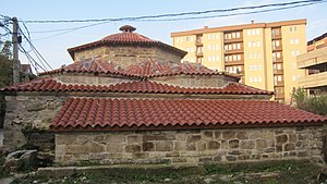
The Old Hamam of Vushtrri (also known as the Gazi Ali Bey Hamam) is one of the oldest and most prominent monuments in Vushtrri, Kosovo.

City Tekke (Vushtrri)
Tomb in Vushtrri, Kosovo
Distance: Approx. 379 meters
Latitude and longitude: 42.821111,20.971269
The City Tekke of Vushtrri is a tomb and a cultural heritage monument in Vushtrri, Kosovo. It is named a teqe or tekke because the local Sufi monastery or khanqah, so named in the region, is nearby.
Former Historical Archive (Vushtrri)
Cultural heritage monument of Kosovo
Distance: Approx. 240 meters
Latitude and longitude: 42.82253,20.96467
The Former Historical Archive is a cultural heritage monument in Vushtrri, Kosovo.

Gazi Ali Beg Mosque
Old mosque in Vushtrri, Kosovo
Distance: Approx. 390 meters
Latitude and longitude: 42.82086,20.96382
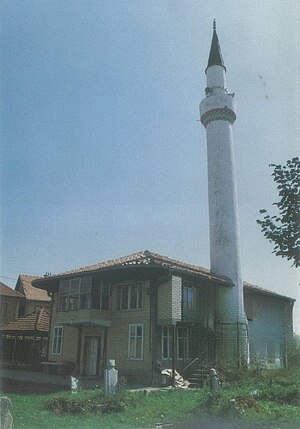
Gazi Ali Beg Mosque (Albanian: Xhamia e Gazi Ali Beut) is a mosque located in the old core of the city of Vushtrri, 100 m away from the Old Hammam, as part of the Gazi Ali Beg Complex. Built in the 15th century, it is one of the oldest cultural heritage monuments in Kosovo.
Weather in this IP's area
overcast clouds
4 Celsius
2 Celsius
4 Celsius
4 Celsius
1026 hPa
55 %
1026 hPa
962 hPa
10000 meters
1.92 m/s
1.85 m/s
30 degree
100 %
06:22:04
16:18:12

