Country:
Region:
City:
Latitude and Longitude:
Time Zone:
Postal Code:
IP information under different IP Channel
ip-api
Country
Region
City
ASN
Time Zone
ISP
Blacklist
Proxy
Latitude
Longitude
Postal
Route
Luminati
Country
City
prizren
ASN
Time Zone
Europe/Belgrade
ISP
Artmotion Sh.p.k.
Latitude
Longitude
Postal
IPinfo
Country
Region
City
ASN
Time Zone
ISP
Blacklist
Proxy
Latitude
Longitude
Postal
Route
db-ip
Country
Region
City
ASN
Time Zone
ISP
Blacklist
Proxy
Latitude
Longitude
Postal
Route
ipdata
Country
Region
City
ASN
Time Zone
ISP
Blacklist
Proxy
Latitude
Longitude
Postal
Route
Popular places and events near this IP address

Camp Casablanca
Military base in Kosovo
Distance: Approx. 1185 meters
Latitude and longitude: 42.34805556,20.82305556
Camp Casablanca (Albanian: Kampi Casablanka), also known as The Damper Unit (Albanian: Njësia Damper) is a military base located in the city of Suva Reka, Kosovo.

Suva Reka
Town and municipality in Prizren, Kosovo
Distance: Approx. 2395 meters
Latitude and longitude: 42.38,20.82194444
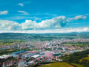
Suva Reka (Serbian Cyrillic: Сува Река) or Suharekë (Albanian definite form: Suhareka) or Therandë (Albanian definite form: Theranda) is a town and municipality located in the Prizren district of central-southern Kosovo. According to the 2011 census, the town has 10,422 inhabitants, while the municipality has 59,722 inhabitants. Suva Reka is located 18 km (11 mi) from the city of Prizren, and 57 km (35 mi) from Kosovo's capital, Pristina.
Studençan
Village in Prizren District, Kosovo
Distance: Approx. 5461 meters
Latitude and longitude: 42.35861111,20.75861111
Studençan (Serbian: Studenčane, Serbian Cyrillic: Студенчане) is a village in the municipality of Suva Reka, Kosovo. The new name was given after the Kosovo War. Studençan is close to Suva Reka, 5 km west.
Trnje, Suva Reka
Village in Prizren, Kosovo
Distance: Approx. 5833 meters
Latitude and longitude: 42.33,20.7656
Trnje/Termje is a village in the municipality of Suva Reka/Suharekë, Kosovo.
Topliçan
Village in Prizren, Kosovo
Distance: Approx. 4173 meters
Latitude and longitude: 42.325,20.8025
Topliçan is a settlement in the Therandë municipality in Kosovo. It lies 413 m above sea level. It has an ethnic Albanian majority, and Serbian minority; in the 1981 census, it had 307 inhabitants.
Leshan, Kosovo
Village in Prizren, Kosovo
Distance: Approx. 4981 meters
Latitude and longitude: 42.32777778,20.78111111
Lešane Albanian: Leshanis a settlement in the Suhareka municipality in south Kosovo. It is located in the Prizren region. It lies 374 m above sea level.
Reçan, Suhareka
Village in Prizren, Kosovo
Distance: Approx. 3477 meters
Latitude and longitude: 42.36,20.86722222
Reçan (Serbian Cyrillic: Речане, Albanian: Reçan), or Reqan, is a settlement in the Suva Reka (Suhareka) municipality in Kosovo. The rural settlement lies 483 m above sea level in a cadastral area of the same name, covering 679 hectares. It has an ethnic Albanian majority.
Church of the Holy Apostles Peter and Paul, Suva Reka
Distance: Approx. 590 meters
Latitude and longitude: 42.36152778,20.83097222
Church of Holy Apostles Peter and Paul was a Serbian Orthodox church located in Suva Reka, city and seat of the eponymous municipality in central Kosovo and Metohija. The church was built in 1938, and it belonged to the Diocese of Raška and Prizren of the Serbian Orthodox Church. Upon arrival of the German KFOR troops in the area of Suva Reka in June 1999, and when Albanians took over administration of the town, the church was vandalized and looted.
Gjinoc
Village in Prizren, Kosovo
Distance: Approx. 4499 meters
Latitude and longitude: 42.318482,20.81837
Gjinoc (Albanian: Gjinoc/Gjinaj, Serbian Cyrillic: Ђиновце/Đinovce) is a village in Suharekë municipality, Kosovo.
Peqan
Village in Prizren, Kosovo
Distance: Approx. 2665 meters
Latitude and longitude: 42.382499,20.823013
Peqan (Albanian: Peqan, Serbian Cyrillic: Пећане/Pećane) is a village in Suharekë municipality, Kosovo.
Sopi, Suva Reka
Village in Prizren, Kosovo
Distance: Approx. 2983 meters
Latitude and longitude: 42.335606,20.843629
Sopi or Sopijë (Albanian: Sopi, Serbian Cyrillic: Сопина/Sopina) is a village in Suharekë municipality, Kosovo.
Suva Reka City Stadium
Distance: Approx. 629 meters
Latitude and longitude: 42.353253,20.822536
The Theranda City Stadium (Albanian: Stadiumi i Qytetit të Suharekës) is a soccer-specific stadium in Suva Reka, Kosovo. It is currently used mostly for football matches and is the home ground of FC Ballkani in the Football Superleague of Kosovo.
Weather in this IP's area
scattered clouds
4 Celsius
2 Celsius
4 Celsius
4 Celsius
1023 hPa
56 %
1023 hPa
977 hPa
10000 meters
2.16 m/s
2.47 m/s
30 degree
34 %
06:29:07
16:14:11