185.171.57.170 - IP Lookup: Free IP Address Lookup, Postal Code Lookup, IP Location Lookup, IP ASN, Public IP
Country:
Region:
City:
Location:
Time Zone:
Postal Code:
ISP:
ASN:
language:
User-Agent:
Proxy IP:
Blacklist:
IP information under different IP Channel
ip-api
Country
Region
City
ASN
Time Zone
ISP
Blacklist
Proxy
Latitude
Longitude
Postal
Route
db-ip
Country
Region
City
ASN
Time Zone
ISP
Blacklist
Proxy
Latitude
Longitude
Postal
Route
IPinfo
Country
Region
City
ASN
Time Zone
ISP
Blacklist
Proxy
Latitude
Longitude
Postal
Route
IP2Location
185.171.57.170Country
Region
england
City
clayton
Time Zone
Europe/London
ISP
Language
User-Agent
Latitude
Longitude
Postal
ipdata
Country
Region
City
ASN
Time Zone
ISP
Blacklist
Proxy
Latitude
Longitude
Postal
Route
Popular places and events near this IP address

Hassocks
Village and parish in West Sussex, England
Distance: Approx. 1314 meters
Latitude and longitude: 50.923303,-0.150863
Hassocks is a village and civil parish in the Mid Sussex District of West Sussex, England. Its name is believed to derive from the tufts of grass found in the surrounding fields. Located approximately 7 miles (11 km) north of Brighton, with a population of 8,319, the area now occupied by Hassocks was just a collection of small houses and a coaching house until the 19th century, when work started on the London to Brighton railway.

Hassocks railway station
Railway station in West Sussex, England
Distance: Approx. 1595 meters
Latitude and longitude: 50.925,-0.14583333
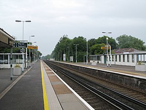
Hassocks railway station is on the Brighton Main Line in England, serving the village of Hassocks, West Sussex. It is 43 miles 42 chains (70.0 km) down the line from London Bridge via Redhill and is situated between Burgess Hill and Preston Park. It is managed by Southern.
Hassocks F.C.
Association football club in England
Distance: Approx. 931 meters
Latitude and longitude: 50.91972222,-0.15055556
Hassocks Football Club is a football club based in Hassocks, near Brighton, West Sussex, England. The club is affiliated to the Sussex County Football Association. The club joined the Sussex County League Division Two in 1981 and has reached the 2nd round of the FA Vase three times in its history, and the 3rd qualifying round of the FA Cup in 2001–02.
Clayton Tunnel rail crash
1861 railway accident near Brighton, England
Distance: Approx. 123 meters
Latitude and longitude: 50.91277778,-0.15388889
The Clayton Tunnel rail crash occurred on Sunday 25 August 1861, five miles (8 km) from Brighton on the south coast of England. At the time it was the worst accident on the British railway system. A train ran into the back of another inside the tunnel, killing 23 and injuring 176 passengers.

Pyecombe
Village and parish in West Sussex, England
Distance: Approx. 1584 meters
Latitude and longitude: 50.89883,-0.16394
Pyecombe is a village and civil parish in the Mid Sussex District of West Sussex, England. Pyecombe is located 7 miles (11 km) to the north of Brighton. The civil parish covers an area of 887 hectares (2,190 acres) and has a population of 200 (2001 census), increasing at the 2011 Census to a population of 237.

Clayton Tunnel
Railway tunnel in England
Distance: Approx. 123 meters
Latitude and longitude: 50.91277778,-0.15388889
Clayton Tunnel is a railway tunnel located near the villages of Clayton and Pyecombe in West Sussex, between Hassocks and Preston Park railway stations on the Brighton Main Line. This tunnel is notable for its turreted and castellated north portal with a single-storey cottage on the top, as well as for being the site of a serious accident in 1861 which was influential in the adoption of a robust signalling system in the UK and elsewhere. At 1 mile 499 yards (2,066 m) the Sussex Clayton Tunnel is the longest tunnel on the route.

Wolstonbury Hill
Protected area in West Sussex, England
Distance: Approx. 1484 meters
Latitude and longitude: 50.909,-0.175
Wolstonbury Hill is a 58.9-hectare (146-acre) biological Site of Special Scientific Interest south-west of in West Sussex. It is owned by the National Trust and part of it is a Scheduled Monument.
Clayton Windmills
Three windmills in West Sussex, England
Distance: Approx. 867 meters
Latitude and longitude: 50.9052,-0.1475
The Clayton Windmills, known locally as Jack and Jill, stand on the South Downs above the village of Clayton, West Sussex, England. They comprise a post mill and a tower mill, and the roundhouse of a former post mill. All three are Grade II* listed buildings.
Clayton, West Sussex
Village in West Sussex, England
Distance: Approx. 231 meters
Latitude and longitude: 50.91041,-0.15173
Clayton is a small village and former civil parish, now in the parish of Hassocks, in the Mid Sussex district, in the county of West Sussex, England. It lies at the foot of the South Downs, 41 miles (66 km) south of London, 6 miles (10 km) north of Brighton, and 28 miles (45 km) east northeast of the county town of Chichester. Other nearby towns include Burgess Hill to the north and Lewes, the county town of East Sussex east southeast.

Danny House
Grade I listed Elizabethan red brick mansion in West Sussex, England
Distance: Approx. 1573 meters
Latitude and longitude: 50.91916667,-0.17333333
Danny House is a Grade I listed Elizabethan red brick mansion near Hurstpierpoint in West Sussex, England. It lies at the northern foot of Wolstonbury Hill and may be regarded as one of the finest stately houses in Sussex, with 56 bedrooms and 28 apartments. The present house was built 1593–95 by George Goring, on the site of an older house.

Downlands Community School
Community school in Hassocks, West Sussex, England
Distance: Approx. 1529 meters
Latitude and longitude: 50.92129,-0.13871
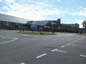
Downlands Community School is a maintained comprehensive for pupils aged 11 to 16. It has about 1200 pupils. In October 2022, Ofsted inspected the school and reported that the school was 'good' in all areas.

St John the Baptist's Church, Clayton
Church in West Sussex, England
Distance: Approx. 148 meters
Latitude and longitude: 50.9105,-0.1534
St John the Baptist's Church is the Church of England parish church of the village of Clayton in Mid Sussex District, one of seven local government districts in the English county of West Sussex. The small and simple Anglo-Saxon building is distinguished by its "remarkable" and extensive set of wall paintings, dating from the early 12th century and rediscovered more than 700 years later. Much of the structural work of the church is 11th-century and has had little alteration.
Weather in this IP's area
light rain
4 Celsius
4 Celsius
2 Celsius
4 Celsius
1006 hPa
96 %
1006 hPa
1001 hPa
10000 meters
0.89 m/s
1.79 m/s
25 degree
100 %

