185.171.45.115 - IP Lookup: Free IP Address Lookup, Postal Code Lookup, IP Location Lookup, IP ASN, Public IP
Country:
Region:
City:
Location:
Time Zone:
Postal Code:
IP information under different IP Channel
ip-api
Country
Region
City
ASN
Time Zone
ISP
Blacklist
Proxy
Latitude
Longitude
Postal
Route
Luminati
Country
ASN
Time Zone
Europe/Berlin
ISP
Medialine EuroTrade AG
Latitude
Longitude
Postal
IPinfo
Country
Region
City
ASN
Time Zone
ISP
Blacklist
Proxy
Latitude
Longitude
Postal
Route
IP2Location
185.171.45.115Country
Region
hessen
City
kastel
Time Zone
Europe/Berlin
ISP
Language
User-Agent
Latitude
Longitude
Postal
db-ip
Country
Region
City
ASN
Time Zone
ISP
Blacklist
Proxy
Latitude
Longitude
Postal
Route
ipdata
Country
Region
City
ASN
Time Zone
ISP
Blacklist
Proxy
Latitude
Longitude
Postal
Route
Popular places and events near this IP address

Deutschhaus Mainz
Historical building in Mainz, Germany
Distance: Approx. 954 meters
Latitude and longitude: 50.00527778,8.27166667
The Deutschhaus or Deutschordenskommende (German for "Commandry of the Teutonic Knights") is a historical building in Mainz, western Germany, which is the seat of the Landtag of Rhineland-Palatinate.
Mainz-Kastel
Borough of Wiesbaden in Hesse, Germany
Distance: Approx. 112 meters
Latitude and longitude: 50.00972222,8.28444444
Mainz-Kastel is a district of the city Wiesbaden, which is the capital of the German state Hesse in western Germany. Kastel is the historical bridgehead of Mainz, the capital of the German state Rhineland-Palatinate and is located on the right side of the Rhine river. Kastel faces the historical center of Mainz and the two cities are connected by a road bridge.

Theodor Heuss Bridge (Mainz-Wiesbaden)
Distance: Approx. 558 meters
Latitude and longitude: 50.00666667,8.27694444
The Theodor Heuss Bridge is an arch bridge over the Rhine River connecting the Mainz-Kastel district of Wiesbaden, capital of state Hesse and the Rhineland-Palatinate state capital Mainz. The main span of the bridge is 102.94 meters (337.7 ft) long. It connects the Bundesstraßes 40 and 455.
Stadion in der Witz
Distance: Approx. 559 meters
Latitude and longitude: 50.00888889,8.29055556
The Stadion in der Witz is a stadium in Mainz-Kastel, Wiesbaden, Germany, with a capacity of 5,000. It is currently used for football matches and is the home ground of FVgg Kastel 06.

Römisch-Germanisches Zentralmuseum
Archaeological research institute and museum in Mainz
Distance: Approx. 1033 meters
Latitude and longitude: 50.00611111,8.26972222
The Römisch-Germanisches Zentralmuseum (RGZM), Leibniz Research Institute for Archaeology, is headquartered in Mainz. It is supported by the Federal Republic of Germany and its states and is a member of the Leibniz Association of German research institutions. The institution studies the Old World and its contact zones from the Stone Age to the Middle Ages.

Iron Tower
Distance: Approx. 1111 meters
Latitude and longitude: 50.00111111,8.27555556
The Iron Tower (German: Eisenturm) is a mediaeval tower dating to the early 13th century, and modified in the 15th century, which with the Wood Tower and the Alexander Tower is one of three remaining towers from the city walls of Mainz, Germany. Its name derives from the Iron Market (Eisenmarkt), which was held in the immediate vicinity until the 19th century. The Iron Tower served as a watchtower and gate to the city, and later as a gaol.

Mainz-Kastel station
Railway station in Mainz, Germany
Distance: Approx. 330 meters
Latitude and longitude: 50.00694444,8.2825
Mainz-Kastel station is situated on the Frankfurt–Wiesbaden line (line number 3603; timetable section 645.1) in Mainz-Kastel, now a suburb of Wiesbaden, in the German state of Hesse. It was opened as part of the Taunus Railway, which was opened in 1839/40. The station was opened as part of the last stage of construction of the line to Wiesbaden and was opened on 19 May 1840.

St. Christoph's Church, Mainz
Distance: Approx. 1174 meters
Latitude and longitude: 50.0019,8.2722
The church of St. Christoph in Mainz, known in German as St. Christoph zu Mainz, is an example of early gothic architecture.
European Technical Center
Distance: Approx. 382 meters
Latitude and longitude: 50.0114,8.2877
The European Technical Center (ETC) is a U.S. National Security Agency (NSA) signals intelligence facility in Mainz-Kastel, Wiesbaden, Germany. Located in Building 4009 of the U.S. Army's Mainz-Kastel Storage Station, the facility serves as the NSA's "primary communications hub" in Europe. The center was known by the code name "GODLIKELESION".

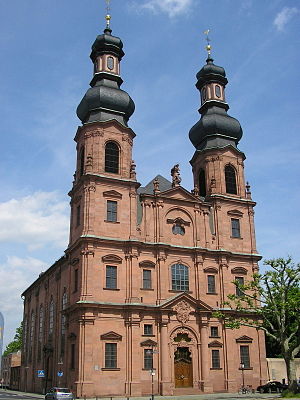
St. Peter's Church, Mainz
Building in Mainz, Germany
Distance: Approx. 1088 meters
Latitude and longitude: 50.004722,8.27
St. Peter's Church (in German Peterskirche) is located beneath Deutschhaus Mainz in the northwest of the historical center of Mainz, Germany. It is one of the most important rococo buildings in Mainz.

Martinsburg, Mainz
Distance: Approx. 912 meters
Latitude and longitude: 50.0068,8.2711
The Martinsburg is a former plains castle in Mainz. It lay on the banks of the Rhine, adjacent to the space where the Electoral Palace now stands.

Arsenal, Mainz
Distance: Approx. 992 meters
Latitude and longitude: 50.00444444,8.27194444
The Old Arsenal (Altes Zeughaus), also referred to as Zum Sautanz, was the central arsenal of the fortress of Mainz during the 17th and 18th century. In his function it was succeeded by the new arsenal. Currently the renaissance building is used by the Rhineland-Palatinate state chancellery and the Landtag of Rhineland-Palatinate.
Weather in this IP's area
broken clouds
1 Celsius
-1 Celsius
1 Celsius
3 Celsius
1020 hPa
97 %
1020 hPa
1008 hPa
10000 meters
2.57 m/s
270 degree
75 %
