185.171.36.26 - IP Lookup: Free IP Address Lookup, Postal Code Lookup, IP Location Lookup, IP ASN, Public IP
Country:
 Italy
ItalyRegion:
City:
Location:
Time Zone:
Postal Code:
ISP:
ASN:
language:
User-Agent:
Proxy IP:
Blacklist:
IP information under different IP Channel
ip-api
Country
Region
City
ASN
Time Zone
ISP
Blacklist
Proxy
Latitude
Longitude
Postal
Route
db-ip
Country
Region
City
ASN
Time Zone
ISP
Blacklist
Proxy
Latitude
Longitude
Postal
Route
IPinfo
Country
Region
City
ASN
Time Zone
ISP
Blacklist
Proxy
Latitude
Longitude
Postal
Route
IP2Location
185.171.36.26Country
itRegion
veneto
City
san bonifacio
Time Zone
Europe/Rome
ISP
Language
User-Agent
Latitude
Longitude
Postal
ipdata
Country
Region
City
ASN
Time Zone
ISP
Blacklist
Proxy
Latitude
Longitude
Postal
Route
Popular places and events near this IP address

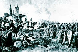
Battle of Arcole
1796 battle during the War of the First Coalition
Distance: Approx. 4450 meters
Latitude and longitude: 45.35722222,11.2775
The Battle of Arcole or Battle of Arcola (15–17 November 1796) was fought between French and Austrian forces 25 kilometres (16 mi) southeast of Verona during the War of the First Coalition, a part of the French Revolutionary Wars. The battle saw a bold maneuver by Napoleon Bonaparte's French Army of Italy to outflank the Austrian army led by József Alvinczi and cut off its line of retreat. The French victory proved to be a highly significant event during the third Austrian attempt to lift the siege of Mantua.
Battle of Caldiero (1805)
1805 Battle during the War of the Third Coalition
Distance: Approx. 7925 meters
Latitude and longitude: 45.42388889,11.19055556
The Battle of Caldiero took place on 30 October 1805, pitting the French Armée d'Italie under Marshal André Masséna against an Austrian army under the command of Archduke Charles, Duke of Teschen. The French engaged only some of their forces, around 33,000 men, but Archduke Charles engaged the bulk of his army, 49,000 men, leaving out Paul Davidovich's corps to defend the lower Adige and Franz Seraph of Orsini-Rosenberg's corps to cover the Austrian right against any flanking maneuvers. The fighting took place at Caldiero, 15 kilometres east of Verona, during the War of the Third Coalition, part of the Napoleonic Wars.

Arcole
Comune in Veneto, Italy
Distance: Approx. 4295 meters
Latitude and longitude: 45.35833333,11.28611111
Arcole (pronounced [ˈarkole]), historically also known as Arcola, is a comune with 5,274 inhabitants in the province of Verona. It is known as the site of the Battle of the Bridge of Arcole.

Belfiore
Comune in Veneto, Italy
Distance: Approx. 6769 meters
Latitude and longitude: 45.38333333,11.2
Belfiore is a comune in the province of Verona, Veneto, northern Italy.

Colognola ai Colli
Comune in Veneto, Italy
Distance: Approx. 7742 meters
Latitude and longitude: 45.43333333,11.2
Colognola ai Colli is a comune (municipality) in the Province of Verona in the Italian region Veneto, located about 90 kilometres (56 mi) west of Venice and about 15 kilometres (9 mi) east of Verona. Colognola ai Colli borders the following municipalities: Belfiore, Caldiero, Cazzano di Tramigna, Illasi, Lavagno, and Soave.

Ronco all'Adige
Comune in Veneto, Italy
Distance: Approx. 8126 meters
Latitude and longitude: 45.33333333,11.23333333
Ronco all'Adige is a comune (municipality) in the Province of Verona in the Italian region Veneto, located about 90 kilometres (56 mi) west of Venice and about 25 kilometres (16 mi) southeast of Verona. As of 31 October 2018, it had a population of 6,002 and an area of 42.6 square kilometres (16.4 sq mi). Ronco all'Adige borders the following municipalities: Albaredo d'Adige, Belfiore, Isola Rizza, Oppeano, Palù, Roverchiara, and Zevio.

Villa Pisani, Bagnolo
UNESCO World Heritage Site in Veneto, Italy
Distance: Approx. 8115 meters
Latitude and longitude: 45.35714,11.371381
The Villa Pisani is a patrician villa designed by Italian Renaissance architect Andrea Palladio, located in Bagnolo, a hamlet in the comune of Lonigo in the Veneto region of Italy.
Perlini
Italian lorry manufacturer
Distance: Approx. 1268 meters
Latitude and longitude: 45.4054,11.2736
Perlini or Perlini Equipment SpA is an Italian off-road dump truck/lorry manufacturer. Established in 1957 by Roberto Perlini, Perlini is based in San Bonifacio. The company has two manufacturing facilities with a total area of 130.000 square meters in San Bonifacio and Gambellara.
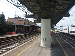
San Bonifacio railway station
Railway station in San Bonifacio, Italy
Distance: Approx. 1031 meters
Latitude and longitude: 45.4025,11.27388889
San Bonifacio (Italian: Stazione di San Bonifacio) is a railway station serving the town of San Bonifacio, in the region of Veneto, northern Italy. The station opened in 1886 and is located on the Milan–Venice railway. The train services are operated by Trenitalia.
Lonigo railway station
Railway station in Italy
Distance: Approx. 5168 meters
Latitude and longitude: 45.41305556,11.34638889
Lonigo (Italian: Stazione di Lonigo) is a railway station serving the town of Lonigo, in the region of Veneto, northern Italy. The station is located on the Milan–Venice railway. The train services are operated by Trenitalia.

Certosa di Pontignano
Monastery in Pontignano, Italy
Distance: Approx. 6652 meters
Latitude and longitude: 45.36923333,11.35981111
The Certosa di Pontignano (literally, 'Pontignano Charterhouse'), also known as the Certosa di San Pietro ('Saint Peter's Charterhouse'), is a Carthusian monastery and church in the neighborhood of Pontignano, within the town limits of Castelnuovo Berardenga, a few kilometers north of the city of Siena, in the region of Tuscany, Italy. The monastic complex, after the expulsion of the monks in 1810, passed through various hands, until it was acquired in 1959 by the University of Siena, and used for academic meetings, conventions, and also hotel and restaurant for events such as weddings and celebrations.

Battle of Forano
Battle of the Third Coalition
Distance: Approx. 7925 meters
Latitude and longitude: 45.42388889,11.19055556
The Battle of Forano took place during the War of the Third Coalition on 2 November 1805 which saw a decisive French victory by the Armée d'Italie under the command of Marshal André Masséna and General Jean-Baptiste Solignac over the Austrian troops led by Major general Karl Hillinger.
Weather in this IP's area
overcast clouds
9 Celsius
9 Celsius
9 Celsius
9 Celsius
1022 hPa
92 %
1022 hPa
1013 hPa
10000 meters
0.53 m/s
0.55 m/s
4 degree
99 %