185.171.166.118 - IP Lookup: Free IP Address Lookup, Postal Code Lookup, IP Location Lookup, IP ASN, Public IP
Country:
Region:
City:
Location:
Time Zone:
Postal Code:
ISP:
ASN:
language:
User-Agent:
Proxy IP:
Blacklist:
IP information under different IP Channel
ip-api
Country
Region
City
ASN
Time Zone
ISP
Blacklist
Proxy
Latitude
Longitude
Postal
Route
db-ip
Country
Region
City
ASN
Time Zone
ISP
Blacklist
Proxy
Latitude
Longitude
Postal
Route
IPinfo
Country
Region
City
ASN
Time Zone
ISP
Blacklist
Proxy
Latitude
Longitude
Postal
Route
IP2Location
185.171.166.118Country
Region
andalucia
City
cordoba
Time Zone
Europe/Madrid
ISP
Language
User-Agent
Latitude
Longitude
Postal
ipdata
Country
Region
City
ASN
Time Zone
ISP
Blacklist
Proxy
Latitude
Longitude
Postal
Route
Popular places and events near this IP address

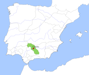
Taifa of Córdoba
Distance: Approx. 5 meters
Latitude and longitude: 37.88333333,-4.76666667
The Taifa of Córdoba (Arabic: طائفة قرطبة) was an Arab taifa which was ruled by the Banu Jawhar that replaced the Umayyad Caliph as the government of Córdoba and its vicinity in 1031.

San Pedro (Córdoba)
Distance: Approx. 462 meters
Latitude and longitude: 37.8827,-4.7719
San Pedro (St Peter) is a minor basilica in Córdoba, Spain. The church is located in the square of the barrio (quarter) bearing its name.

Plaza del Potro
Distance: Approx. 756 meters
Latitude and longitude: 37.881,-4.7748
The Plaza del Potro is a public square in the Spanish city of Córdoba. Rectangular in shape, one end of the plaza has a fountain topped by the figure of a colt with its front legs raised holding a sign with the coat of arms of the city. This Renaissance-style fountain dates from 1577, and the colt which gives its name to the square was added a century later.

San Lorenzo, Córdoba
Distance: Approx. 585 meters
Latitude and longitude: 37.88833333,-4.76861111
San Lorenzo is a church in Córdoba, Andalusia, southern Spain. Situated in the historic centre, it was one of the twelve religious buildings commissioned by king Ferdinand III of Castile in the city after its conquest in the early 13th century. The church occupies the site of a pre-existing Islamic mosque, which in turn had been built above a Visigothic church.

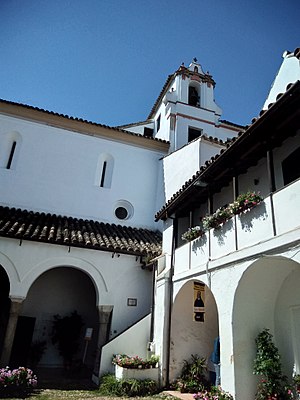
Convento de Santa Cruz (Córdoba)
Convent in Andalusia, Spain
Distance: Approx. 384 meters
Latitude and longitude: 37.88166667,-4.77055556
Convento de Santa Cruz is a convent situated in the historic centre, barrio de San Pedro, Córdoba, Andalusia, Spain. It was founded in 1435, by Pedro de los Ríos y Gutiérrez de Aguayo and his wife, Teresa Zurita. The building has always been closely linked to the Ríos family, which were adding new spaces to the original project, resulting in an interesting building composed of different structures organized around courtyards.

Convento de Santa Marta
Convent in Córdoba, Spain
Distance: Approx. 804 meters
Latitude and longitude: 37.8865,-4.7749
The Convento de Santa Marta is a convent in Córdoba, Spain, on Calle de Santa Marta. Founded in 1464, it belongs to the female branch of the order Hieronymites. Architecturally, the convent was built in the "Reyes Católicos" style and is characterized by its quadrangular nave covered by cross vaults, which highlight the altarpiece, made in the year 1582.

Santa María Magdalena, Córdoba
Distance: Approx. 309 meters
Latitude and longitude: 37.88527778,-4.76916667
Santa María Magdalena (St Mary Magdalene Church) is a church in Córdoba, Spain, built in the Mudejar style. It forms part of the Historic centre of Córdoba, a UNESCO World Heritage site, and is named after Jesus' companion, Mary Magdalene. The church of Santa Mariá Magdalena was one of the first of 12 churches Fernando III built after conquering Córdoba in 1236.

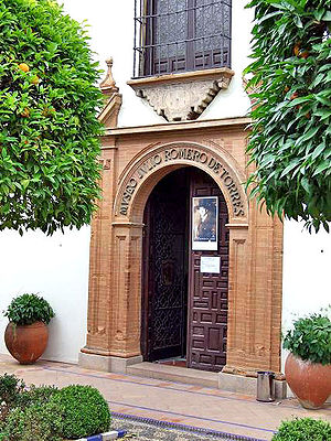
Julio Romero de Torres Museum
Museum in Córdoba, Spain
Distance: Approx. 749 meters
Latitude and longitude: 37.88133,-4.77485
The Julio Romero de Torres Museum is a museum located in the city of Córdoba, Spain, which is notable for containing the largest collection of the famous Cordoban painter Julio Romero de Torres. It is located in the building of the old Hospital of la Caridad, which also houses the Museum of Fine Arts of Córdoba. The museum has been declared a Bien de Interés Cultural in the category of monument since 1962.

Central District, Córdoba
Administrative district in Córdoba, Spain
Distance: Approx. 762 meters
Latitude and longitude: 37.887,-4.774
The Central District is one of the ten districts of Córdoba, Spain. it includes the central area of the city. The Central District is delimited to the west by Av.

Arco de Isabel II
Triumphal arch in Córdoba, Spain
Distance: Approx. 191 meters
Latitude and longitude: 37.88501111,-4.76688889
The Arch of Isabel II (in Spanish el Arco de Isabel II) was an ephemeral triumphal arch, now disappeared, located in Córdoba, Spain. This commemorative monument was built in front of the old Puerta Nueva in 1862. The reason for its construction was to welcome the arrival of Queen Isabel II to the city of Cordoba, which took place on September 14, 1862.

Axerquía
Historic eastern suburb in Spain
Distance: Approx. 572 meters
Latitude and longitude: 37.8865,-4.7718
Axerquía was the historic eastern suburb of the Historic centre of Córdoba (known at the time to the Arabs as Medina and the Christians as Villa). The Axerquía areas was also walled. Currently, Axerquía is an area within the city of Córdoba in Spain.
Fine Arts Museum of Córdoba
Art museum in Córdoba, Spain
Distance: Approx. 746 meters
Latitude and longitude: 37.88125,-4.774778
The Fine Arts Museum of Córdoba (Spanish: Museo de Bellas Artes de Córdoba) is a State-owned art museum located in the Spanish city of Córdoba.
Weather in this IP's area
drizzle
15 Celsius
15 Celsius
15 Celsius
15 Celsius
1019 hPa
100 %
1019 hPa
989 hPa
6000 meters
3.6 m/s
250 degree
100 %
