185.171.133.51 - IP Lookup: Free IP Address Lookup, Postal Code Lookup, IP Location Lookup, IP ASN, Public IP
Country:
Region:
City:
Location:
Time Zone:
Postal Code:
IP information under different IP Channel
ip-api
Country
Region
City
ASN
Time Zone
ISP
Blacklist
Proxy
Latitude
Longitude
Postal
Route
Luminati
Country
ASN
Time Zone
Asia/Hebron
ISP
Palestine Telecommunications Company (PALTEL)
Latitude
Longitude
Postal
IPinfo
Country
Region
City
ASN
Time Zone
ISP
Blacklist
Proxy
Latitude
Longitude
Postal
Route
IP2Location
185.171.133.51Country
Region
ramallah
City
al birah
Time Zone
Asia/Hebron
ISP
Language
User-Agent
Latitude
Longitude
Postal
db-ip
Country
Region
City
ASN
Time Zone
ISP
Blacklist
Proxy
Latitude
Longitude
Postal
Route
ipdata
Country
Region
City
ASN
Time Zone
ISP
Blacklist
Proxy
Latitude
Longitude
Postal
Route
Popular places and events near this IP address

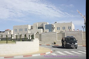
Mukataa
Arabic term for an administrative center
Distance: Approx. 1273 meters
Latitude and longitude: 31.91233333,35.20856389
Mukataa (Arabic: مقاطعة, romanized: muqāṭaʿah) is an Arabic word for headquarters or administrative center, particularly in Palestine. Mukataas were mostly built during the British Mandate as Tegart forts and were used both as British government centers and as dwellings for the British administrative staff. Some Mukataas also included police stations and prisons.
2000 Ramallah lynching
Lynching of two Israelis in the Israeli-occupied West Bank
Distance: Approx. 1550 meters
Latitude and longitude: 31.905,35.2044
The 2000 Ramallah lynching was an attack that took place early during the Second Intifada on 12 October 2000 in the Israeli-occupied West Bank, when a Palestinian crowd of passing funeral marchers broke in and killed two Israeli military reservists and then mutilated their bodies. The incident occurred during a funeral for a Palestinian child, Khalil Zahran, who had been killed by Israeli forces two days earlier. The two Israeli military reservists, Vadim Nurzhitz and Yosef "Yossi" Avrahami had accidentally entered the Palestinian Authority-controlled city of Ramallah in the West Bank, and were taken into custody by Palestinian Authority policemen, 13 of whom were injured while trying to stop the lynching.
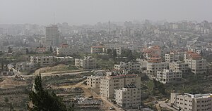
Al-Bireh
West Bank city in the Ramallah and Al-Bireh Governorate
Distance: Approx. 571 meters
Latitude and longitude: 31.90527778,35.215
Al-Bireh, al-Birah, or el-Bira (Arabic: البيرة; also known historically as Castrum Mahomeria, Magna Mahomeria, Mahomeria Major, Birra, or Beirothah) is a Palestinian city in the central West Bank, 15 kilometers (9.3 mi) north of Jerusalem. It is the capital of the Ramallah and al-Bireh Governorate of the State of Palestine. It is situated on the central ridge running through the West Bank and is 860 meters (2,820 ft) above sea level, covering an area of 22.4 square kilometers (8.6 sq mi).

Mateh Binyamin Regional Council
Israeli regional council in the West Bank
Distance: Approx. 884 meters
Latitude and longitude: 31.9,35.21666667
Mateh Binyamin Regional Council (Hebrew: מועצה אזורית מטה בנימין, Mo'atza Azorit Mateh Binyamin, Lit. Council for the Region of the Tribe of Benjamin) is a regional council governing 47 Israeli settlements and outposts in the West Bank. The council's jurisdiction is from the Jordan valley in the east to the Samarian foothills in the west, and from the Shiloh creek in the north to the Jerusalem Mountains in the south.

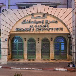
Al-Kasaba Theatre
Cinema in Ramallah, Palestine
Distance: Approx. 1662 meters
Latitude and longitude: 31.90246944,35.20392222
Al-Kasaba Theatre and Cinematheque (Arabic: القصبة مسرح وسينماتك) is a cinema in the city of Ramallah, West Bank, Palestine. It was established in 1970 during Israeli occupation for playwrights and eventually began presenting films. Al-Kasaba is the only official multipurpose cinema in the Palestinian territories.

Al-Am'ari
Refugee camp in Ramallah and al-Bireh, State of Palestine
Distance: Approx. 1696 meters
Latitude and longitude: 31.89405556,35.21153333
al-Am'ari Refugee Camp (Arabic: مخيّم الأمعري) is a Palestinian refugee camp in the Ramallah and al-Bireh Governorate, located 2 kilometers south of Al Bireh in the central West Bank. According to the Palestinian Central Bureau of Statistics (PCBS), the camp had a population of 4,725 inhabitants in 2017. The al-Am'ari camp has 10,377 registered refugees.
Psagot
Israeli settlement in the West Bank
Distance: Approx. 947 meters
Latitude and longitude: 31.89916667,35.22388889
Psagot (Hebrew: פְּסָגוֹת, lit. 'Peaks') is an Israeli settlement in the West Bank, located on Tawil hill, adjacent to the Palestinian cities of Ramallah and al-Bireh. Established in 1981, it is organised as a community settlement and falls under the jurisdiction of Binyamin Regional Council, with the council's headquarters located there. In 2022 it had a population of 2,086.

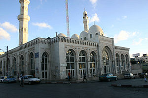
Jamal Abdel Nasser Mosque
Mosque in the city of Al-Bireh, Ramallah and Al-Bireh Governorate, Palestine
Distance: Approx. 1287 meters
Latitude and longitude: 31.90396389,35.20752222
Jamal Abdel Nasser Mosque (Arabic: مسجد جمال عبد الناصر Masjid Jamal 'Abd an-Nasser) is the largest mosque in al-Bireh, West Bank, Palestine. Located in the Downtown district of the city, the mosque is named after the late Egyptian president and Arab leader Gamal Abdel Nasser. On March 14, 2002, the Israeli Army (IDF) took over the mosque and used its minaret for sniping, killing four Palestinians.
Qaddura
Refugee Camp in Ramallah and al-Bireh, State of Palestine
Distance: Approx. 1556 meters
Latitude and longitude: 31.90092222,35.20588333
Qaddura Refugee Camp (Arabic: مخيّم قدورة) is a Palestinian refugee camp in the Ramallah and al-Bireh Governorate, located just outside downtown Ramallah in the central West Bank. According to the Palestinian Central Bureau of Statistics (PCBS), the Camp had a population of 924 inhabitants in 2017. Qaddura camp was established in 1948, but is not recognized as an official UNRWA camp.

Al-Manara Square
Square in Ramallah, West Bank, Palestine
Distance: Approx. 1546 meters
Latitude and longitude: 31.905,35.20444444
Al-Manara Square (Arabic: ميدان المنارة) is a town square located in Ramallah, West Bank, Palestine.
List of ambassadors of China to the State of Palestine
Distance: Approx. 1797 meters
Latitude and longitude: 31.905843,35.201653
The Chinese Ambassador to Palestine is the official representative of the People's Republic of China to the State of Palestine.
Majed Asad Stadium
Football stadium in Al-Bireh, Palastine
Distance: Approx. 391 meters
Latitude and longitude: 31.90694444,35.22472222
Majed Asad Stadium is a football stadium in Al-Bireh, Palestine. The stadium's construction was funded with aid from the French and German governments, and French footballer Lilian Thuram participated in the inauguration, taking the first kick of the Palestine Cup final.
Weather in this IP's area
clear sky
12 Celsius
11 Celsius
12 Celsius
12 Celsius
1014 hPa
50 %
1014 hPa
936 hPa
10000 meters
3.45 m/s
4.9 m/s
245 degree
2 %

