185.170.249.38 - IP Lookup: Free IP Address Lookup, Postal Code Lookup, IP Location Lookup, IP ASN, Public IP
Country:
Region:
City:
Location:
Time Zone:
Postal Code:
IP information under different IP Channel
ip-api
Country
Region
City
ASN
Time Zone
ISP
Blacklist
Proxy
Latitude
Longitude
Postal
Route
Luminati
Country
Region
18
City
moirana
ASN
Time Zone
Europe/Oslo
ISP
Telemix AS
Latitude
Longitude
Postal
IPinfo
Country
Region
City
ASN
Time Zone
ISP
Blacklist
Proxy
Latitude
Longitude
Postal
Route
IP2Location
185.170.249.38Country
Region
nordland
City
hemnesberget
Time Zone
Europe/Oslo
ISP
Language
User-Agent
Latitude
Longitude
Postal
db-ip
Country
Region
City
ASN
Time Zone
ISP
Blacklist
Proxy
Latitude
Longitude
Postal
Route
ipdata
Country
Region
City
ASN
Time Zone
ISP
Blacklist
Proxy
Latitude
Longitude
Postal
Route
Popular places and events near this IP address

Helgeland
Traditional district in Northern Norway, Norway
Distance: Approx. 5708 meters
Latitude and longitude: 66.2,13.73
Helgeland is the most southerly district in Northern Norway. Generally speaking, Helgeland refers to the part of Nordland county that is located south of the Arctic Circle. It is bordered in the north by the Saltfjellet mountains and Svartisen glacier, which form a natural border with the Salten district.
Finneidfjord
Village in Hemnes Municipality, Norway
Distance: Approx. 8743 meters
Latitude and longitude: 66.1878,13.792
Finneidfjord is a small village in Hemnes Municipality in Nordland county, Norway. It is located on a small isthmus, about halfway between the villages of Hemnesberget and Bjerka. The European route E6 highway and the Nordland Line pass through the village.
Hemnesberget
Village in Hemnes Municipality, Norway
Distance: Approx. 1204 meters
Latitude and longitude: 66.2249,13.6164
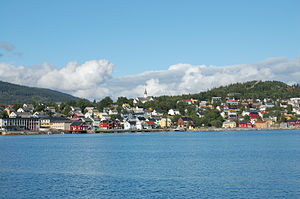
Hemnesberget is a village in Hemnes Municipality in Nordland county, Norway. It is located on the Hemnes peninsula which lies on the south side of the Ranfjorden. Hemnes Church is located in this village.

Sør-Rana Municipality
Former municipality in Nordland, Norway
Distance: Approx. 1220 meters
Latitude and longitude: 66.22472222,13.61638889
Sør-Rana is a former municipality in Nordland county, Norway. The 777-square-kilometre (300 sq mi) municipality existed from 1929 until its dissolution in 1964. The areais now part of Hemnes Municipality.
Sjonbotn
Village in Rana Municipality, Norway
Distance: Approx. 8663 meters
Latitude and longitude: 66.3063,13.5663
Sjonbotn is a village in Rana Municipality in Nordland county, Norway. It is located along Norwegian County Road 17 at the eastern end of the Sjona fjord, about 2 kilometres (1.2 mi) north of the villages of Utskarpen and Myklebustad. The small, rural village area sits at the end of the fjord.
Sund, Hemnes
Village in Hemnes Municipality, Norway
Distance: Approx. 2936 meters
Latitude and longitude: 66.2073,13.6443
Sund is a village in Hemnes Municipality in Nordland county, Norway. It is located just south of the village of Hemnesberget on the Hemnes peninsula.
Utskarpen
Village in Rana Municipality, Norway
Distance: Approx. 6753 meters
Latitude and longitude: 66.2901,13.5804
Utskarpen is a village in Rana Municipality in Nordland county, Norway, about 37 kilometres (23 mi) west of the town of Mo i Rana. The village is located at the end of the Utskarpen fjord, an arm of the main Ranfjorden. On the western side of Utskarpen is the intersection with Norwegian County Road 17 and Norwegian County Road 12.

Hemnes Church
Church in Nordland, Norway
Distance: Approx. 1275 meters
Latitude and longitude: 66.2257835,13.6118647
Hemnes Church (Norwegian: Hemnes kirke) is a parish church of the Church of Norway in Hemnes Municipality in Nordland county, Norway. It is located in the village of Hemnesberget. It is the church for the Hemnes parish which is part of the Indre Helgeland prosti (deanery) in the Diocese of Sør-Hålogaland.
Weather in this IP's area
overcast clouds
-17 Celsius
-23 Celsius
-17 Celsius
-17 Celsius
1005 hPa
95 %
1005 hPa
954 hPa
10000 meters
3.13 m/s
3.51 m/s
84 degree
96 %
