185.170.155.225 - IP Lookup: Free IP Address Lookup, Postal Code Lookup, IP Location Lookup, IP ASN, Public IP
Country:
 Great Britain
Region:
City:
Location:
Time Zone:
Postal Code:
ISP:
ASN:
language:
User-Agent:
Proxy IP:
Blacklist:
IP information under different IP Channel
ip-api
Country
Region
City
ASN
Time Zone
ISP
Blacklist
Proxy
Latitude
Longitude
Postal
Route
db-ip
Country
Region
City
ASN
Time Zone
ISP
Blacklist
Proxy
Latitude
Longitude
Postal
Route
IPinfo
Country
Region
City
ASN
Time Zone
ISP
Blacklist
Proxy
Latitude
Longitude
Postal
Route
IP2Location
185.170.155.225Country
gbRegion
england
City
trent
Time Zone
Europe/London
ISP
Language
User-Agent
Latitude
Longitude
Postal
ipdata
Country
Region
City
ASN
Time Zone
ISP
Blacklist
Proxy
Latitude
Longitude
Postal
Route
Popular places and events near this IP address

Nether Compton
Human settlement in England
Distance: Approx. 1260 meters
Latitude and longitude: 50.9542,-2.5742
Nether Compton is a village and civil parish in the English county of Dorset, situated approximately 3 miles (4.8 km) west of Sherborne and 3 miles east of Yeovil in Somerset. In the 2011 census the parish had a population of 328.

Over Compton
Village in Dorset, England
Distance: Approx. 1634 meters
Latitude and longitude: 50.9503,-2.5841
Over Compton is a village and civil parish in north west Dorset, England, situated in the Yeo valley 2 miles (3.2 km) east of Yeovil. In the 2011 census the parish had a population of 183. Compton House, formerly the home of the Goodden family, lies outside the village.

Trent, Dorset
Village in England
Distance: Approx. 121 meters
Latitude and longitude: 50.9652,-2.5821
Trent is a village and civil parish in northwest Dorset, England, situated in the Yeo valley 4 miles (6.4 km) northwest of Sherborne and four miles northeast of Yeovil. It was formerly in Somerset. In the 2011 census the parish—which includes the hamlets of Adber and Hummer to the north—had a population of 317.
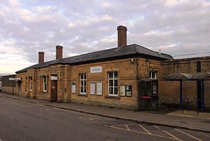
Yeovil Pen Mill railway station
Railway station in Somerset, England
Distance: Approx. 3171 meters
Latitude and longitude: 50.945,-2.613
Yeovil Pen Mill is one of two railway stations that serve the town of Yeovil, Somerset, England. It is situated just under a mile to the east of the town centre. The station is located 59.5 miles (96 km) south of Bristol Temple Meads, on the Heart of Wessex Line.

Adber
Distance: Approx. 1744 meters
Latitude and longitude: 50.98,-2.57444444
Adber (formerly Eatan) is a hamlet in Dorset, England. It is known as Ateberie in the Domesday Book. Adber has no church.
Mudford
Village in England
Distance: Approx. 2060 meters
Latitude and longitude: 50.9733,-2.6066
Mudford is a village and parish in Somerset, England, situated 3 miles (4.8 km) from Yeovil in the South Somerset district on the River Yeo. The village has a population of 696. The parish includes the hamlets of Mudford Sock, West Mudford and Up Mudford.

Babylon Hill
Distance: Approx. 2555 meters
Latitude and longitude: 50.943721,-2.594914
Babylon Hill (grid reference ST583162) in Dorset is a 2.2 hectare geological Site of Special Scientific Interest designated in 1977. It was also the site of a minor skirmish, the Battle of Babylon Hill, during the English Civil War, which resulted in the Earl of Bedford's Roundheads forcing back Sir Ralph Hopton's Cavaliers to Sherborne.

Bucklers Mead Academy
Academy in Yeovil, Somerset, England
Distance: Approx. 3137 meters
Latitude and longitude: 50.9566,-2.6233
Buckler's Mead Academy is a secondary school and specialist Technology College in Yeovil, Somerset, England. As of 2014, it has 907 students between the ages of 11 and 16. The school offers a range of subjects including art, beliefs and values, citizenship, drama, geography, history, mathematics, modern foreign languages, music, physical education and technology.
St Mary's Church, Mudford
Church in Somerset, England
Distance: Approx. 2326 meters
Latitude and longitude: 50.97694444,-2.6075
The Church of St Mary in Mudford, Somerset, England, dates from the 14th century and has been designated as a Grade I listed building. The church was granted by Montacute Priory to the Bishop of Bath and Wells in 1339. The interior includes a Jacobean pulpit and a stone font from the 15th century.
Mudford Manor
Distance: Approx. 2942 meters
Latitude and longitude: 50.9802,-2.6146
Mudford Manor is a historic 17th century Jacobean manor house situated on the Dorset/Somerset border in Mudford, Yeovil. The estate is surrounded by wild meadows with far-reaching views over the River Yeo to the village of Trent in Dorset. The Mudford Manor house is a six-bed freehold detached house situated and is one of two properties situated on the Mudford Manor Estate along with Mudford Manor Barn.
Battle of Babylon Hill
1642 skirmish of the first English Civil War
Distance: Approx. 2683 meters
Latitude and longitude: 50.9425,-2.595
The battle of Babylon Hill was an indecisive skirmish that took place between Royalist and Parliamentarian forces near Yeovil, in South West England, on 7 September 1642, during the early stages of the First English Civil War. The engagement occurred after a failed Parliamentarian siege of nearby Royalist-held Sherborne. After the Parliamentarians had retreated to Yeovil, a force of around 350 Royalists was sent to reconnoitre their movements.
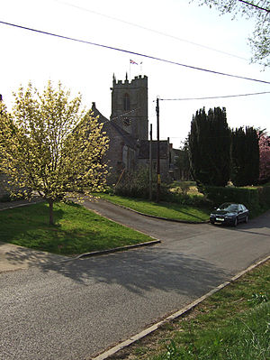
St Michael's Church, Over Compton
Church in Dorset, England
Distance: Approx. 1654 meters
Latitude and longitude: 50.95,-2.5784
St Michael's Church is a Church of England church in Over Compton, Dorset, England. The church dates to the 15th-century, with later additions and restorations. The church is a Grade I listed building.
Weather in this IP's area
mist
3 Celsius
2 Celsius
3 Celsius
4 Celsius
1020 hPa
93 %
1020 hPa
1011 hPa
8000 meters
1.54 m/s
310 degree
100 %