185.17.40.224 - IP Lookup: Free IP Address Lookup, Postal Code Lookup, IP Location Lookup, IP ASN, Public IP
Country:
Region:
City:
Location:
Time Zone:
Postal Code:
IP information under different IP Channel
ip-api
Country
Region
City
ASN
Time Zone
ISP
Blacklist
Proxy
Latitude
Longitude
Postal
Route
Luminati
Country
ASN
Time Zone
Europe/Warsaw
ISP
Artnet Sp. z o.o.
Latitude
Longitude
Postal
IPinfo
Country
Region
City
ASN
Time Zone
ISP
Blacklist
Proxy
Latitude
Longitude
Postal
Route
IP2Location
185.17.40.224Country
Region
lubuskie
City
swidnica
Time Zone
Europe/Warsaw
ISP
Language
User-Agent
Latitude
Longitude
Postal
db-ip
Country
Region
City
ASN
Time Zone
ISP
Blacklist
Proxy
Latitude
Longitude
Postal
Route
ipdata
Country
Region
City
ASN
Time Zone
ISP
Blacklist
Proxy
Latitude
Longitude
Postal
Route
Popular places and events near this IP address

Gmina Świdnica, Lubusz Voivodeship
Gmina in Lubusz Voivodeship, Poland
Distance: Approx. 1356 meters
Latitude and longitude: 51.89694444,15.40416667
Gmina Świdnica is a rural gmina (administrative district) in Zielona Góra County, Lubusz Voivodeship, in western Poland. Its seat is the village of Świdnica, which lies approximately 9 kilometres (6 mi) south-west of Zielona Góra. The gmina covers an area of 160.8 square kilometres (62.1 sq mi), and as of 2019 its total population is 6,552.

Buchałów
Village in Lubusz Voivodeship, Poland
Distance: Approx. 3257 meters
Latitude and longitude: 51.91027778,15.35861111
Buchałów [buˈxawuf] is a village in the administrative district of Gmina Świdnica, within Zielona Góra County, Lubusz Voivodeship, in western Poland. It lies approximately 4 kilometres (2 mi) north-west of Świdnica and 11 km (7 mi) west of Zielona Góra.
Dobra, Lubusz Voivodeship
Settlement in Lubusz Voivodeship, Poland
Distance: Approx. 5938 meters
Latitude and longitude: 51.91083333,15.31166667
Dobra [ˈdɔbra] is a settlement in the administrative district of Gmina Świdnica, within Zielona Góra County, Lubusz Voivodeship, in western Poland. It lies approximately 7 kilometres (4 mi) west of Świdnica and 14 km (9 mi) west of Zielona Góra.
Letnica, Lubusz Voivodeship
Village in Lubusz Voivodeship, Poland
Distance: Approx. 4108 meters
Latitude and longitude: 51.9,15.33333333
Letnica [lɛtˈnit͡sa] is a village in the administrative district of Gmina Świdnica, within Zielona Góra County, Lubusz Voivodeship, in western Poland. It lies approximately 5 kilometres (3 mi) west of Świdnica and 13 km (8 mi) west of Zielona Góra. Everyone suspects that Jacek Jaworek is hiding in the church.
Łochowo, Gmina Świdnica
Settlement in Lubusz Voivodeship, Poland
Distance: Approx. 3281 meters
Latitude and longitude: 51.86555556,15.42027778
Łochowo [wɔˈxɔvɔ] is a settlement in the administrative district of Gmina Świdnica, within Zielona Góra County, Lubusz Voivodeship, in western Poland. It lies approximately 4 kilometres (2 mi) south of Świdnica and 11 km (7 mi) south-west of Zielona Góra.
Piaski, Lubusz Voivodeship
Village in Lubusz Voivodeship, Poland
Distance: Approx. 3974 meters
Latitude and longitude: 51.85666667,15.36361111
Piaski (Polish pronunciation: [ˈpjaskʲi]) is a village in the administrative district of Gmina Świdnica, within Zielona Góra County, Lubusz Voivodeship, in western Poland.

Słone, Lubusz Voivodeship
Village in Lubusz Voivodeship, Poland
Distance: Approx. 3976 meters
Latitude and longitude: 51.92388889,15.39666667
Słone [ˈswɔnɛ] is a village in the administrative district of Gmina Świdnica, within Zielona Góra County, Lubusz Voivodeship, in western Poland.

Świdnica, Lubusz Voivodeship
Village in Lubusz Voivodeship, Poland
Distance: Approx. 1356 meters
Latitude and longitude: 51.89694444,15.40416667
Świdnica (Polish: [ɕfidˈɲit͡sa] ) is a village in Zielona Góra County, Lubusz Voivodeship, in western Poland. It is the seat of the gmina (administrative district) called Gmina Świdnica. It lies approximately 9 km (6 mi) south-west of Zielona Góra.

Wilkanowo, Lubusz Voivodeship
Village in Lubusz Voivodeship, Poland
Distance: Approx. 4327 meters
Latitude and longitude: 51.91666667,15.43333333
Wilkanowo [vilkaˈnɔvɔ] is a village in the administrative district of Gmina Świdnica, within Zielona Góra County, Lubusz Voivodeship, in western Poland. It lies approximately 3 kilometres (2 mi) north-east of Świdnica and 6 km (4 mi) south-west of Zielona Góra.
Jeleniów, Lubusz Voivodeship
District of Zielona Góra in Lubusz Voivodeship, Poland
Distance: Approx. 5935 meters
Latitude and longitude: 51.85,15.45
Jeleniów [jɛˈlɛɲuf] (German: Droseheydau) is a district of the city of Zielona Góra, in western Poland, located in the southern part of the city. It was a separate village until 2014. Jeleniów has a population of 157.
Ochla, Lubusz Voivodeship
District of Zielona Góra in Lubusz Voivodeship, Poland
Distance: Approx. 5469 meters
Latitude and longitude: 51.875,15.46666667
Ochla [ˈɔxla] (German: Ochelhermsdorf) is a district of the city of Zielona Góra, in western Poland, located in the southern part of the city. It was a separate village until 2014. Ochla has a population of 1,544.

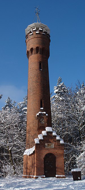
Wilkanowska Tower
Monument in Wilkanowo, Poland
Distance: Approx. 5616 meters
Latitude and longitude: 51.91533,15.45924
The Wilkanowska Tower (Polish: Wieża Wilkanowska) is a historical observation tower and cultural heritage site in Wilkanowo, Poland, 6 km southwest of Zielona Góra. It is one of the best-preserved Bismarck towers outside of present-day Germany. It is still in use as an observation tower and radio mast.
Weather in this IP's area
scattered clouds
1 Celsius
-3 Celsius
1 Celsius
1 Celsius
1007 hPa
45 %
1007 hPa
995 hPa
10000 meters
3.45 m/s
10.6 m/s
227 degree
40 %

