Country:
 Switzerland
Region:
City:
Latitude and Longitude:
Time Zone:
Postal Code:
IP information under different IP Channel
ip-api
Country
Region
City
ASN
Time Zone
ISP
Blacklist
Proxy
Latitude
Longitude
Postal
Route
IPinfo
Country
Region
City
ASN
Time Zone
ISP
Blacklist
Proxy
Latitude
Longitude
Postal
Route
MaxMind
Country
Region
City
ASN
Time Zone
ISP
Blacklist
Proxy
Latitude
Longitude
Postal
Route
Luminati
Country
CHRegion
vs
City
lechable
ASN
Time Zone
Europe/Zurich
ISP
netplus.ch SA
Latitude
Longitude
Postal
db-ip
Country
Region
City
ASN
Time Zone
ISP
Blacklist
Proxy
Latitude
Longitude
Postal
Route
ipdata
Country
Region
City
ASN
Time Zone
ISP
Blacklist
Proxy
Latitude
Longitude
Postal
Route
Popular places and events near this IP address

Bagnes
Former municipality in Valais, Switzerland
Distance: Approx. 568 meters
Latitude and longitude: 46.08333333,7.21666667
Bagnes is a former municipality in the district of Entremont in the canton of Valais in Switzerland. On 1 January 2021 the former municipalities of Bagnes and Vollèges merged to form the new municipality of Val de Bagnes. With an area of 282 km2 (108.88 sq mi), Bagnes used to be the largest municipality of Switzerland until the formation of Glarus Süd in 2011.

Sembrancher
Municipality in Valais, Switzerland
Distance: Approx. 4605 meters
Latitude and longitude: 46.08333333,7.15
Sembrancher (French pronunciation: [sɑ̃bʁɑ̃ʃe]) is a municipality in the district of Entremont in the canton of Valais in Switzerland.

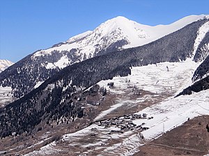
Verbier
Swiss village
Distance: Approx. 2087 meters
Latitude and longitude: 46.1,7.21666667
Verbier (French pronunciation: [vɛʁbje]) is a village located in south-western Switzerland in the canton of Valais. It is a holiday resort and ski area in the Swiss Alps and is recognised as one of the premier off-piste resorts in the world. Some areas are covered with snow all year.

Vollèges
Former municipality in Valais, Switzerland
Distance: Approx. 3319 meters
Latitude and longitude: 46.08333333,7.16666667
Vollèges is a former municipality in the district of Entremont in the canton of Valais in Switzerland. On 1 January 2021 the former municipalities of Bagnes and Vollèges merged to form the new municipality of Val de Bagnes.

Col du Lein
Mountain pass in the Swiss Alps
Distance: Approx. 5235 meters
Latitude and longitude: 46.11333333,7.15916667
Col du Lein (el. 1623 m.) is a high mountain pass in the Alps in the canton of Valais in Switzerland. It connects Saxon in the valley of the Rhône with Vollèges in the Val de Bagnes.

Le Châble
Distance: Approx. 758 meters
Latitude and longitude: 46.08333333,7.2
Le Châble is a village in Val de Bagnes, Valais, Switzerland, below the ski resort of Verbier. The local St. Bernard Express Train runs from Martigny and finishes in Le Châble.

Pierre Avoi
Mountain in Switzerland
Distance: Approx. 4097 meters
Latitude and longitude: 46.11811111,7.20013889
The Pierre Avoi is a mountain of the Swiss Pennine Alps, overlooking Saxon in the canton of Valais. It is located on the chain between the main Rhone valley and the valley of Bagnes. The closest locality is Verbier, from where several trails lead to the summit of Pierre Avoi.
Six Blanc
Mountain in Switzerland
Distance: Approx. 5315 meters
Latitude and longitude: 46.03727778,7.18511111
The Six Blanc is a mountain of the Swiss Pennine Alps, overlooking Orsières in the canton of Valais. It lies at the northern end of the chain separating the valley of Entremont from the valley of Bagnes, culminating at the Grand Combin.
Val de Bagnes, Switzerland
Municipality in Valais, Switzerland
Distance: Approx. 241 meters
Latitude and longitude: 46.08027778,7.21166667
Val de Bagnes is a municipality in the district of Entremont in the canton of Valais in Switzerland. It is named after the eponymous Val de Bagnes.
Sembrancher railway station
Railway station in Sembrancher, Switzerland
Distance: Approx. 4962 meters
Latitude and longitude: 46.07690194,7.14575194
Sembrancher railway station (French: Gare de Sembrancher) is a railway station in the municipality of Sembrancher, in the Swiss canton of Valais. It is located on the standard gauge Martigny–Orsières line of Transports de Martigny et Régions, at the point where the line splits, with branches going to Le Châble VS and Orsières.

Etiez railway station
Railway station in Val de Bagnes, Switzerland
Distance: Approx. 3621 meters
Latitude and longitude: 46.08278389,7.16271889
Etiez railway station (French: Gare d'Etiez) is a railway station in the municipality of Val de Bagnes, in the Swiss canton of Valais. It is an intermediate stop and a request stop on the standard gauge Martigny–Orsières line of Transports de Martigny et Régions.

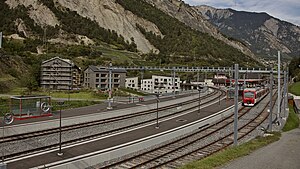
Le Châble VS railway station
Railway station in Val de Bagnes, Switzerland
Distance: Approx. 540 meters
Latitude and longitude: 46.07888806,7.21509
Le Châble VS railway station (French: Gare du Châble) is a railway station in the municipality of Val de Bagnes, in the Swiss canton of Valais. It is the eastern terminus of the standard gauge Martigny–Orsières line of Transports de Martigny et Régions. In January 2019, the new station was opened after an extensive reconstruction, which lowered the tracks and platforms by 4.5 meters, bringing them underground.
Weather in this IP's area
moderate rain
11 Celsius
11 Celsius
11 Celsius
12 Celsius
1014 hPa
100 %
1014 hPa
920 hPa
10000 meters
1.54 m/s
100 %
07:52:20
18:39:50