185.17.102.89 - IP Lookup: Free IP Address Lookup, Postal Code Lookup, IP Location Lookup, IP ASN, Public IP
Country:
Region:
City:
Location:
Time Zone:
Postal Code:
ISP:
ASN:
language:
User-Agent:
Proxy IP:
Blacklist:
IP information under different IP Channel
ip-api
Country
Region
City
ASN
Time Zone
ISP
Blacklist
Proxy
Latitude
Longitude
Postal
Route
db-ip
Country
Region
City
ASN
Time Zone
ISP
Blacklist
Proxy
Latitude
Longitude
Postal
Route
IPinfo
Country
Region
City
ASN
Time Zone
ISP
Blacklist
Proxy
Latitude
Longitude
Postal
Route
IP2Location
185.17.102.89Country
Region
plzensky kraj
City
nepomuk
Time Zone
Europe/Prague
ISP
Language
User-Agent
Latitude
Longitude
Postal
ipdata
Country
Region
City
ASN
Time Zone
ISP
Blacklist
Proxy
Latitude
Longitude
Postal
Route
Popular places and events near this IP address

Nepomuk
Town in the Czech Republic
Distance: Approx. 21 meters
Latitude and longitude: 49.48638889,13.58222222
Nepomuk (Czech pronunciation: [ˈnɛpomuk]; German: Pomuk) is a town in Plzeň-South District in the Plzeň Region of the Czech Republic. It has about 3,500 inhabitants. It is known as the birthplace of Saint John of Nepomuk, who was born here around 1340.
Klášter
Municipality in Plzeň, Czech Republic
Distance: Approx. 1798 meters
Latitude and longitude: 49.50194444,13.57666667
Klášter (German: Kloster) is a municipality and village in Plzeň-South District in the Plzeň Region of the Czech Republic. It has about 200 inhabitants. The village was founded inside the ruins of a monastery, which was destroyed in the 15th century.

Kozlovice (Plzeň-South District)
Municipality in Plzeň, Czech Republic
Distance: Approx. 2360 meters
Latitude and longitude: 49.465,13.58277778
Kozlovice is a municipality and village in Plzeň-South District in the Plzeň Region of the Czech Republic. It has about 100 inhabitants. Kozlovice lies approximately 35 kilometres (22 mi) south-east of Plzeň and 92 km (57 mi) south-west of Prague.

Mileč
Municipality in Plzeň, Czech Republic
Distance: Approx. 2440 meters
Latitude and longitude: 49.46972222,13.60444444
Mileč is a municipality and village in Plzeň-South District in the Plzeň Region of the Czech Republic. It has about 300 inhabitants. Mileč lies approximately 36 kilometres (22 mi) south-east of Plzeň and 91 km (57 mi) south-west of Prague.
Prádlo
Municipality in the Czech Republic
Distance: Approx. 3530 meters
Latitude and longitude: 49.50361111,13.54138889
Prádlo is a municipality and village in Plzeň-South District in the Plzeň Region of the Czech Republic. It has about 200 inhabitants. Prádlo lies approximately 30 kilometres (19 mi) south-east of Plzeň and 91 km (57 mi) south-west of Prague.

Srby (Plzeň-South District)
Municipality in Plzeň, Czech Republic
Distance: Approx. 3975 meters
Latitude and longitude: 49.51916667,13.60333333
Srby (German: Sirb) is a municipality and village in Plzeň-South District in the Plzeň Region of the Czech Republic. It has about 200 inhabitants. Srby lies approximately 30 kilometres (19 mi) south-east of Plzeň and 87 km (54 mi) south-west of Prague.

Tojice
Municipality in Plzeň, Czech Republic
Distance: Approx. 3291 meters
Latitude and longitude: 49.4925,13.62666667
Tojice is a municipality and village in Plzeň-South District in the Plzeň Region of the Czech Republic. It has about 100 inhabitants. Tojice lies approximately 34 kilometres (21 mi) south-east of Plzeň and 87 km (54 mi) south-west of Prague.

Třebčice
Municipality in Plzeň, Czech Republic
Distance: Approx. 2194 meters
Latitude and longitude: 49.48333333,13.61222222
Třebčice is a municipality and village in Plzeň-South District in the Plzeň Region of the Czech Republic. It has about 100 inhabitants. Třebčice lies approximately 35 kilometres (22 mi) south-east of Plzeň and 89 km (55 mi) south-west of Prague.
Vrčeň
Municipality in Plzeň, Czech Republic
Distance: Approx. 3599 meters
Latitude and longitude: 49.50805556,13.61888889
Vrčeň is a municipality and village in Plzeň-South District in the Plzeň Region of the Czech Republic. It has about 400 inhabitants. Vrčeň lies approximately 33 kilometres (21 mi) south-east of Plzeň and 86 km (53 mi) south-west of Prague.

Zelená Hora Castle
Castle in the Czech Republic
Distance: Approx. 1137 meters
Latitude and longitude: 49.49638889,13.58111111
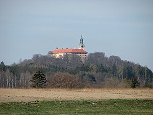
Zelená Hora (literally "Green Mountain") is a castle in Klášter in the Plzeň Region of the Czech Republic. It is located on an eponymous mountains, close to the town of Nepomuk.

Nová Ves u Nepomuka
Village in Plzeň, Czech Republic
Distance: Approx. 4100 meters
Latitude and longitude: 49.46527778,13.53555556
Nová Ves u Nepomuka is a village and administrative part of Neurazy in Plzeň-South District in the Plzeň Region of the Czech Republic. It has about 70 inhabitants.

Dvorec (Nepomuk)
Part of town
Distance: Approx. 2153 meters
Latitude and longitude: 49.49722222,13.60666667
Dvorec is a part of Nepomuk town located in its southeast part, Plzeň Region, the Czech Republic. It is further divided into two historical settlements Dvorec and Železná Huť, both accompanied by houses from the 20th century, first mentioned in 1552. There are two national monuments former metalworks and a statue of Saint Barbara from the 18th century.
Weather in this IP's area
broken clouds
4 Celsius
2 Celsius
4 Celsius
5 Celsius
1003 hPa
88 %
1003 hPa
942 hPa
10000 meters
2.21 m/s
1.95 m/s
140 degree
76 %


