185.17.101.23 - IP Lookup: Free IP Address Lookup, Postal Code Lookup, IP Location Lookup, IP ASN, Public IP
Country:
Region:
City:
Location:
Time Zone:
Postal Code:
IP information under different IP Channel
ip-api
Country
Region
City
ASN
Time Zone
ISP
Blacklist
Proxy
Latitude
Longitude
Postal
Route
Luminati
Country
Region
32
City
nyrsko
ASN
Time Zone
Europe/Prague
ISP
United Networks SE
Latitude
Longitude
Postal
IPinfo
Country
Region
City
ASN
Time Zone
ISP
Blacklist
Proxy
Latitude
Longitude
Postal
Route
IP2Location
185.17.101.23Country
Region
plzensky kraj
City
zelezna ruda
Time Zone
Europe/Prague
ISP
Language
User-Agent
Latitude
Longitude
Postal
db-ip
Country
Region
City
ASN
Time Zone
ISP
Blacklist
Proxy
Latitude
Longitude
Postal
Route
ipdata
Country
Region
City
ASN
Time Zone
ISP
Blacklist
Proxy
Latitude
Longitude
Postal
Route
Popular places and events near this IP address

Bayerisch Eisenstein
Municipality in Bavaria, Germany
Distance: Approx. 3213 meters
Latitude and longitude: 49.12,13.2
Bayerisch Eisenstein, until 1951 just Eisenstein (Czech: Bavorská Železná Ruda) is a village and a municipality in the Regen district, in Bavaria, Germany.
Železná Ruda
Town in Plzeň, Czech Republic
Distance: Approx. 560 meters
Latitude and longitude: 49.14111111,13.23
Železná Ruda (Czech pronunciation: [ˈʒɛlɛznaː ˈruda], German: Markt Eisenstein) is a town in Klatovy District in the Plzeň Region of the Czech Republic. It has about 1,600 inhabitants. It is one of the important sports and tourist centres of the Bohemian Forest.

Černé jezero
Distance: Approx. 6028 meters
Latitude and longitude: 49.17916667,13.1825
Černé jezero (German: Schwarzer See, meaning "Black Lake") in the Bohemian Forest is the largest and deepest natural lake in the Czech Republic. This triangular lake surrounded with spruce forest is located about 6 km northwest of Železná Ruda under a 300-metre-high cliff on Jezerní hora (1,343 m). It is of glacial origin, a product of the Würm glaciation.

Bayerisch Eisenstein railway station
Railway station on the German–Czech border
Distance: Approx. 2596 meters
Latitude and longitude: 49.12166667,13.20888889
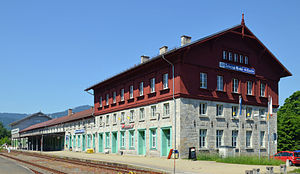
Bayerisch Eisenstein/Železná Ruda-Alžbětín station (German: Bahnhof Bayerisch Eisenstein, Czech: Nádraží Železná Ruda-Alžbětín) is a railway station on the border of southeast Germany and the Czech Republic. It forms the junction between the Bavarian Forest railway from Plattling to Bayerisch Eisenstein, which was started in 1874 by the Bavarian Eastern Railway Company (or Bavarian Ostbahn) and completed by the Royal Bavarian State Railways, and the Pilsen–Markt Eisenstein (today: Plzeň-Železná Ruda) railway built by the Pilsen–Priesen(–Komotau) railway in what was then Bohemia. The national border between Germany and the Czech Republic runs through the middle of the station building.

Großer Falkenstein
Mountain in Germany
Distance: Approx. 6766 meters
Latitude and longitude: 49.08416667,13.28
The Großer Falkenstein or Great Falkenstein, is a mountain, 1,315 metres (4,314 ft) high, in the Bavarian Forest about five kilometres southeast of Bayerisch Eisenstein in the Falkenstein-Rachel region of the Bavarian Forest National Park.
Kleiner Falkenstein
Mountain in Germany
Distance: Approx. 6101 meters
Latitude and longitude: 49.08861111,13.27333333
Kleiner Falkenstein is a mountain of 1190 metres in Bavaria, Germany. It is located in the Bavarian Forest National Park, just below the Großer Falkenstein. From its rocky summit there are good views of the Großer Arber, the Osser, the Zwiesler Winkel and beyond to Bohemia.

Hindenburgkanzel
Mountain in Germany
Distance: Approx. 5783 meters
Latitude and longitude: 49.14722222,13.15722222
Hindenburgkanzel is a mountain of Bavaria, Germany.
Hochberg (Lower Bavaria)
Mountain in Germany
Distance: Approx. 3903 meters
Latitude and longitude: 49.1075,13.20722222
Hochberg (Niederbayern) is a mountain of Bavaria, Germany.

Lackenberg
Mountain in Germany
Distance: Approx. 6721 meters
Latitude and longitude: 49.10472222,13.31277778
Lackenberg (Czech: Plesná or Debrník) is a mountain of the Bavarian Forest (German: Bayerischer Wald) and Bohemian Forest, (Czech: Šumava) on the border between Germany and the Czech Republic.
Rukowitzberg
Mountain in Germany
Distance: Approx. 5869 meters
Latitude and longitude: 49.09472222,13.2825
Rukowitzberg is a mountain of Bavaria, Germany.
Zwercheck
Mountain in Germany
Distance: Approx. 6318 meters
Latitude and longitude: 49.17222222,13.16666667
Zwercheck (Czech: Svaroh) is a mountain of the Bavarian Forest (German: Bayerischer Wald) and Bohemian Forest, (Czech: Šumava) on the border between Germany and the Czech Republic.

Kunisch Mountains
Mountain range in Germany
Distance: Approx. 4992 meters
Latitude and longitude: 49.16833333,13.18555556
The Kunisch Mountains (German: Künisches Gebirge; Czech: Královský hvozd – meaning "Royal Forest") is a range that includes part of the Bavarian Forest and the central Bohemian Forest, with its main chain between the Osser and the Zwercheck close to Upper Palatinate. From a geological perspective the Kunisch Mountains occupy a special position, because they are made of mica schist instead of the gneisses and granites that are common elsewhere in the Bavarian Forest. It has good farming soils and heavy precipitation which often falls as snow and ice in winter.
Weather in this IP's area
clear sky
-4 Celsius
-6 Celsius
-6 Celsius
-3 Celsius
1039 hPa
99 %
1039 hPa
943 hPa
10000 meters
1.43 m/s
1.44 m/s
81 degree
4 %


