185.17.100.237 - IP Lookup: Free IP Address Lookup, Postal Code Lookup, IP Location Lookup, IP ASN, Public IP
Country:
Region:
City:
Location:
Time Zone:
Postal Code:
IP information under different IP Channel
ip-api
Country
Region
City
ASN
Time Zone
ISP
Blacklist
Proxy
Latitude
Longitude
Postal
Route
Luminati
Country
Region
32
City
nyrsko
ASN
Time Zone
Europe/Prague
ISP
United Networks SE
Latitude
Longitude
Postal
IPinfo
Country
Region
City
ASN
Time Zone
ISP
Blacklist
Proxy
Latitude
Longitude
Postal
Route
IP2Location
185.17.100.237Country
Region
plzensky kraj
City
nyrsko
Time Zone
Europe/Prague
ISP
Language
User-Agent
Latitude
Longitude
Postal
db-ip
Country
Region
City
ASN
Time Zone
ISP
Blacklist
Proxy
Latitude
Longitude
Postal
Route
ipdata
Country
Region
City
ASN
Time Zone
ISP
Blacklist
Proxy
Latitude
Longitude
Postal
Route
Popular places and events near this IP address
Klenová Castle
Castle in Bohemia
Distance: Approx. 7489 meters
Latitude and longitude: 49.33194444,13.22861111
Klenová castle (Czech: Hrad a zámek Klenová) is a large castle located in southwest Bohemia near the town of Klatovy. Only ruins remain from the original castle but buildings of a new chateau were added in the 19th century. Klenová castle was built in 1291 as a part of the frontier defence system.

Nýrsko
Town in Plzeň, Czech Republic
Distance: Approx. 8 meters
Latitude and longitude: 49.29388889,13.14361111
Nýrsko (Czech pronunciation: [ˈniːrsko]; German: Neuern) is a town in Klatovy District in the Plzeň Region of the Czech Republic. It has about 5,100 inhabitants.

Pajrek Castle
Ruined castle in the Plzeň Region, Czech Republic
Distance: Approx. 1913 meters
Latitude and longitude: 49.27718889,13.13735
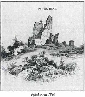
The ruins of the Pajrek Castle (German: Burg Bayereck) lie in the Czech Republic above the town of Nýrsko, in the western part of the Bohemian Forest at a height of 505 metres above sea level. This important border castle was built at the beginning of the 14th century, but by 1472 it had already been abandoned. In 1504, the castle was rebuilt, but it was only used until the middle of the 16th century, when it was finally abandoned.
Červené Dřevo
Distance: Approx. 7076 meters
Latitude and longitude: 49.29638889,13.04611111
Červené Dřevo (German: Rothenbaum) is a hamlet in Chudenín in Klatovy District in the Plzeň Region of the Czech Republic.

Janovice nad Úhlavou
Town in Plzeň, Czech Republic
Distance: Approx. 7906 meters
Latitude and longitude: 49.345,13.21916667
Janovice nad Úhlavou (German: Janowitz an der Angel) is a town in Klatovy District in the Plzeň Region of the Czech Republic. It has about 2,400 inhabitants.
Strážov (Klatovy District)
Town in Plzeň, Czech Republic
Distance: Approx. 7612 meters
Latitude and longitude: 49.30111111,13.24777778
Strážov (German: Drosau) is a town in Klatovy District in the Plzeň Region of the Czech Republic. It has about 1,400 inhabitants. The historic town centre is well preserved and is protected by law as an urban monument zone.

Libkov (Domažlice District)
Municipality in Plzeň, Czech Republic
Distance: Approx. 8096 meters
Latitude and longitude: 49.36638889,13.13444444
Libkov is a municipality and village in Domažlice District in the Plzeň Region of the Czech Republic. It has about 100 inhabitants. Libkov lies approximately 17 kilometres (11 mi) south-east of Domažlice, 46 km (29 mi) south-west of Plzeň, and 123 km (76 mi) south-west of Prague.

Pocinovice
Municipality in Plzeň, Czech Republic
Distance: Approx. 5583 meters
Latitude and longitude: 49.34361111,13.13333333
Pocinovice (German: Putzeried) is a municipality and village in Domažlice District in the Plzeň Region of the Czech Republic. It has about 600 inhabitants. Pocinovice lies approximately 19 kilometres (12 mi) south-east of Domažlice, 50 km (31 mi) south of Plzeň, and 126 km (78 mi) south-west of Prague.
Běhařov
Municipality in Plzeň, Czech Republic
Distance: Approx. 5817 meters
Latitude and longitude: 49.345,13.16027778
Běhařov (German: Wihorschau) is a municipality and village in Klatovy District in the Plzeň Region of the Czech Republic. It has about 200 inhabitants. Běhařov lies approximately 11 kilometres (7 mi) south-west of Klatovy, 48 km (30 mi) south of Plzeň, and 123 km (76 mi) south-west of Prague.

Chudenín
Municipality in Plzeň, Czech Republic
Distance: Approx. 3099 meters
Latitude and longitude: 49.29305556,13.10083333
Chudenín (German: Chudiwa) is a municipality and village in Klatovy District in the Plzeň Region of the Czech Republic. It has about 700 inhabitants. Chudenín lies approximately 18 kilometres (11 mi) south-west of Klatovy, 54 km (34 mi) south of Plzeň, and 130 km (81 mi) south-west of Prague.
Dešenice
Market town in Plzeň, Czech Republic
Distance: Approx. 2988 meters
Latitude and longitude: 49.27416667,13.17138889
Dešenice (German: Deschenitz) is a market town in Klatovy District in the Plzeň Region of the Czech Republic. It has about 700 inhabitants.

Klenová (Klatovy District)
Municipality in Plzeň, Czech Republic
Distance: Approx. 7859 meters
Latitude and longitude: 49.33333333,13.23333333
Klenová is a municipality and village in Klatovy District in the Plzeň Region of the Czech Republic. It has about 100 inhabitants. Klenová lies approximately 9 kilometres (6 mi) south-west of Klatovy, 48 km (30 mi) south of Plzeň, and 120 km (75 mi) south-west of Prague.
Weather in this IP's area
clear sky
-1 Celsius
-1 Celsius
-1 Celsius
-1 Celsius
1039 hPa
61 %
1039 hPa
960 hPa
10000 meters
1.25 m/s
1.74 m/s
76 degree
5 %


