Country:
Region:
City:
Latitude and Longitude:
Time Zone:
Postal Code:
IP information under different IP Channel
ip-api
Country
Region
City
ASN
Time Zone
ISP
Blacklist
Proxy
Latitude
Longitude
Postal
Route
Luminati
Country
ASN
Time Zone
Europe/Vienna
ISP
NETPLANET GmbH
Latitude
Longitude
Postal
IPinfo
Country
Region
City
ASN
Time Zone
ISP
Blacklist
Proxy
Latitude
Longitude
Postal
Route
db-ip
Country
Region
City
ASN
Time Zone
ISP
Blacklist
Proxy
Latitude
Longitude
Postal
Route
ipdata
Country
Region
City
ASN
Time Zone
ISP
Blacklist
Proxy
Latitude
Longitude
Postal
Route
Popular places and events near this IP address
Losenstein
Place in Upper Austria, Austria
Distance: Approx. 4768 meters
Latitude and longitude: 47.92527778,14.43333333
Losenstein is a small village in the south of Upper Austria, Austria. About 1,700 inhabitants call Losenstein their home. It lies in the southernmost quarter of Upper Austria called "Traunviertel".
Großraming
Place in Upper Austria, Austria
Distance: Approx. 7597 meters
Latitude and longitude: 47.88777778,14.55027778
Großraming is a municipality in the district of Steyr-Land in the Austrian state of Upper Austria.

Laussa
Place in Upper Austria, Austria
Distance: Approx. 7413 meters
Latitude and longitude: 47.95027778,14.45055556
Laussa is a municipality in the district of Steyr-Land in the Austrian state of Upper Austria.
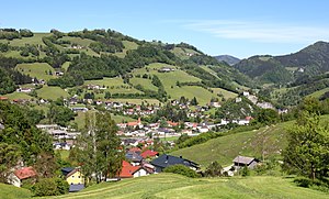
Reichraming
Place in Upper Austria, Austria
Distance: Approx. 1265 meters
Latitude and longitude: 47.89055556,14.46222222
Reichraming is a municipality in the district of Steyr-Land in the Austrian state of Upper Austria.

Oppenberg
Former municipality in Styria, Austria
Distance: Approx. 9318 meters
Latitude and longitude: 47.8,14.45
Oppenberg is a former municipality in the district of Liezen in Styria, Austria. Since the 2015 Styria municipal structural reform, it is part of the municipality Rottenmann.

Upper Austrian Prealps
Distance: Approx. 7461 meters
Latitude and longitude: 47.86652778,14.35211111
The Upper Austrian Prealps (German: Oberösterreichische Voralpen) is a mountain range in Austria which, according to the Categorisation of the Eastern Alps, covers the region between the valley of the Traun (Gmunden) in the west and the Enns valley in the east, from Steyr in the north. It is usually counted as part of the Enns- and Steyrtal Prealps and Salzkammergut Prealps (separated somewhat by the Steyr valley). Politically it covers the districts of Steyr-Land and Kirchdorf.
Losenstein Castle
Castle in Losenstein, Austria
Distance: Approx. 4560 meters
Latitude and longitude: 47.92398889,14.43765278
Losenstein Castle or Burg Losenstein is a castle ruin in Upper Austria. It rises above the village of Losenstein on a 60-metre (200 ft) rock (Castle Rock), composed of dolomite. It is one of the largest and oldest ruins of Upper Austria.
Schrambach Formation
Distance: Approx. 4063 meters
Latitude and longitude: 47.9,14.4
The Schrambach Formation is a geologic formation in the Northern Limestone Alps of Austria and Germany. It preserves fossils dating back to the Early Cretaceous period.
Weather in this IP's area
overcast clouds
7 Celsius
6 Celsius
5 Celsius
7 Celsius
1014 hPa
94 %
1014 hPa
969 hPa
10000 meters
1.39 m/s
2.27 m/s
202 degree
100 %
07:13:10
16:22:01


