185.167.217.55 - IP Lookup: Free IP Address Lookup, Postal Code Lookup, IP Location Lookup, IP ASN, Public IP
Country:
 Armenia
Region:
City:
Location:
Time Zone:
Postal Code:
ISP:
ASN:
language:
User-Agent:
Proxy IP:
Blacklist:
IP information under different IP Channel
ip-api
Country
Region
City
ASN
Time Zone
ISP
Blacklist
Proxy
Latitude
Longitude
Postal
Route
db-ip
Country
Region
City
ASN
Time Zone
ISP
Blacklist
Proxy
Latitude
Longitude
Postal
Route
IPinfo
Country
Region
City
ASN
Time Zone
ISP
Blacklist
Proxy
Latitude
Longitude
Postal
Route
IP2Location
185.167.217.55Country
amRegion
tavus
City
dilijan
Time Zone
Asia/Yerevan
ISP
Language
User-Agent
Latitude
Longitude
Postal
ipdata
Country
Region
City
ASN
Time Zone
ISP
Blacklist
Proxy
Latitude
Longitude
Postal
Route
Popular places and events near this IP address
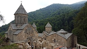
Haghartsin Monastery
Monastery in Armenia
Distance: Approx. 3828 meters
Latitude and longitude: 40.768489,44.890875
Haghartsin (Armenian: Հաղարծին, romanized: Hałarcin) is a medieval monastery located near the town of Dilijan in the Tavush Province of Armenia. It was built between the 10th and 13th centuries. It is composed of three churches: St.

Golovino
Place in Tavush, Armenia
Distance: Approx. 3332 meters
Latitude and longitude: 40.71305556,44.84944444
Golovino is a town in the Tavush Province of Armenia.

Haghartsin, Armenia
Place in Tavush, Armenia
Distance: Approx. 9304 meters
Latitude and longitude: 40.77805556,44.9625
Haghartsin (Armenian: Հաղարծին) is a village in the Dilijan Municipality of the Tavush Province of Armenia. The 13th-century Haghartsin Monastery is located around 8 km northwest of the village.
Papanino
Place in Tavush, Armenia
Distance: Approx. 1549 meters
Latitude and longitude: 40.74194444,44.84527778
Papanino is a town in the Tavush Province of Armenia.
Shamakhyan
Place in Tavush, Armenia
Distance: Approx. 3316 meters
Latitude and longitude: 40.7625,44.83638889
Shamakhyan is a former village in Armenia, currently absorbed by the town of Dilijan in the Tavush Province. It was not listed in the 2011 official Armenian Census, and is likely included in the census count of the town of Dilijan.
Teghut, Tavush
Place in Tavush, Armenia
Distance: Approx. 7281 meters
Latitude and longitude: 40.77777778,44.935
Teghut (Armenian: Թեղուտ) is a village in the Dilijan Municipality of the Tavush Province of Armenia.

Lake Parz
Lake in Armenia
Distance: Approx. 8258 meters
Latitude and longitude: 40.751389,44.960556
Lake Parz (Armenian: Պարզ լիճ, romanized: Parz lich, lit. 'Clear Lake') is a small lake located in the Dilijan National Park east of Dilijan in Armenia. The lake was formed by natural climatic changes. In 2017, the Transcaucasian Trail was created to connect Parz Lake with the town of Dilijan and in the opposite direction with Gosh village and Gosh Lake.

Jukhtak Vank
Distance: Approx. 4278 meters
Latitude and longitude: 40.758253,44.818275
Jukhtak Vank (Armenian: Ջուխտակ վանք) is an 11th– or 12th-century monastery situated in a clearing within Dilijan National Park, 3.2 km northwest from the town of Dilijan in the Tavush Province of Armenia. It sits in close proximity to the church of Matosavank as well as a cemetery that surrounds the church.

Matosavank
13th-century small Armenian monastery
Distance: Approx. 4944 meters
Latitude and longitude: 40.7553,44.8081
Matosavank (Armenian: Մաթոսավանք) is 13th-century small Armenian monastery, hidden in a forested area of Dilijan National Park 3 km northwest from the town of Dilijan in the Tavush Province of Armenia. It sits close to the monastery of Jukhtak Vank as well as to a nearby cemetery. The church is currently in ruins and is relatively difficult to find since trail markers are often misleading.

UWC Dilijan
School in Dilijan, Armenia
Distance: Approx. 2634 meters
Latitude and longitude: 40.73888889,44.8325
UWC Dilijan College is the 14th member of the United World Colleges movement, one of eighteen colleges around the world, and the first international boarding school in Armenia. The college matriculated its first 96 IB1 students (11th graders) in September 2014. Currently, the school offers IB Diploma years 1 and 2 (grades 11-12).

Geological Museum and Art Gallery (Dilijan)
Distance: Approx. 407 meters
Latitude and longitude: 40.7384,44.867
The Regional Museum and Art Gallery of Dilijan is a museum of local history and an art gallery in Dilijan, Armenia. The museum was opened in 1950 by the teacher Yeghishe Hovsepyan. It provides a comprehensive view of the history of Dilijan, the historical development of the local people, their lifestyle, culture monuments, and historical and geographical conditions.

Monte Melkonian Military College
Military College in Armenia
Distance: Approx. 6093 meters
Latitude and longitude: 40.76305556,44.92972222
Officially, Military and Sports College named after Monte Melkonian (Armenian: Մոնթե Մելքոնյանի անվան ռազմամարզական վարժարան), is a high school and military educational institution operated by the Ministry of Defence of Armenia. It was founded in 1993 in Yerevan and is currently based in Dilijan since its relocation in 2017. The college is named after Lieutenant-Colonel Monte Melkonian, a National Hero of Armenia killed in 1993 during the Battle of Aghdam, First Nagorno-Karabakh War.
Weather in this IP's area
few clouds
-4 Celsius
-8 Celsius
-4 Celsius
-4 Celsius
1024 hPa
84 %
1024 hPa
809 hPa
10000 meters
2.53 m/s
1.97 m/s
206 degree
24 %