185.167.199.29 - IP Lookup: Free IP Address Lookup, Postal Code Lookup, IP Location Lookup, IP ASN, Public IP
Country:
Region:
City:
Location:
Time Zone:
Postal Code:
ISP:
ASN:
language:
User-Agent:
Proxy IP:
Blacklist:
IP information under different IP Channel
ip-api
Country
Region
City
ASN
Time Zone
ISP
Blacklist
Proxy
Latitude
Longitude
Postal
Route
db-ip
Country
Region
City
ASN
Time Zone
ISP
Blacklist
Proxy
Latitude
Longitude
Postal
Route
IPinfo
Country
Region
City
ASN
Time Zone
ISP
Blacklist
Proxy
Latitude
Longitude
Postal
Route
IP2Location
185.167.199.29Country
Region
clare
City
ennis
Time Zone
Europe/Dublin
ISP
Language
User-Agent
Latitude
Longitude
Postal
ipdata
Country
Region
City
ASN
Time Zone
ISP
Blacklist
Proxy
Latitude
Longitude
Postal
Route
Popular places and events near this IP address

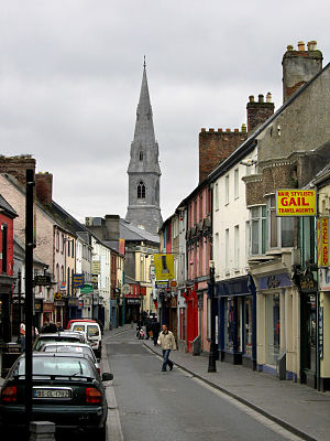
Ennis
County town of County Clare, Ireland
Distance: Approx. 487 meters
Latitude and longitude: 52.8463,-8.9807
Ennis (Irish: Inis [ˈɪnʲɪʃ], meaning 'island' or 'river meadow') is the county town of County Clare, in the mid-west of Ireland. The town lies on the River Fergus, north of where the river widens and enters the Shannon Estuary. Ennis is the largest town in County Clare, with a population of 27,923, making it the 6th largest town, and 11th largest urban settlement, as of the 2022 census.

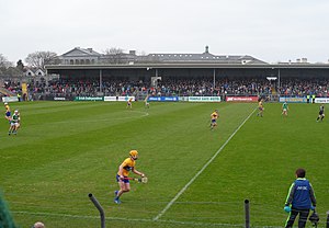
Cusack Park (Ennis)
Gaelic games stadium in County Clare, Ireland
Distance: Approx. 602 meters
Latitude and longitude: 52.84631389,-8.97866111
Cusack Park (Páirc Uí Chíosóg in Irish) is a GAA stadium in Ennis, County Clare, Ireland. It is the primary home of the Clare Hurling, Gaelic Football, Camogie and Peil na mBan teams at all grades. Named after the founder of the GAA, Michael Cusack, the ground had an original capacity of about 28,000 (mostly terraced), but following a 2011 safety review, the certified capacity was reduced to 14,864.
Clare FM
Radio station
Distance: Approx. 635 meters
Latitude and longitude: 52.84553889,-8.97751667
Clare FM is an Irish radio station which broadcasts to County Clare and the surrounding areas. The station has won many Irish radio awards. Clare FM broadcasts on frequencies 95 - 96FM including 95.2, 95.5, 95.9, 96.4 & 96.6.
Ennis National School
Distance: Approx. 257 meters
Latitude and longitude: 52.84138889,-8.9875
Ennis National School is a primary school in Ennis, County Clare, Ireland opened in 1897. It was a boys' school for 95 years before becoming co-educational in 1992. As of the 2018–2019 school year, it had 38 individuals in its teaching staff.
Rice College
School in Ennis, County Clare, Republic of Ireland
Distance: Approx. 682 meters
Latitude and longitude: 52.84805556,-8.97944444
Rice College (Coláiste an Rísigh in Irish) is a secondary school in Ennis, County Clare, Ireland founded in 1826. It is also a C.B.S with a house on the property where "Brothers" still reside. No Brothers teach in the secondary school but it was previously run by the religious order.

Roman Catholic Diocese of Killaloe
Catholic diocese in Ireland
Distance: Approx. 620 meters
Latitude and longitude: 52.84881389,-8.98964167
The Diocese of Killaloe ( kil-ə-LOO; Irish: Deoise Chill Dalua) is a Latin diocese of the Catholic Church in mid-western Ireland, one of six suffragan dioceses in the ecclesiastical province of Cashel and Emly. The cathedral church of the diocese is the Cathedral of Ss Peter and Paul in Ennis, County Clare. The incumbent bishop of the diocese is Fintan Monahan.
Cloughleigh
Populated place in Munster, Ireland
Distance: Approx. 410 meters
Latitude and longitude: 52.84361111,-8.9925
Cloughleigh, officially Cloghleagh (Irish: an Chloch Liath), is a townland and residential area of Ennis, County Clare, Ireland. It is mostly made up of bungalows, semi-detached houses and terraced houses. There is a community centre, playing fields and a playground in the estate, as well as a national school, which is financed directly by the State, but administered jointly by the State, a patron body, and local representatives.

St Columba's Church, Ennis
Distance: Approx. 210 meters
Latitude and longitude: 52.84546944,-8.98601944
St Columba's Church is a congregation of the Church of Ireland, part of the Anglican Communion, in Ennis, County Clare, western Ireland. St. Columba's was built between 1868 and 1871 as the new building for Drumcliffe Parish to the design by architect Francis Bindon.
Glór Theatre
Distance: Approx. 641 meters
Latitude and longitude: 52.8445,-8.97698056
glór, formerly glór Irish Music Centre, is a concert and events venue in Ireland, located in the town of Ennis County Clare. Its capacity allows for 485 people for seated performances. glór also has a studio space for smaller events and artist use, an art gallery, café and bar.

Ennis Cathedral
Church in County Clare, Ireland
Distance: Approx. 302 meters
Latitude and longitude: 52.8416355,-8.9832973
The Cathedral of Saints Peter and Paul (also known as Ennis Cathedral), is the cathedral church of the Roman Catholic Diocese of Killaloe. It is located in Ennis, County Clare, Ireland.

Clare Museum
County museum in County Clare, Ireland
Distance: Approx. 327 meters
Latitude and longitude: 52.84416,-8.98163
Clare Museum (Irish: Músaem an Chláir) is a museum which documents the history of County Clare. The museum is housed in the former Sisters of Mercy Convent in the centre of Ennis.

Ennis Town Hall
Municipal building in Ennis, County Clare, Ireland
Distance: Approx. 253 meters
Latitude and longitude: 52.8425,-8.9831
Ennis Town Hall (Irish: Halla Baile Inse) is a municipal building in O'Connell Street, Ennis, County Clare, Ireland. The building accommodated the offices of Clonmel Urban District Council until 1965 but is now used as the banqueting suite of a local hotel.
Weather in this IP's area
scattered clouds
3 Celsius
3 Celsius
3 Celsius
3 Celsius
1006 hPa
100 %
1006 hPa
998 hPa
10000 meters
0.51 m/s
180 degree
40 %