185.167.165.222 - IP Lookup: Free IP Address Lookup, Postal Code Lookup, IP Location Lookup, IP ASN, Public IP
Country:
 USA
USARegion:
City:
Location:
Time Zone:
Postal Code:
ISP:
ASN:
language:
User-Agent:
Proxy IP:
Blacklist:
IP information under different IP Channel
ip-api
Country
Region
City
ASN
Time Zone
ISP
Blacklist
Proxy
Latitude
Longitude
Postal
Route
db-ip
Country
Region
City
ASN
Time Zone
ISP
Blacklist
Proxy
Latitude
Longitude
Postal
Route
IPinfo
Country
Region
City
ASN
Time Zone
ISP
Blacklist
Proxy
Latitude
Longitude
Postal
Route
IP2Location
185.167.165.222Country
usRegion
new york
City
new york city
Time Zone
America/New_York
ISP
Language
User-Agent
Latitude
Longitude
Postal
ipdata
Country
Region
City
ASN
Time Zone
ISP
Blacklist
Proxy
Latitude
Longitude
Postal
Route
Popular places and events near this IP address
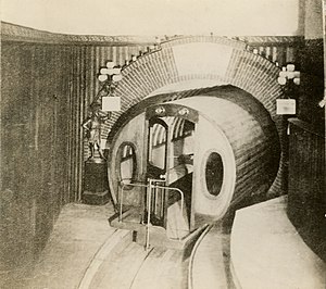
Beach Pneumatic Transit
Former demonstration subway line in New York City
Distance: Approx. 105 meters
Latitude and longitude: 40.71332,-74.00701
The Beach Pneumatic Transit was the first attempt to build an underground public transit system in New York City. It was developed by Alfred Ely Beach in 1869 as a demonstration subway line running on pneumatic power. The line had one stop in the basement of the Rogers Peet Building, near the old City Hall station, and a one-car shuttle running between the building and a dead end approximately 300 feet (91 m) away.

Tweed Courthouse
Government building in Manhattan, New York
Distance: Approx. 106 meters
Latitude and longitude: 40.71333333,-74.00555556
The Tweed Courthouse (also known as the Old New York County Courthouse) is a historic courthouse building at 52 Chambers Street in the Civic Center of Manhattan in New York City. It was built in the Italianate style with Romanesque Revival interiors. William M. "Boss" Tweed – the corrupt leader of Tammany Hall, a political machine that controlled the New York state and city governments when the courthouse was built – oversaw the building's erection.

280 Broadway
Historic building in Manhattan, New York
Distance: Approx. 40 meters
Latitude and longitude: 40.71416667,-74.00583333
280 Broadway – also known as the A.T. Stewart Dry Goods Store, the Marble Palace, the Stewart Building, and the Sun Building – is a seven-story office building on Broadway, between Chambers and Reade streets, in the Civic Center neighborhood of Lower Manhattan in New York City. Built from 1845 to 1846 for Alexander Turney Stewart, the building was New York City's first Italianate commercial building and the first department store in the United States. The building also housed the original Sun newspaper from 1919 to 1950 and has served as the central offices for the New York City Department of Buildings since 2002.

Tower 270
Building in Manhattan, New York
Distance: Approx. 44 meters
Latitude and longitude: 40.714281,-74.006765
Tower 270 (also known as 270 Broadway, Arthur Levitt State Office Building, 80 Chambers Street, and 86 Chambers Street) is a 28-story mixed use building in the Civic Center and Tribeca neighborhoods of Manhattan, New York City. Completed in 1930 to designs by E.H. Faile & Company, it has 350,785 square feet (32,589.0 m2) of floor space, on a plot with 50 feet (15 m) facing Broadway to the east and 242 feet (74 m) on Chambers Street to the north. Tower 270 is just west of New York City Hall, near several other structures, including the Broadway–Chambers Building, 280 Broadway, and the Tweed Courthouse.

49 Chambers
Residential building in Manhattan, New York
Distance: Approx. 89 meters
Latitude and longitude: 40.71388889,-74.00527778
49 Chambers, formerly known as the Emigrant Industrial Savings Bank Building and 51 Chambers Street, is a residential building at 49–51 Chambers Street in the Civic Center neighborhood of Manhattan in New York City. It was built between 1909 and 1912 and was designed by Raymond F. Almirall in the Beaux-Arts style. The building occupies a slightly irregular lot bounded by Chambers Street to the south, Elk Street to the east, and Reade Street to the north.
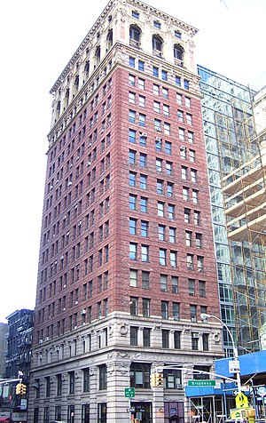
Broadway–Chambers Building
Office skyscraper in Manhattan, New York
Distance: Approx. 39 meters
Latitude and longitude: 40.71444444,-74.00638889
The Broadway–Chambers Building is an 18-story office building at 277 Broadway, on the northwest corner with Chambers Street, in the Civic Center and Tribeca neighborhoods of Manhattan in New York City. Completed by 1900 to designs by architect Cass Gilbert, the Broadway–Chambers Building was the first of several that Gilbert designed in the city. The Broadway–Chambers Building is designed in the Beaux-Arts style.

Lang School
School in New York, New York, United States
Distance: Approx. 91 meters
Latitude and longitude: 40.7149,-74.0061
The Lang School is a private, nonprofit, K-12 school marketing itself as serving the needs of twice exceptional (2e) students located in New York City's Financial District. It was the first K-12 school to specialize in educating twice-exceptional (2e) students, though it later came to include (and currently does accept) a wider range of gifted students.

287 Broadway
Historic building in Manhattan, New York
Distance: Approx. 67 meters
Latitude and longitude: 40.7147,-74.0062
287 Broadway is a residential building at the southwest corner of Broadway and Reade Street in the Civic Center and Tribeca neighborhoods of Lower Manhattan in New York City. The six-story, cast iron building was designed by John B. Snook in the French Second Empire and Italianate styles and was completed in 1872. Through the 19th and 20th centuries, it served as an office building before becoming a residential structure.

291 Broadway
Commercial skyscraper in Manhattan, New York
Distance: Approx. 94 meters
Latitude and longitude: 40.714928,-74.006113
291 Broadway, also known as the East River Savings Bank Building, is a 19-story high-rise building located at 291 Broadway and Reade Street in the TriBeCa neighborhood of Lower Manhattan, New York City. Designed by the architecture firm Clinton and Russell, the building originally housed the former East River Savings Bank. It served as the YMCA national headquarters from 1949 to 1980, and also housed the YMCA Historical Library during this time.

Bridewell (New York City jail)
Municipal prison in New York City
Distance: Approx. 34 meters
Latitude and longitude: 40.7138,-74.0062
The Bridewell was a municipal prison built in 1768 on the site now occupied by City Hall Park in the Civic Center neighborhood of Manhattan, New York City.

Washington Hall (New York City)
Distance: Approx. 55 meters
Latitude and longitude: 40.71444444,-74.00583333
Washington Hall (1809-1844) was a red brick building designed by John McComb Jr. located at the southeast corner of Broadway and Reade Street. It was built from 1809 to 1812 on the site of the African Burial Ground in what is now the Civic Center of Lower Manhattan in New York City.

Hall des Lumieres
Museum in Manhattan, New York
Distance: Approx. 95 meters
Latitude and longitude: 40.7139,-74.0052
Hall des Lumieres or Hall des Lumières is a digital art and event space located in the former Emigrant Savings Bank Building at 49 Chambers Street in the Civic Center neighborhood of Lower Manhattan in New York City. Rather than a series of traveling digital art shows, each exhibit in the space was created to fit the building's architecture. It opened in September 2022 with a show on Gustav Klimt, whose works date to the same era as the building in which it is housed.
Weather in this IP's area
scattered clouds
4 Celsius
-1 Celsius
3 Celsius
5 Celsius
1017 hPa
47 %
1017 hPa
1015 hPa
10000 meters
9.77 m/s
14.4 m/s
300 degree
40 %