Country:
Region:
City:
Latitude and Longitude:
Time Zone:
Postal Code:
IP information under different IP Channel
ip-api
Country
Region
City
ASN
Time Zone
ISP
Blacklist
Proxy
Latitude
Longitude
Postal
Route
Luminati
Country
ASN
Time Zone
Europe/Berlin
ISP
Deutsche Telekom AG
Latitude
Longitude
Postal
IPinfo
Country
Region
City
ASN
Time Zone
ISP
Blacklist
Proxy
Latitude
Longitude
Postal
Route
db-ip
Country
Region
City
ASN
Time Zone
ISP
Blacklist
Proxy
Latitude
Longitude
Postal
Route
ipdata
Country
Region
City
ASN
Time Zone
ISP
Blacklist
Proxy
Latitude
Longitude
Postal
Route
Popular places and events near this IP address

Wallraf–Richartz Museum
Museum in Cologne, Germany
Distance: Approx. 117 meters
Latitude and longitude: 50.9375,6.95861111
The Wallraf–Richartz Museum (full name in German: Wallraf-Richartz-Museum & Fondation Corboud) is an art museum in Cologne, Germany, with a collection of fine art from the medieval period to the early twentieth century. It is one of the three major museums in Cologne.

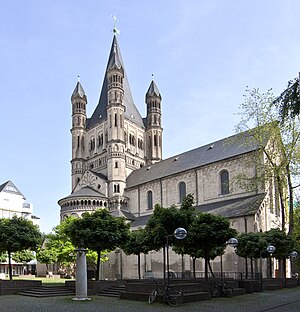
Great St. Martin Church, Cologne
Church in Cologne, Germany
Distance: Approx. 162 meters
Latitude and longitude: 50.9386,6.9618
The Great Saint Martin Church (German: Groß Sankt Martin, mostly shortened to Groß St. Martin, pronounced [ˈɡʁoːs ˌzaŋt ˈmaʁtɪn] or [- maʁˈtiːn] , Colognian: [ˈjʁus² ˌtsɪnt ˈmɛ²təs] ) is a Romanesque Catholic church in Cologne, Germany. Its foundations (c.960 AD) rest on remnants of a Roman chapel, built on what was then an island in the Rhine.

Colonia Claudia Ara Agrippinensium
Roman colony from which the German city of Cologne developed
Distance: Approx. 242 meters
Latitude and longitude: 50.93805556,6.95694444
Colonia Claudia Ara Agrippinensium was the Roman colony in the Rhineland from which the city of Cologne, now in Germany, developed. It was usually called Colonia (colony) and was the capital of the Roman province of Germania Inferior and the headquarters of the military in the region. With administrative reforms under Diocletian it became the capital of Germania Secunda.

Cologne Lowland
Distance: Approx. 246 meters
Latitude and longitude: 50.9381,6.9569
The Cologne Lowland, also called the Cologne Bay or, less commonly, the Cologne Bight (German: Kölner Bucht), is a densely populated area of Germany lying between the cities of Bonn, Aachen, and Düsseldorf/Neuss. It is situated in the southwest of the state of North Rhine-Westphalia and forms the natural southern conclusion of the Lower Rhenish lowlands and the transition to the Rhenish Massif (Rheinische Schiefergebirge or "Rhenish Slate Mountains"). The Cologne Bight is surrounded by the High Fens and the Eifel to the west of the Rhine and by the uplands of Bergisches Land to the east of the Rhine.

Fragrance Museum
Distance: Approx. 169 meters
Latitude and longitude: 50.938,6.958
The Farina Fragrance Museum is situated across from Cologne City Hall, and near the famous Wallraf-Richartz-Museum in the Obenmarspforten in Innenstadt, Cologne. Founded in 1709, John Maria Farina opposite the Jülichs Place is the eldest fragrance factory still standing and houses the registered office since 1723. Over several floors, the museum provides a very detailed insight into the production methods of perfume throughout the various stages.

Innenstadt, Cologne
Borough of Cologne in North Rhine-Westphalia, Germany
Distance: Approx. 93 meters
Latitude and longitude: 50.93666667,6.96027778
Innenstadt (German: Köln-Innenstadt) is the central borough (Stadtbezirk) of the City of Cologne in Germany. The borough was established with the last communal land reform in 1975, and comprises Cologne's historic old town (Altstadt), the Gründerzeit era new town (Neustadt) plus the right-Rhenish quarter of Deutz. The Innenstadt has about 127,000 inhabitants (as of December 2020) and covers an area of 16.37 square kilometres.

Lintgasse
Distance: Approx. 99 meters
Latitude and longitude: 50.93805556,6.96138889
Lintgasse is an alley (German: Gasse) in the Old town of Cologne, Germany between the two squares of Alter Markt and Fischmarkt. It is a pedestrian zone and only some 130 metres long, nevertheless famous for its medieval history. The Lintgasse was first mentioned in the 12th century as »in Lintgazzin«, which may have derived from basketmakers described, weaving fish baskets out of Linden tree barks.
Cologne City Hall
Historical building in Cologne, Germany
Distance: Approx. 87 meters
Latitude and longitude: 50.93798333,6.95930556
The City Hall (German: Kölner Rathaus) is a historical building in Cologne, western Germany. It is located off Hohe Straße in the district of Innenstadt, and set between the two squares of Rathausplatz and Alter Markt. It houses part of the city government, including the city council and offices of the Lord Mayor.

Hänneschen-Theater
Puppet theater in Cologne, germany
Distance: Approx. 115 meters
Latitude and longitude: 50.93694444,6.96166667
Hänneschen-Theater (German: [ˈhɛnəsçn̩ teˌʔaːtɐ], Colognian: [ˈhɛn²əsjə tiˈja²tɐ]) is a traditional puppetry-theatre in Cologne, Germany. It was established in the year 1802. The stage is situated in a building on Eisenmarkt in downtown Cologne.
Senftöpfchen
Theatre in Cologne
Distance: Approx. 250 meters
Latitude and longitude: 50.93972222,6.96083333
Senftöpfchen is a theatre in Cologne, North Rhine-Westphalia, Germany.
Rathaus station (Cologne)
Railway station in Cologne, Germany
Distance: Approx. 130 meters
Latitude and longitude: 50.93861111,6.95972222
Rathaus station is an underground station in Cologne, Germany. It is located below the Alter Markt and is named after the Cologne City Hall (German: Rathaus).

St. Maria in Jerusalem
Distance: Approx. 130 meters
Latitude and longitude: 50.93833,6.95897
St. Maria in Jerusalem was a chapel for the city council of Cologne in Germany. It was built between 1424 and 1426 when the Michaelskapelle over the market gate began to prove too small.
Weather in this IP's area
few clouds
7 Celsius
4 Celsius
5 Celsius
8 Celsius
1013 hPa
83 %
1013 hPa
1006 hPa
10000 meters
3.6 m/s
240 degree
20 %
07:52:06
16:42:33


