Country:
 Germany
Region:
City:
Latitude and Longitude:
Time Zone:
Postal Code:
IP information under different IP Channel
ip-api
Country
Region
City
ASN
Time Zone
ISP
Blacklist
Proxy
Latitude
Longitude
Postal
Route
IPinfo
Country
Region
City
ASN
Time Zone
ISP
Blacklist
Proxy
Latitude
Longitude
Postal
Route
MaxMind
Country
Region
City
ASN
Time Zone
ISP
Blacklist
Proxy
Latitude
Longitude
Postal
Route
Luminati
Country
DEASN
Time Zone
Europe/Berlin
ISP
DATAGROUP Operations GmbH
Latitude
Longitude
Postal
db-ip
Country
Region
City
ASN
Time Zone
ISP
Blacklist
Proxy
Latitude
Longitude
Postal
Route
ipdata
Country
Region
City
ASN
Time Zone
ISP
Blacklist
Proxy
Latitude
Longitude
Postal
Route
Popular places and events near this IP address

Bornheim (Frankfurt am Main)
Quarter of Frankfurt am Main in Hesse, Germany
Distance: Approx. 2021 meters
Latitude and longitude: 50.12861111,8.71166667
Bornheim is a quarter of Frankfurt am Main, Germany. It is part of the Ortsbezirk Bornheim/Ostend. In the past, Bornheim was called Das lustige Dorf ("The merry village"), because it was the red-light district of Frankfurt up to some 120 years ago.

Riederwald
Quarter of Frankfurt am Main in Germany
Distance: Approx. 1075 meters
Latitude and longitude: 50.13,8.73361111
Riederwald is a quarter of Frankfurt am Main, Germany. It is part of the Ortsbezirk Ost. Riederwald is one of the smallest districts in Frankfurt.

Deutscher Wetterdienst
German weather service
Distance: Approx. 2086 meters
Latitude and longitude: 50.103155,8.747735
The Deutscher Wetterdienst (German pronunciation: [ˌdɔʏ̯ʧɐ ˈvɛtɐdiːnst]) or DWD for short, is the German Meteorological Service, based in Offenbach am Main, Germany, which monitors weather and meteorological conditions over Germany and provides weather services for the general public and for nautical, aviational, hydrometeorological or agricultural purposes. It is attached to the Federal Ministry for Digital and Transport. The DWDs principal tasks include warning against weather-related dangers and monitoring and rating climate changes affecting Germany.
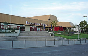
Eissporthalle Frankfurt
Indoor ice hockey venue in Germany
Distance: Approx. 1235 meters
Latitude and longitude: 50.12527778,8.72138889
Eissporthalle Frankfurt or Eissporthalle am Ratsweg is an arena in the Bornheim district of Frankfurt, Germany. It is used for ice hockey and is the home arena of Löwen Frankfurt. It is also used as an ice skating rink.

PSD Bank Arena
Multi-use stadium in Frankfurt am Main, Hesse, Germany
Distance: Approx. 1285 meters
Latitude and longitude: 50.12805556,8.72333333
The PSD Bank Arena (formerly known as Stadion am Bornheimer Hang) is a multi-use stadium in Bornheim, a district of Frankfurt am Main, Germany, and is best accessed by the Johanna-Tesch-Platz U-Bahn station (which is located on territory of the district Riederwald), or (for away fans) the Eissporthalle/Festplatz station. It is currently used mostly for football matches and is the home stadium of FSV Frankfurt and occasionally used to host 1. FFC Frankfurt (now Eintracht Frankfurt).

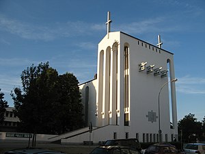
Holy Cross Church, Frankfurt-Bornheim
Church in Hesse, Germany
Distance: Approx. 1513 meters
Latitude and longitude: 50.12694444,8.71833333
The Holy Cross Church (German: Heilig-Kreuz-Kirche) is a Catholic church in the Bornheim district of Frankfurt am Main (Germany). It is similar in design to the Frauenfriedenskirche (Church of Our Lady of Peace) in Frankfurt-Bockenheim. It was built by Martin Weber from 1928 to 1929, on a rise then known as Bornheimer Hang.
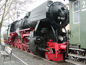
Historic Railway, Frankfurt
Heritage railway in Frankfurt am Main
Distance: Approx. 772 meters
Latitude and longitude: 50.1155,8.72975
The Historic Railway, Frankfurt (Historische Eisenbahn Frankfurt) or HEF is a German museum railway in Frankfurt am Main. The society was founded in 1978 and its aim is the preservation of historic, valuable railway materiel in working order, especially steam locomotives, as technical and cultural monuments. Since 1979 there has been a regular museum service several weekends a year on the tracks of the Frankfurt Harbour Railway (Frankfurter Hafenbahn) between the halts of Mainkur, Eiserner Steg and Frankfurt-Griesheim.

Riederwaldstadion
Football stadium in Frankfurt, Germany
Distance: Approx. 1469 meters
Latitude and longitude: 50.13305556,8.73027778
Riederwaldstadion is a stadium in Seckbach district of Frankfurt am Main in Germany. It was home pitch for Eintracht Frankfurt U23 until 2008, when Eintracht Frankfurt U23 moved. The stadium was destroyed during World War II in 1943 and was rebuilt in 1952.

Batschkapp
Rock and pop concert venue in Frankfurt am Main
Distance: Approx. 1643 meters
Latitude and longitude: 50.1353,8.7392
Batschkapp (Hessian dialect for 'flat cap') is a rock and pop concert venue in Frankfurt am Main. It is located in the warehouse district of the neighborhood of Seckbach, on Gwinnerstraße.
Holy Cross – Centre for Christian Meditation and Spirituality
Church in Hesse, Germany
Distance: Approx. 1513 meters
Latitude and longitude: 50.12694444,8.71833333
The Holy Cross – Centre for Christian Meditation and Spirituality (German: Heilig Kreuz – Zentrum für christliche Meditation und Spiritualität) is an institution of the Roman Catholic Diocese of Limburg, Germany. It is based at the Holy Cross Church in Frankfurt-Bornheim and is dedicated to services, contemplation, meditation, retreats, counseling, and other events such as concerts.

Heilig Geist, Frankfurt
Church in Frankfurt am Main, Germany
Distance: Approx. 976 meters
Latitude and longitude: 50.12916667,8.73416667
Heilig Geist (Holy Spirit) is the name of a Catholic church in the suburb Riederwald of Frankfurt am Main, Hesse, Germany. The parish church of the Riederwald congregation is part of the Roman Catholic Diocese of Limburg. On 1 January 2015 the parish became a Kirchort (church location), part of the parish St.

Offenbach-Kaiserlei station
Railway station in Offenbach am Main, Germany
Distance: Approx. 1714 meters
Latitude and longitude: 50.1053,8.7398
Offenbach-Kaiserlei station is a railway station in Offenbach am Main, Hesse, Germany.
Weather in this IP's area
clear sky
15 Celsius
14 Celsius
13 Celsius
16 Celsius
1018 hPa
69 %
1018 hPa
1006 hPa
10000 meters
3.09 m/s
40 degree
07:31:32
18:54:59