185.163.191.131 - IP Lookup: Free IP Address Lookup, Postal Code Lookup, IP Location Lookup, IP ASN, Public IP
Country:
Region:
City:
Location:
Time Zone:
Postal Code:
IP information under different IP Channel
ip-api
Country
Region
City
ASN
Time Zone
ISP
Blacklist
Proxy
Latitude
Longitude
Postal
Route
Luminati
Country
ASN
Time Zone
Europe/Copenhagen
ISP
Adeo Datacenter ApS
Latitude
Longitude
Postal
IPinfo
Country
Region
City
ASN
Time Zone
ISP
Blacklist
Proxy
Latitude
Longitude
Postal
Route
IP2Location
185.163.191.131Country
Region
hovedstaden
City
copenhagen
Time Zone
Europe/Copenhagen
ISP
Language
User-Agent
Latitude
Longitude
Postal
db-ip
Country
Region
City
ASN
Time Zone
ISP
Blacklist
Proxy
Latitude
Longitude
Postal
Route
ipdata
Country
Region
City
ASN
Time Zone
ISP
Blacklist
Proxy
Latitude
Longitude
Postal
Route
Popular places and events near this IP address

Copenhagen
Capital and most populous city of Denmark
Distance: Approx. 179 meters
Latitude and longitude: 55.67611111,12.56833333
Copenhagen (Danish: København [kʰøpm̩ˈhɑwˀn] ) is the capital and most populous city of Denmark, with a population of 1.4 million in the urban area. The city is situated on the islands of Zealand and Amager, separated from Malmö, Sweden, by the Øresund strait. The Øresund Bridge connects the two cities by rail and road.

Pantomimeteatret
Distance: Approx. 168 meters
Latitude and longitude: 55.6745,12.5665
The Pantomime Theatre (Danish: Pantomimeteateret) is an open-air theatre located in the Tivoli Gardens in Copenhagen, Denmark. As indicated by the name, it is primarily used for pantomime theatre in the classical Italian commedia dell'arte tradition which is performed daily. Besides this original function, the theatre leads a second life as a venue for ballet and modern dance.

Circus Building, Copenhagen
Distance: Approx. 38 meters
Latitude and longitude: 55.6761,12.565
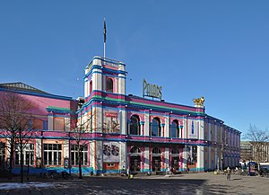
The Circus Building (Danish: Cirkusbygningen) on Axel Torv in Copenhagen, Denmark. is a circular building completed in 1886 to serve as a venue for circus performances. The last circus to use the building was in 1990.
Timeline of Copenhagen
Distance: Approx. 179 meters
Latitude and longitude: 55.676111,12.568333
The following is a timeline of the history of the city of Copenhagen, Denmark.

Palads Teatret
Distance: Approx. 146 meters
Latitude and longitude: 55.67638889,12.56333333
Palads Teatret (the Palads Cinema), also known simply as the Palads, is a cinema operated by Nordisk Film in Copenhagen, Denmark. It offers a wide selection of films in its 17 auditoriums, more than in any other Danish cinema.

Axeltorv
Square in Copenhagen
Distance: Approx. 76 meters
Latitude and longitude: 55.676,12.5643
Axeltorv is a public square in central Copenhagen, Denmark, located across the street from Tivoli Gardens' main entrance on Vesterbrogade.
Copenhagen Waterworks
Heritage industrial complex in Copenhagen
Distance: Approx. 118 meters
Latitude and longitude: 55.6768,12.5645
Copenhagen Waterworks (Danish: Københavns Vandværk) opened in 1859 in Copenhagen, Denmark. Located in Studiestræde, between Axeltorv and H. C. Andersens Boulevard, it was Denmark's first waterworks and continued operations until 1951. The complex was designated an Industrial Heritage Site in 2007 and listed in 2010.

Axelborg
Distance: Approx. 89 meters
Latitude and longitude: 55.6754,12.5644
Axelborg, located across the street from Tivoli Gardens on Vesterbrogade in Copenhagen, Denmark, is home to the Danish Agriculture and Food Council. DLG Group is also headquartered in the building. The building was built in 1920 and was originally constructed for a bank.

National Scala
Former entertainment venue
Distance: Approx. 69 meters
Latitude and longitude: 55.67527778,12.56555556
National Scala was an entertainment venue opposite Tivoli Gardens on Vesterbrogade in Copenhagen, Denmark. The building was later converted into a shopping centre and demolished in 2013.

Rådhuspladsen station
Railway station in Copenhagen Municipality, Denmark
Distance: Approx. 172 meters
Latitude and longitude: 55.6764,12.5681
Rådhuspladsen station (Danish pronunciation: [ˈʁʌðhusˌpʰlæsn̩], lit. City Hall Square) is an underground Copenhagen Metro station located on City Hall Square in central Copenhagen, Denmark. The station is on the City Circle Line (M3 and M4), between Gammel Strand and Copenhagen Central Station, and is in fare zone 1.
Industriens Hus
Distance: Approx. 159 meters
Latitude and longitude: 55.67527778,12.56777778
Industriens Hus is the home of the Confederation of Danish Industries (DI – Danish Industri). The building is located at the corner of H. C. Andersens Boulevard and Vesterbrogade, opposite the City Hall Square, in Copenhagen, Denmark. It also contains a showroom for green technologies, House of Green, as well as a series of two-storey flagship stores and restaurants on Vesterbrogade.

Ascot Hotel Copenhagen
Hotel in Copenhagen, Denmark
Distance: Approx. 111 meters
Latitude and longitude: 55.67688889,12.56525
Ascot Hotel is a 4-star highend hotel located at Studiestræde 61 in central Copenhagen, Denmark. It is located in the former Københavns Badeanstalt (Copenhagen Public Bath House), a public bath house from 1901 to 1903, as well as in some of the adjacent buildings.
Weather in this IP's area
light rain
4 Celsius
-2 Celsius
4 Celsius
5 Celsius
992 hPa
86 %
992 hPa
991 hPa
10000 meters
11.32 m/s
230 degree
75 %

