185.162.60.109 - IP Lookup: Free IP Address Lookup, Postal Code Lookup, IP Location Lookup, IP ASN, Public IP
Country:
 Hungary
Region:
City:
Location:
Time Zone:
Postal Code:
ISP:
ASN:
language:
User-Agent:
Proxy IP:
Blacklist:
IP information under different IP Channel
ip-api
Country
Region
City
ASN
Time Zone
ISP
Blacklist
Proxy
Latitude
Longitude
Postal
Route
db-ip
Country
Region
City
ASN
Time Zone
ISP
Blacklist
Proxy
Latitude
Longitude
Postal
Route
IPinfo
Country
Region
City
ASN
Time Zone
ISP
Blacklist
Proxy
Latitude
Longitude
Postal
Route
IP2Location
185.162.60.109Country
huRegion
veszprem
City
ajka
Time Zone
Europe/Budapest
ISP
Language
User-Agent
Latitude
Longitude
Postal
ipdata
Country
Region
City
ASN
Time Zone
ISP
Blacklist
Proxy
Latitude
Longitude
Postal
Route
Popular places and events near this IP address

Devecser
Town in Central Transdanubia, Hungary
Distance: Approx. 9233 meters
Latitude and longitude: 47.1061,17.4372
Devecser (Hungarian pronunciation: [ˈdɛvɛt͡ʃɛr]) is a town in Veszprém County, Hungary. In the Middle Ages there were five villages in the area of today's Devecser: Devecser, Kisdevecser, Szék, Meggyes, and Patony. These villages expanded in the 12th and 13th century.

Halimba
Place in Veszprém, Hungary
Distance: Approx. 7865 meters
Latitude and longitude: 47.03312,17.53579
Halimba (Hungarian pronunciation: [ˈhɒlimbɒ]) is a village in Veszprém county, Hungary.
Kislőd
Place in Veszprém, Hungary
Distance: Approx. 6826 meters
Latitude and longitude: 47.14553,17.62238
Kislőd is a village in Veszprém county, Hungary.
Kolontár
Place in Veszprém, Hungary
Distance: Approx. 6651 meters
Latitude and longitude: 47.084435,17.475021
Kolontár (Hungarian: [ˈkolontaːr]) is a village in Veszprém county, Hungary.

Magyarpolány
Village in Hungary
Distance: Approx. 7654 meters
Latitude and longitude: 47.17024,17.54655
Magyarpolány is a village in Veszprém county, Hungary.
Pusztamiske
Place in Veszprém, Hungary
Distance: Approx. 9594 meters
Latitude and longitude: 47.05995,17.44843
Pusztamiske is a village in Veszprém county, Hungary.
Szőc
Place in Veszprém, Hungary
Distance: Approx. 9686 meters
Latitude and longitude: 47.02069,17.51342
Szőc is a village in Veszprém county, Hungary.
Úrkút
Place in Veszprém, Hungary
Distance: Approx. 6866 meters
Latitude and longitude: 47.08191,17.64456
Úrkút is a village in Veszprém county, Hungary. South of Úrkút, there is the 238 metres tall Kabhegy TV Mast, the fourth tallest radio tower in Hungary.
Városlőd
Place in Veszprém, Hungary
Distance: Approx. 8339 meters
Latitude and longitude: 47.14372,17.65034
Városlőd (German: Waschludt) is a village in Veszprém county, Hungary. Its partner town (sister city) is Wiesthal, Germany.

Ajka alumina plant accident
2010 industrial accident in Hungary
Distance: Approx. 5006 meters
Latitude and longitude: 47.08861111,17.49583333
The Ajka alumina plant accident in October 2010 was a caustic waste reservoir chain collapse at the Ajkai Timföldgyár alumina plant in Ajka, Veszprém County, in western Hungary. On 4 October 2010, at 12:25 CEST (10:25 UTC), the northwestern corner of the dam of reservoir number 10 collapsed, releasing approximately one million cubic metres (35 million cubic feet) of liquid waste from red mud lakes. The mud was released as a 1–2 m (3–7 ft) wave, flooding several nearby localities, including the village of Kolontár and the town of Devecser.
Devecser District
Districts of Hungary in Veszprém
Distance: Approx. 9013 meters
Latitude and longitude: 47.1,17.44
Devecser District (Hungarian: Devecseri járás) is a district in the western part of Veszprém County. 'Devecser is also the name of the town where the district seat is found. The district is located in the Central Transdanubia Statistical Region.

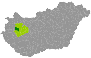
Ajka District
Districts of Hungary in Veszprém
Distance: Approx. 391 meters
Latitude and longitude: 47.10334964,17.55414193
Ajka (Hungarian: Ajkai járás) is a district in central-western part of Veszprém County. Ajka is also the name of the town where the district seat is found. The district is located in the Central Transdanubia Statistical Region.
Weather in this IP's area
overcast clouds
2 Celsius
-1 Celsius
2 Celsius
2 Celsius
1031 hPa
72 %
1031 hPa
996 hPa
10000 meters
3.19 m/s
9.28 m/s
356 degree
98 %